
The township of Adelaide River is on an emergency flooding alert as Darwin and its outer regions wake from a night of severe weather, strong winds and the risks left behind by ex-Tropical Cyclone Narelle.
Major flooding is occurring along the Upper Adelaide River.
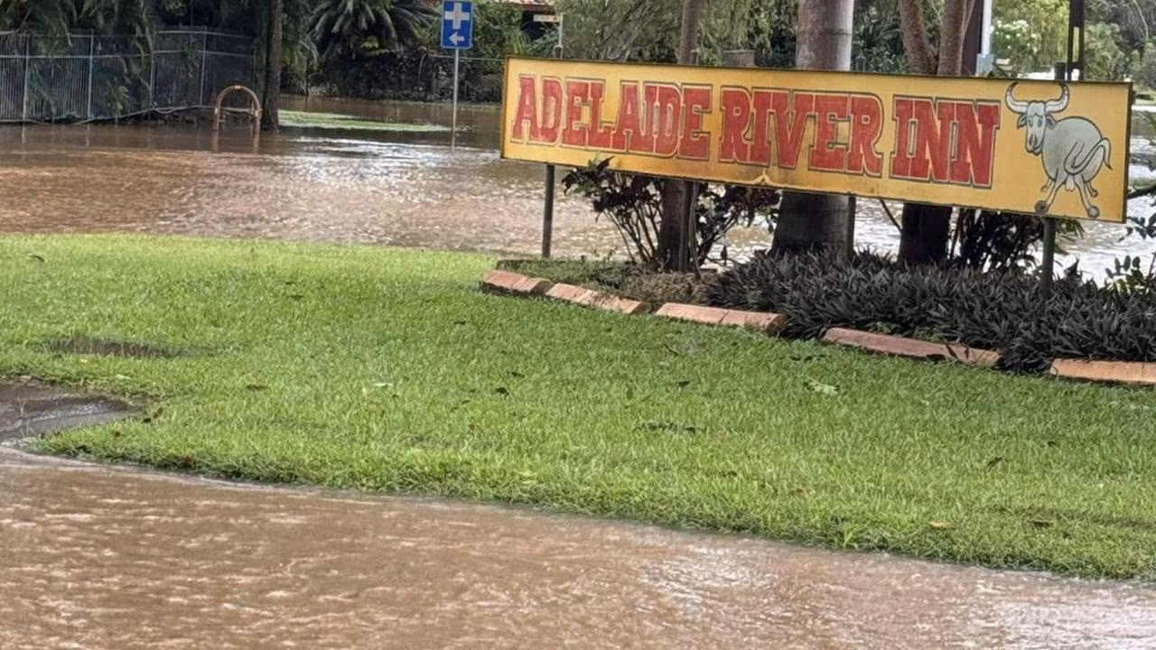
BOM data shows Adelaide River Town had 202.5mm of rainfall since 9am Saturday.
The Adelaide River at Adelaide River Town is currently at 12.62m and rising, with major flooding.
Initial reports have the floodwater up to the Adelaide River pub, with evacuations occurring.
The Adelaide River at Adelaide River Town is likely to peak near 12.7m during today midmorning, with major flooding.
Member for Daly Dheran Young urged residents to avoid unnecessary travel, as the Stuart Highway remained cut off 7km north of the town.
Traffic controllers were headed to the area on Monday morning to direct traffic.
“We’re hopeful the road will reopen later today, but please stay updated via SecureNT for the latest information,” Mr Young said on social media.
“It’s been reported that around four properties have been affected by flooding, but thankfully everyone is safe.”
It comes after authorities spent all of yesterday issuing severe weather warnings in the Top End that included the Darwin region, warning anyone impacted by weather over the past weeks to prepare for the possibility of flash flooding.
Ex-Tropical Cyclone Narelle is currently located to the east of Wadeye as a deep tropical low. The system is expected to continue moving towards the west-southwest before crossing the Daly coast later this morning.
DARWIN REGION PUT ON ALERT
March 22: At an update before midday on Sunday, before Narelle’s impact started to be felt, authorities said the Darwin River Dam was at 101 per cent capacity.
“The ground is saturated, our rivers are already full, and any additional rainfall – which could be in the hundreds of millimetres – is going to make a significant impact and it could have rapid consequences,” Chief Minister Lia Finocchiaro said.
“So people do need to stay alert. If we see flash flooding, it could include the Darwin rural area again as well.
“We know parts of Humpty-Doo, for example, and Darwin River experience flash flooding. Anyone who has seen water levels rise or been inundated and impacted, you must remain vigilant. This could impact you again.”
Many residents along the Darwin River were taken by surprise earlier this month when flash flooding inundated dozens of homes – several forced to shelter on their roofs as waters rose around them.
Bureau of Meteorology spokeswoman Jude Scott said the fact Narelle had been downgraded from a cyclone to a tropical low was no cause for complacency.
“As anyone who has spent some time in the Top End would know, it’s often the tropical lows that really bring the heavy rainfall to inland parts of the Territory,” she said.
“The distinction between a tropical low and a cyclone is largely around the wind strength wrapping around the system.”
In more positive news Ms Scott said the system was moving quickly – at about 20km/h west across the Top End.
“If we compare this current system with the system from the last few weeks that brought the extremely heavy rainfall … that was a tropical low that was quite slow moving across the Territory, and it stalled at various times, which really helped to support those heavier rainfall totals that led to the river flooding.
“This system is moving considerably faster across the Territory, so we’re expecting it to have made the entire journey from east to west within a 24 hour period.”
The severe weather warning spanned from Darwin and Palmerston, to Jabiru, Ngukurr, Larrimah, Timber Creek and Wadeye.
Heavy rainfall has caused flooding in areas across the central Top End.
Six-hourly rainfall totals between 80mm and 120mm were recorded, along with 24-hourly rainfall totals between 180mm to 230mm.
Localised damaging wind gusts up to 100 km/h were possible in the warning area into Monday morning.