
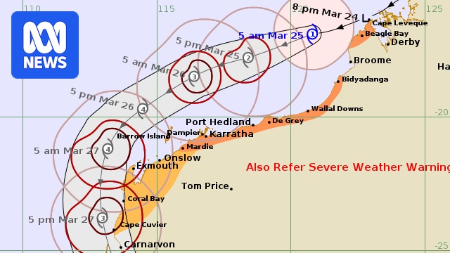
Having cut a swathe across northern Australia over the past week, Tropical Cyclone Narelle is threatening coastal communities in Western Australia, with the former tropical low strengthening to cyclone level again overnight.
Narelle is now tracking roughly parallel to the Pilbara coast, home to WA’s pivotal iron ore industry and its export operations, as it gathers pace.
It was upgraded to a cyclone as it tracked away from the Kimberley coast near Beagle Bay last night, and forecasters expect it to intensify further as it moves south.
On its present trajectory, the Bureau of Meteorology (BOM) expects it to reach severe — category three — strength as soon as tonight, when it will be offshore to the north of the Pilbara.
Damaging wind gusts of up to 100 kilometres per hour could develop between Bidyadanga and De Grey this morning, extending down to Port Hedland and Karratha as the day wears on.
Pilbara Ports, the world’s largest port authority, has begun clearing its berths from the ports of Ashburton, Cape Preston West, Dampier, and Varanus Island — disrupting the hundreds of millions of dollars in cargo that passes through its wharves daily.
Residents in Port Hedland were making preparations yesterday, with sandbags distributed at the local State Emergency Service (SES) centre.
Hedland SES Unit deputy manager Barry Harrison warned Pilbara residents not to be complacent.
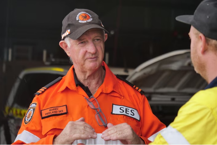
Barry Harrison says residents are preparing as Tropical Cyclone Narelle tracks off the Pilbara coast. (ABC News: Alistair Bates)
“There is a certain laziness about people in the Pilbara,” he said.
“You can never know — [cyclones] are quite dynamic events.
“Tropical Cyclone Narelle is amongst a small number that have done the three states and she’s not finished yet.”
Before, during and after a disaster, find the information you need at ABC Emergency.
The cyclone is likely to stay off the Pilbara for much of today and tomorrow, with gusts around Karratha and Exmouth possibly reaching destructive levels at 140km/h.
The system is then expected to turn south towards the coast, bringing heavy rain and high winds to much of the southern half of the state, including Perth and as far south as Albany, in the Great Southern.
The unpredictable cyclone, which has already travelled across the northern Australian coastline since forming off Queensland late last week, has made landfall three times, although it had already been downgraded to a tropical low by the time it crossed the far northern Kimberley coast on Monday.
It’s the first cyclone to traverse northern Australia from east to west in more than a decade, since Tropical Cyclone Nathan in 2015.
Unusually, Perth and the state’s South West could be significantly impacted, with heavy rain expected across much of WA’s south, including the Wheatbelt, across the weekend.
Loading