
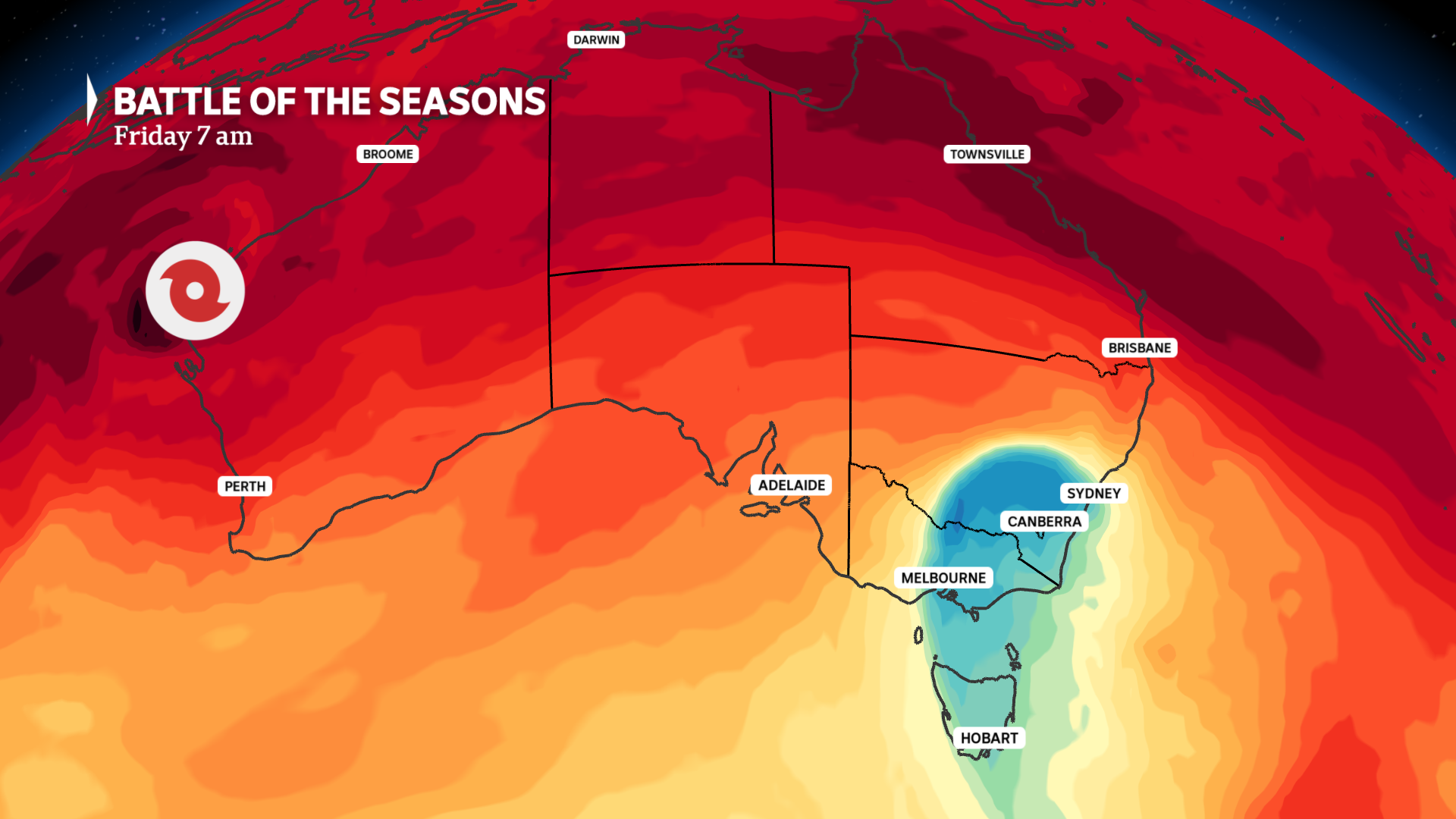
A clash of seasons is developing on Australia’s weather map this week.
As a tropical cyclone tracks towards the WA west coast, a cold polar blast with thunderstorms, gales and snow is developing over the east.
Both systems can be considered rare — the unseasonal winter storm will deliver the coldest March weather in decades, while only three previous cyclones have come within 200 kilometres of Perth since 1970.
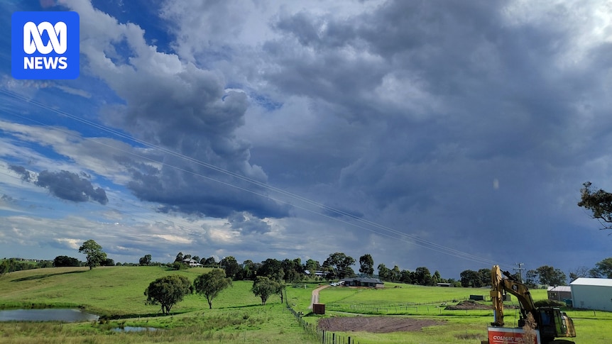
A tale of two seasons as a tropical cyclone descends down the west coast and a polar air mass crosses the south-east. (ABC News)
Gusty thunderstorms with hail and heavy rain precede front
After a warm start to the week, a cool south-westerly change reached the southern coastline on Wednesday, triggering a few pockets of storms in eastern SA and Victoria.
However, as the change tracks north through New South Wales today, thunderstorms could become far more widespread.
The outbreak of storms will rapidly develop over the state’s southern inland this morning, then intensify as it tracks across the ranges and coast this afternoon.
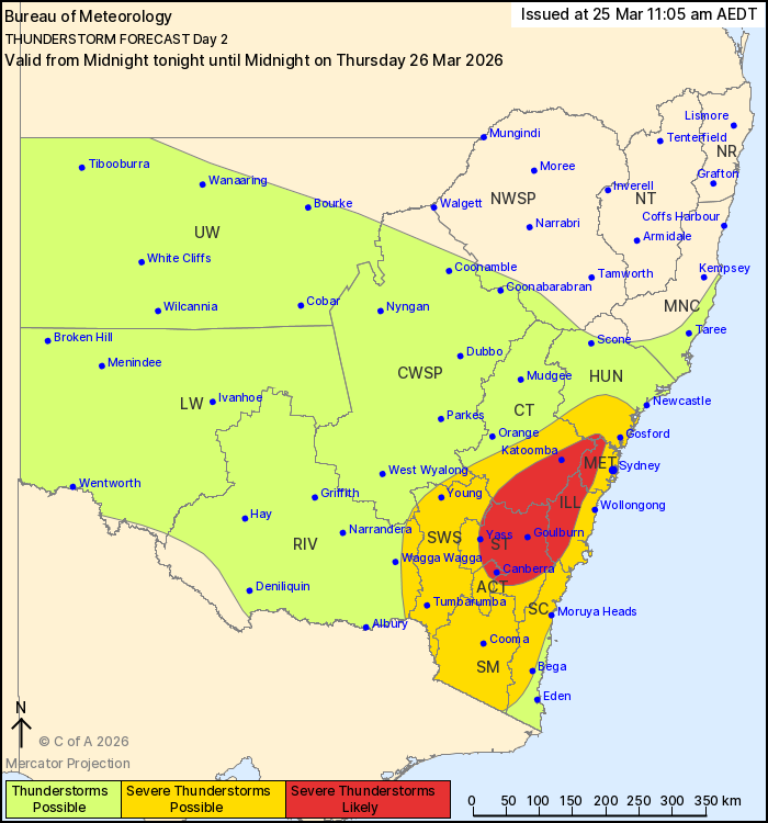
Severe thunderstorms are possible today in south-east NSW and the ACT with a threat of wind, hail and heavy rain. (Supplied: BOM)
Severe storm thresholds could be met from the Hunter and central ranges down to the Snowy Mountains, including the threat of damaging winds and large hail, along with heavy rain.
The BOM’s storm forecast also mentions the slight risk of high-end storms with giant hail, destructive winds, and intense flash flooding.
For Canberra, storms should arrive from about midday, and for Sydney from early to mid-afternoon.
Temperatures to plummet and March snow on the way
Behind the initial cool change, a wave of much colder polar air, which just three days ago was sitting near the Antarctic coastline, will surge across south-east states during the next 36 hours.
At a time of year when summer weather still typically dominates, maximums are expected to plummet as much as 13 degrees Celsius below average on Friday — the coldest March weather in years.
For some pockets of NSW and the ACT, tomorrow could bring the lowest early autumn maximums in decades, including forecasts of:
Canberra 15C — coldest March day in 18 yearsOrange 11C — coldest March day in 39 yearsGoulburn 12C — potential March recordCooma 11C — potential March recordBega 16C — coldest March day in 32 yearsThredbo 2C — coldest March day in 14 years
For Melbourne, 16C tomorrow would be the city’s coldest March day in seven years, while 20C in Sydney would be a five-year low.
The early taste of winter will also bring unseasonal snow to the mainland Alps from tonight to around lunchtime Friday, and some modelling even hints at a brief dusting reaching the highest peaks of the Central Tablelands, nearly unheard of before May.
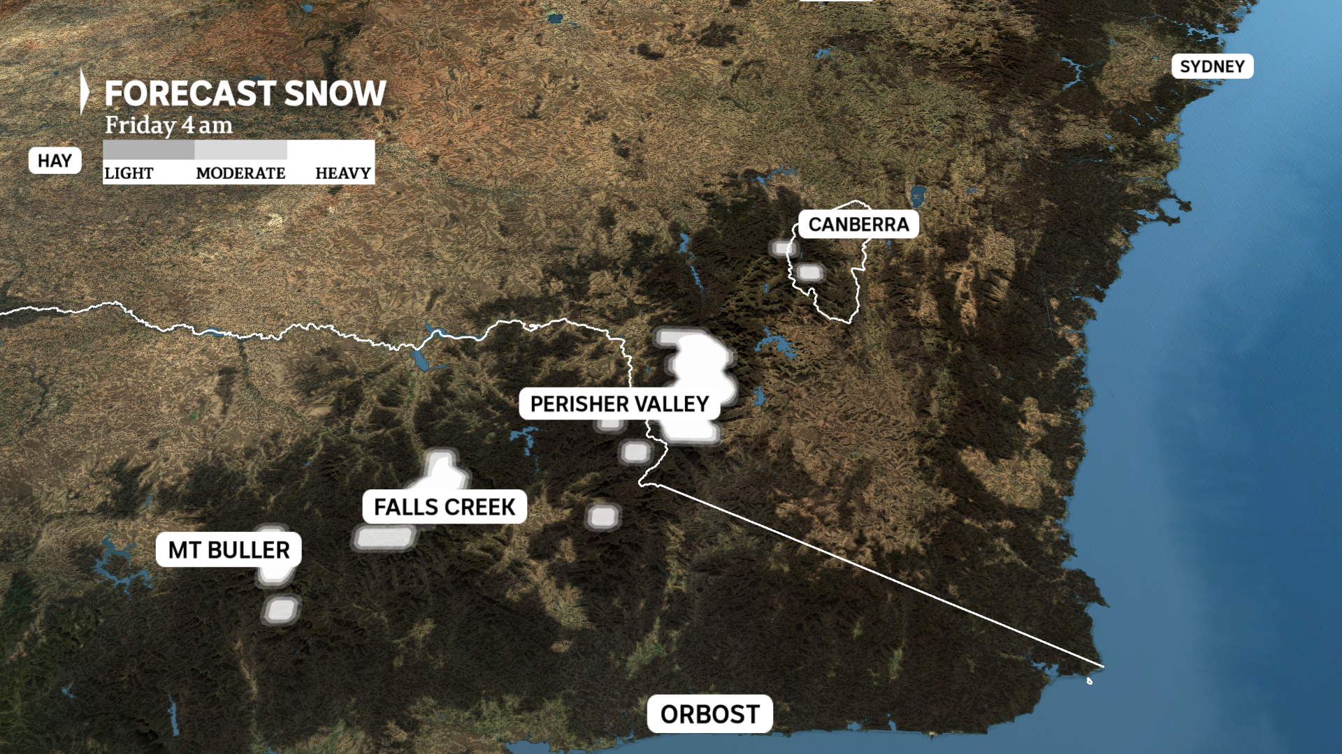
Snow is forecast on Friday morning on the mainland Alps above an elevation of about 1,400 metres. (ABC News)
For highland Tasmania, snow tonight and tomorrow should settle above an elevation of about 1,000 metres.
By Saturday, cooler and drier air will reach central Australia and southern Queensland, with overnight minimums dipping below 10C as far north as Alice Springs.
Tasman low to deliver Friday rain and gales
The arrival of a pool of cold polar air in an otherwise warm March environment will lead to the rapid formation of a low-pressure system just off the NSW coast tonight.
Thankfully, the system is unlikely to meet East Coast Low criteria; however, a period of rain and strong winds will still impact eastern Victoria and south-east NSW on Friday.
Modelling indicates up to 100 millimetres could fall over East Gippsland while gusts along the coast and ranges peak at around 90 km/h — although just offshore wind is likely to be around 30 to 40 km/h stronger, reaching speeds comparable to a category 2 tropical cyclone.
The ferocious offshore gales will whip up combined seas and swells above five metres south of the Illawarra, while hazardous surf extends north to the Hunter.
The Tasman low will retreat away from the coast this weekend, allowing winds and rain to ease.
Possible record March rain for Perth
Cyclone Narelle’s two-week journey traversing Australia’s coastline is nearly complete, and the storm is on track to become the first since Seroja in April 2021 to hit the WA west coast.
But cyclones reaching south-west Australia are extremely rare — only three have come within a 200 kilometre radius of Perth since 1970, and none have had a significant impact on the city:
Cyclone Seroja in 2021Cyclone Hazel in 1979Cyclone Beverely in 1975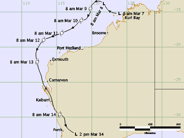
Cyclone Hazel in March 1979 came close to Perth while still at cyclone intensity but only brought 13mm of rain to the city’s official rain gauge. (Supplied)
Narelle’s presence, however, will be noticed far and wide, even well before the eye reaches southern WA.
A northerly airstream above the surface will spread a broad band of tropical moisture well ahead of the storm, leading to potentially more than 24 hours of near-continuous rainfall for Perth from Friday morning.
This could bring a two-day rain total of around 100mm — a March record for the city with data back to 1876.
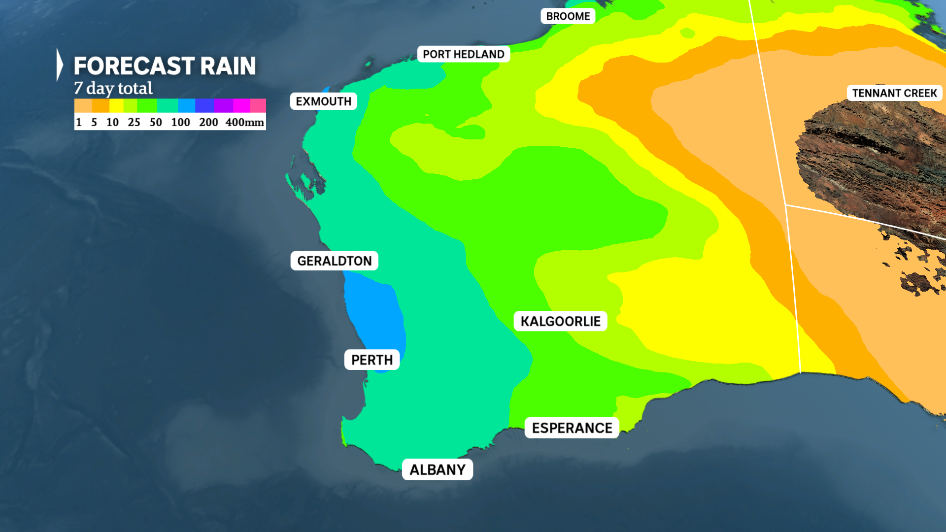
More than 50mm is likely along the west coast and adjacent inland between today and Sunday with more than 100mm possible in some areas. (ABC News)
Similar totals will extend across the western district of the state, with Albany, Mandurah, Bunbury, and Geraldton all likely to see at least 50mm by Sunday night.
Near the eye of Narelle, destructive gales will accompany the heavy rain, starting from the west Pilbara tonight and tracking down the Gascoyne coast tomorrow.
The latest modelling indicates landfall is likely near Shark Bay as a severe category 3 storm tomorrow night, but the system’s intensity should allow cyclone status to be maintained for at least 15 hours after it heads inland.
Gales are therefore likely to reach the Central West, Wheatbelt, and possibly the Great Southern and southern coast on Saturday.
However, the risk of severe wind damage for Perth is now more remote, unless the system veers west of the expected track.