

1m agoThu 26 Mar 2026 at 9:41pmExmouth Shire President describes ‘frightening situation’ after losing power

Exmouth Shire President Matthew Niikkula has described “terrifying” scenes after losing power due to cyclone Narelle.
As we reported earlier, Exmouth is expected to bear the brunt of the category four system for many more hours to come.
“It really is picking up, it’s still going to itensify a bit more than this in the next couple of hours,” Nikkula says.
“A lot of people I’ve been messaging have been hunkered down and are absolutely terrified … thinking that they’re going to lose their roof and their windows are going to come in.
“It’s just a very frightening situation, the noise is incredible, and whole buildings are shaking.”
Loading…14m agoThu 26 Mar 2026 at 9:27pmBOM warns of ‘very severe impacts’ from destructive winds, heavy rainfall
The Bureau of Metereology’s Christie Johnson has spoken to ABC’s Nate Byrne about the latest advice on Narelle.
She says the “severe” cyclone has brought sustained winds of 185 kilometres per hour around its centre and gusts of up to 260 kilometres per hour.
Narelle is currently sitting 60 kilometres northwest of Exmouth, and is expected to “recurve” as it moves southwards and then back out to the coast.
The BOM is still expecting Narelle to cross “north of Carnavon, maybe south of Coral Bay … potentially early this afternoon”.
Johnson says there could be “very severe impacts” due to destructive winds “extending quite a long way from this system,” including areas in Kalbarri and Jurien Bay.
“Obviously enough to bring down trees, powerlines, cause significant damage to properties,” she says.
“We’re looking at heavy to intense rainfall so likely flash flooding and coastal flooding with a storm surge expected along the coast.”
40m agoThu 26 Mar 2026 at 9:02pmResidents urged to take shelter now
The Department of Fire and Emergency Services (DFES) has just urged residents in the following areas to shelter indoors now:
Barrow Island and Montebellow IslandsDampier to Onslow, not including KarrathaWest of Onslow to Coral Bay
“There is a threat to lives and homes. You are in danger and need to act immediately,” the department says.
For more details on these warnings, visit the EmergencyWA website here.
51m agoThu 26 Mar 2026 at 8:50pm’Monster cyclone’ to make landfall between Cape Cuvier and Shark Bay
ABC Meteorologist Nate Byrne says Cyclone Narelle is now “curving southwards”.
“This is a monster cyclone, with a clear eye in the centre — that tells you a lot about its severity,” he says.
Bryne says the category four system is expected to cross the WA coast “somewhere between Cape Cuvier and Shark Bay” later today.
“It’s likely to carry some of that strength all the way down into the southwest of the state,” Byrne says
“Perth should see some rain out of it as it slips to the east in the early parts of tomorrow.”
1h agoThu 26 Mar 2026 at 8:35pmFierce wind and rain along Pilbara coast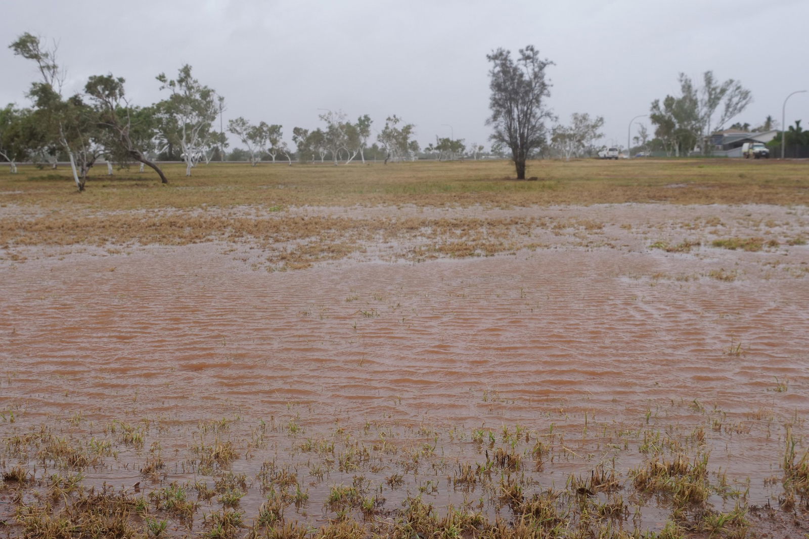 Heavy rain hit Karratha yesterday. (ABC Pilbara: Georgia Hargreaves)
Parts of WA’s Pilbara region have already felt the fierce impact of Narelle.
The tropical cyclone passed off the coast of Karratha yesterday afternoon, bringing down trees and flooding parks.
More than 40 homes in Dampier were also left without power for hours.
1h agoThu 26 Mar 2026 at 8:12pmTotal fire bans for parts of Pilbara
Just to complicate things further, there is also the possibility of bushfires in areas just outside the cyclone zone, the Department of Fire and Emergency Services (DFES) said.
Total fire bans have been issued for these areas in the Pilbara region:
AshburtonCarnarvonExmouthShark Bay
DFES Commissioner Darren Klemm said the effects of the cyclone would potentially be felt over large parts of WA, including areas inland from Kalbarri and Geraldton.
1h agoThu 26 Mar 2026 at 8:01pmNarelle chases tourists out of Shark Bay Shark Bay residents spent yesterday sandbagging properites. (Supplied: Shane Thompson)
Tourist town Shark Bay, 550km south of Exmouth, is in Tropical Cyclone Narelle’s path.
Yesterday afternoon, tour operator Greg Ridgeley said the sea off Monkey Mia was eerily calm as he prepared sandbags to protect homes and businesses.
Narelle is forecast to pass almost directly over the bay’s main town, Denham, home to about 600 people, which could feel some of the worst of the system’s impact.
“The unfortunate thing is all the tourists had to go,” Ridgeley said.
“And they won’t be back … because that cyclone will chase them all the way to Perth.”
Reporting by Jemillah Dawson
1h agoThu 26 Mar 2026 at 7:45pmExmouth to feel Narelle’s lash all morning
Bureau of Meteorology forecaster Joey Rawson told ABC radio Tropical Cyclone Narelle is just north of Exmouth and is at its peak.
He said Exmouth, on the tip of the North West Cape, is expected to feel the brunt of the system for many hours.
“It may still continue on to around midday today,” he said.
Barrow Island has already seen around 170mm of rain, Rawson said.
He added much of the rain was still offshore, which is why places like Onslow had only had about 56mm.
But more rain will reach these locations, which could get up to 200mm.
Mr Rawson said Narelle has been highly unusual in that it had managed to pass across two states and the NT.
“It’s just had the ability to follow conditions that allow this system to continue to develop once it moves over water,” he said.
Reporting by Jemillah Dawson
2h agoThu 26 Mar 2026 at 7:34pmFlights to Pilbara cancelled, LNG production grinds to a halt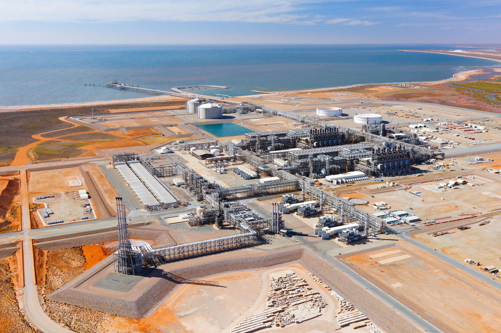 Chevron’s Wheatstone Gas Plant, west of Onslow in the Pilbara. (Supplied: Wheatstone))
As Narelle begins tracking south, flights to the Pilbara have been cancelled and around 50 schools are closed.
National parks and some major highways are also shut.
Late yesterday, oil and gas giant Chevron said it was experiencing outages at major gas facilities Gorgon and Wheatstone.
The company said LNG and domestic gas production at Wheatstone, near Onslow, had been suspended, and one of its three LNG production trains at Gorgon on Barrow Island had also ground to a halt.
“We will resume full production at both facilities once it is safe to do so,” a spokesperson said in a statement.
Reporting by Jemillah Dawson
2h agoThu 26 Mar 2026 at 6:58pm
How Narelle looks from space
The BOM’s satellite images of Narelle show the intense storm as it makes its way down the West Australian coast.
You can see a very clearly defined eye of the storm.
This photo was taken at 8:30pm AWST yesterday.
 (Supplied: Bureau of Meteorology)3h agoThu 26 Mar 2026 at 6:41pmBOM expects ‘severe impacts’ in latest warning
Severe Tropical Cyclone Narelle is currently a category four, according to the latest Bureau of Meteorology warning at 2am Perth time, and is expected to strengthen further.
“Narelle is located north of Exmouth and is turning to the south,” the BOM said.
“It is expected to pass close to the North West Cape as a category four cyclone this morning.
“Severe impacts are expected from the western Pilbara coast to the Gascoyne coast early this morning, and then extending south to Carnarvon and Denham during today.”
Narelle is packing sustained winds of 185 kilometres per hour with wind gusts up to 260 kilometres per hour.
3h agoThu 26 Mar 2026 at 6:28pmNarelle set to weaken in coming days
As of 10pm yesterday, AWST, Narelle was still a category four system.
But the storm is expected to weaken in coming days as it moves south.
This tracking map issued last night by BOM illustrate this:
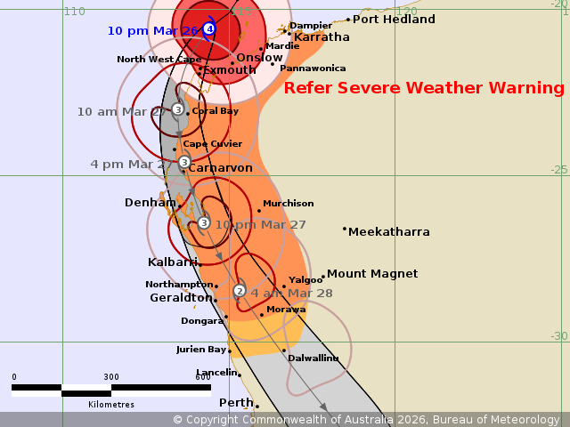 (Supplied: Bureau of Meteorology)
By 10am today, it will be west of Coral Bay as a category three and will weaken further to a category two by the time it moves onto land and situates itself east of Geraldton.
But even then, the system will remain dangerous with strong winds and heavy rainfall expected.
Cyclones generally lose steam as they move over land, and also weaken when they move further away from the equator.
3h agoThu 26 Mar 2026 at 6:28pm
Welcome to our live coverage of TC Narelle
Good morning. I hope you are all staying safe and dry this Friday morning.
Welcome to our live coverage of Severe Tropical Cyclone Narelle as it threatens WA coastal communities. We’re monitoring the latest updates from the Bureau of Meteorology and our reporters in the region.
Stand by as we bring you the latest.