
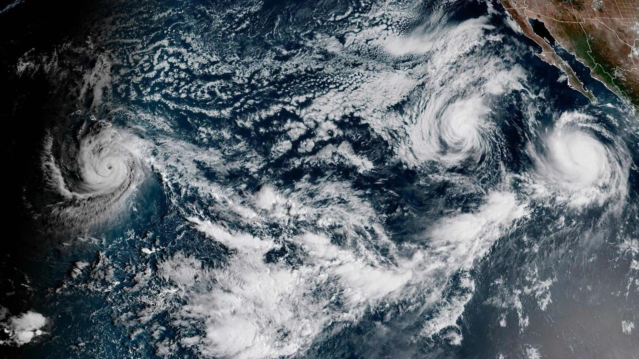
Three hurricanes are storming across the Pacific. And a wall of water is marching on California. Meanwhile, the Atlantic remains disquietingly calm.
Nature is struggling to find its balance.
Be the first to know when news breaks. Download our new app
Hurricane Polo crossed the coast of Mexico’s Baja California state overnight, bringing with it flash flooding and “life-threatening” 175km/h winds. It exploded into existence last week, strengthening from a tropical storm to a Category 5 Hurricane in less than 24 hours.
Another tropical storm, Rachel, is brewing nearby. It’s expected to reach hurricane strength in the next day or so.
Hurricane Odalys was a Category 4 just days ago. It’s now wandering the open ocean while weakening.
Hurricane Nolo pumped itself up to Category 4 (also within 24 hours) before sliding just south of the Hawaiian Islands at the weekend. That makes it the third (including Lala and Lowell) to do so this year.
“2026 thus marks the first time in recorded history in which two or more hurricanes have each passed within 50 miles [80km] of Hawaii, and joined only a handful of other years when three storms came within 100 miles [160km],” University of California researcher Dr Daniel Swain noted.
Normally, 12 tropical storms would have spawned in the Pacific by the end of September.
This year there have been 17.
It’s also the first time in recorded history that no hurricane has formed in the Atlantic.
Usually, by the end of September, there would have been about five Category 1 to 2 hurricanes and two “major” hurricanes of Category 3 and over.
“It has already been a remarkable, and arguably historic, East Pacific hurricane season,” Dr Swain said.
He said a measure of total storm activity over the Pacific, the Accumulated Cyclone Energy (ACE) score, is about 230 per cent (more than double) the average.
“All in all, this represents a fairly dramatic validation of rather bold seasonal outlooks made as far back as the spring as soon as our big El Nino event began to come into focus,” he concluded.
Weather spiral
“The passage of the hurricane in Baja California Sur has left us with rain, but no loss of life,” the state’s governor, Victor Castro, said shortly after Polo made landfall.
It has since weakened to a tropical storm and is expected to bring heavy winds and rainfall to 10 US states, including Arizona, New Mexico, Texas and Colorado.
“The most concerning effects of Polo may not actually be in Mexico at all – but instead across the interior Southwest and Southern Plains of the United States,” Dr Swain added.
“This very heavy rainfall will be a mixed blessing in the midst of a severe drought – while water is much needed here, it will probably be too much of a good thing.”
While no hurricanes have yet formed in the Atlantic, a few tropical storms have emerged from the Saharan coast.
The United States’ eastern seaboard has been hit by a strong nor’easter (noncyclical) storm in recent days. Torrential rains, damaging winds and coastal flooding have lashed the coast from Maine to North Carolina.
But no storm has even approached hurricane status yet.
“This is exactly as had been predicted,” Dr Swain stated.
“A rapidly strengthening El Nino event has dramatically weakened storm-decapitating vertical wind shear in the Pacific and warmed tropical and subtropical ocean temperatures atop the already considerable global warming trend.
“And the tropical Atlantic, by contrast, is experiencing one of its quietest seasons on record due in large part to El Nino-induced strengthening of that same storm-decapitating wind shear.”
Ocean rise
El Nino is the name given to the periodic rise in ocean temperatures in the East Pacific, off the coast of South America.
This year has been far more intense than usual.
Water temperatures are at record highs. And the phenomenon doesn’t normally peak for at least another one to two months.
This year is therefore experiencing an especially strong “swelling” in the equatorial eastern Pacific Ocean’s surface. And it’s pushing further north than ever seen before.
This average 30cm sea level rise is expected to lead to damaging coastal erosion, inundation and storm surges along Mexico and into Southern California.
“Tides are already running a foot or more above average thanks to the extreme marine heatwave,” Dr Swain explained.
“And additional sea level elevation may begin soon as the largest coastally-trapped Kelvin wave of the El Nino-generated sequence thus far arrives in October.”
A Kelvin wave is caused by a weakening or reversal of the equatorial trade winds that normally blow the warm water toward Indonesia and Australia. When a strong El Nino cuts this wind pressure, the water sloshes back into the depression it leaves behind.
The story is different for the Western Pacific.
Typically, strong El Nino years decrease the odds of cyclones forming in the Coral Sea to Australia’s east. And while waters around much of the coast are currently up to 3C above average, those to the north and northeast have cooled to about 1C below average in some areas.
Jamie Seidel is a freelance writer