
Many of Australia’s capitals are in for a wet Thursday as rainfall records tumble in the outback.
Sydney, Brisbane and Darwin have an 80 per cent chance of rain over the day, while Melbourne, Canberra, Perth and Adelaide are due for partly cloudy skies.
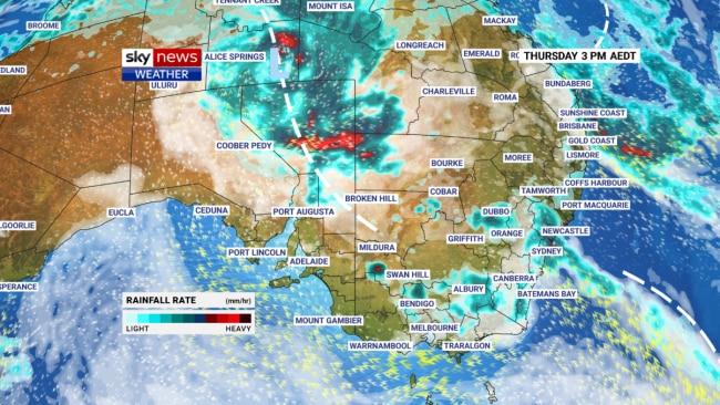
A near-stationary tropical low over the Simpson Desert has caused widespread rain, thunderstorms and flooding across four states in the nation’s interior.
Mt Isa’s monthly rain total reached 318.6mm on Wednesday, smashing the previous record of 282.5mm. Mt Isa records date back to 1926.
Alice Springs, up to Wednesday, saw 15 days of rain in February, beating previous streaks, but has not seen its highest rainfall total for a February, which is 241.6mm.
As of Wednesday evening, the town received 180.4mm of rain from the beginning of February.
Unusually, the low-pressure system has hovered over the south of the Northern Territory since the beginning of the week.
The system is not expected to change significantly in the next couple of days, with Sky News meteorologist Rob Sharpe forecasting “a lot more [rain] still to come” in the region.
A low-pressure trough associated with the system is expected to shift westward in coming days, dragging wet weather further into South Australia and western NSW at the beginning of next week.
On Thursday, the east coast of NSW, particularly Sydney and the Central Coast, is likely to see a “ribbon of rain” passing through.
The state is likely to see rain periods on top of showers as southeasterly and easterly winds converge over the central coastal areas.
Showers are tipped to increase in southeast Queensland going into Thursday night.
Brisbane is looking at a maximum temperature of 30C before the rain develops later in the day.
Sydney will see tops of 25C under the showers, with heavy falls likely in central areas surrounding Dubbo.
Melbourne is expected to see a maximum of 26C under cloudy skies, while a cloudy day looms for Hobart with temperatures reaching just 20C.
Adelaide will see a maximum of 32C under partially cloudy skies, while the north of the state receives heavy rain and thunderstorms particularly in the east.
Several weather warnings have been triggered in that area of the state.
A west coast trough is set to bring dry and sunny conditions to Western Australia’s coastline, with the mercury in Perth tipped to climb to 32C during the day.
The nation’s tropical north can expect to see widespread rain and thunderstorms from Cape York across the Gulf of Carpentaria into the Kimberley region.
The Northern Territory’s eastern and southeastern regions will also receive a heavy deluge while the capital, Darwin, in for a showery day with a top of 32C.