
Yesterday, 7:58pmWed 18 Mar 2026 at 7:58pmStay up to date with the latest emergency warnings
You can head to the ABC Emergency website for all updates, including a map of all warnings.
ABC Emergency will broadcast regular warnings on ABC Radio, which you can stream on the ABC Listen App.
Here are the radio frequencies for local stations:
Cairns and surrounds: 801 AM and 106.7 FMCairns North: 95.5 FMCoen: 105.9 FMCooktown: 105.7 FMLakeland: 106.1 FMLaura: 106.1 FMMossman and surrounds (including Daintree, Port Douglas): 639 AMWeipa: 1044 AM
ABC Far North is also available on Channel 211 through the VAST satellite service.
You can also keep across the latest warnings from the Bureau of Meteorology on its website.
5h agoThu 19 Mar 2026 at 3:38pmThat’s it from this blog, but ABC coverage continues
Ahead of the next Bureau of Meteorology update, we’re shutting down this live blog for Thursday and launching a fresh one for Friday, which you can find here.
You can join me there to keep following the latest developments, official warnings and coverage from the Bureau of Meteorology, Queensland and Northern Territory governments, and our teams out in the field.
Thanks for reading and contributing to our live coverage as we’ve brought you the latest. Stay safe!
5h agoThu 19 Mar 2026 at 3:10pm
Narelle will ‘add to the case’ for a shelter in Lockhart River

Speaking earlier, Lockhart River Aboriginal Shire Council chief executive Dave Clarke said he is concerned they can not offer an extra level of security for those who need it.
It is seven years since Cyclone Trevor hit and Mr Clarke says he believes Narelle would “add to the case” for a shelter.
“It can’t just be a standalone thing that we use every five to six years, but we could work out a multifunction model that could sustain it in my opinion.
“It is something we can investigate further and lobby the government for.”
However he says as it is isolated the community is used to managing things on its own.
“Prepare for the worst and hope for the best, the usual routine,” he says.
“Not looking forward to it, this one is a bit of a beast.”
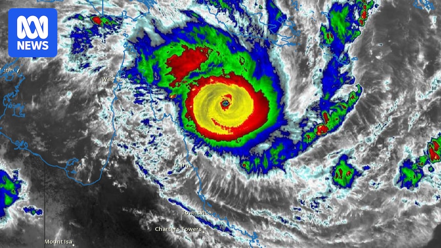
6h agoThu 19 Mar 2026 at 2:17pmLatest on Severe TC Narelle’s position
The latest warning issued for Severe Tropical Cyclone Narelle shows that the system is picking up a bit of speed as it tracks towards the Far North Queensland coast.
It will be a category five storm when it crosses the coast between Lockhart River and Cape Melville, and is currently moving west at 20 kilometres an hour.
As of 11pm AEST, the system was 205 kilometres north of Cooktown.
A seek safe shelter indoors emergency warning has been issued for the community of Wujal Wujal, with 10 other communities being urged to either prepare now or prepare to take shelter.
Gales were expected to start Thursday evening, strengthening to destructive winds through the night and very destructive at the system’s centre. Heavy to intense rain causing flash floods is forecast for Friday.
But in some good news, the system’s strength after it makes landfall is now predicted to be weaker than in previous forecasts, as its now expected to weaken into a category two before it moves into the Gulf of Carpentaria. It will regain strength there as it heads towards the Top End coast.
6h agoThu 19 Mar 2026 at 2:00pm
Latest information for territorians
Any news from the Nt Government?
– Al
Hi Al,
Our team in the Northern Territory has been monitoring the latest advice. The most recent BOM warning includes this advisory from the NT Emergency Service:
NTES advises:
People between Port MacArthur and Nhulunbuy, and inland to Ngukurr, should consider what action they will need to take if the cyclone threat increases.
– For cyclone preparedness and safety advice, visit the Secure NT website at http://www.securent.nt.gov.au
– For emergency assistance call the Northern Territory Emergency Service (NTES) on 132 500 (for assistance with storm damage, rising flood water, fallen trees on buildings or roof damage).
The NT government and emergency services will undoubtedly provide an update later on Friday, which my colleagues in Darwin and the Top End will bring to you.
In the meantime, here’s our latest story on how the NT is preparing ahead of Severe Tropical Cyclone Narelle:
7h agoThu 19 Mar 2026 at 1:46pm
Cyclone advice for pet owners
Ulysses Vet Clinics at Cairns has shared some advice to keep furry and feathered friends safe during the cyclone.
● Ensure microchip details are current and your pet is wearing a collar with an identification tag.
● Identify the safest room in your house away from windows. Ensure outdoor pets have access to high, dry ground.
● Stock a pet emergency kit that includes at least five days of food, bottled water, bowls, a lead, and essential medications.
● To keep pets calm during the cyclone, have a favourite blanket, toy, or calming spray ready to help lower anxiety during heavy rain and thunder.
● Keep a current photo of your pet on your phone and a printed copy in your emergency kit.
● Keep a digital or waterproof copy of vaccination records and your vet’s contact details handy
7h agoThu 19 Mar 2026 at 1:20pm
With you overnight
And good evening! I’m online monitoring the latest updates from the Bureau of Meteorology and ABC Emergency as Severe Tropical Cyclone Narelle tracks towards the Queensland coast. We’re expecting the next update from the Bureau of Meteorology to come through at around 2am Queensland time.
In the meantime, here’s a recap of what we know courtesy of the BOM’s most recent warning from this evening:
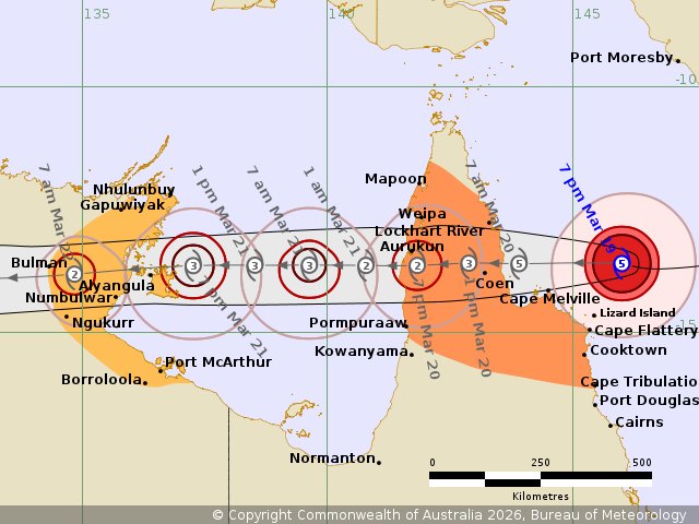
A vast swathe of Queensland’s Cape York Peninsula is under a Tropical Cyclone Warning, as TC Narelle tracks towards the coast.The warning zone stretches between Lockhart River and Cape Tribulation, and between Mapoon and Pormpuraaw, including Coen, Cooktown, Weipa, and Aurukun.Narelle is expected to make landfall sometime on Friday, bringing severe impacts to Far North Queensland.The system is a category 5 tropical cyclone, with sustained winds of up to 220 kilometres per hour near the centre, and wind gusts to 315 kilometres per hour.The system is expected to remain a cyclone as it moves into the Gulf of Carpentaria, before re-intensifying and then impacting communities in the Northern Territory’s Top End.In the NT, a cyclone watch zone extends from Nhulunbuy to Port McArthur, including Borroloola, Numbulwar, Alyangula, and Ngukurr.
As we wait for the latest information from the bureau, please make sure to keep up to date via the ABC Emergency website and through your local ABC radio station.
7h agoThu 19 Mar 2026 at 1:00pm
That’s it from me
I’m handing this blog over to my colleague Thomas Morgan who will take you through the early hours of the night and into the morning.
Stay dry and safe everyone!
8h agoThu 19 Mar 2026 at 12:50pm
Update
Is Darwin in the line of this cyclone?
– Len
Hi Len, no Darwin isn’t expected to be directly impacted by Tropical Cyclone Narelle.
The Bureau of Meteorology’s Jude Scott said yesterday that NT communities likely to be impacted included Groote Eylandt, Numbulwar and Ngukurr.
“It’s more likely to travel kind of at the base of the Top End, so pass over and move west without actually taking that hook up further north to reach Darwin,” she said.
You can also check out the bureau’s track map to see the expected path of the cyclone.
8h agoThu 19 Mar 2026 at 12:35pm
Heavy rain increasing in Cooktown
Kate Fraser owns and operates the Seaview Hotel in Cooktown and sent this video through.
“It feels like it’s starting to kick off a bit now,” she says.
Loading…
8h agoThu 19 Mar 2026 at 12:15pm
Where is the safest place in your home to go during a cyclone?
With (approximately) 9 hours until Tropical Cyclone Narelle is expected to make landfall, here’s some expert advice on where to seek shelter.
Loading…
8h agoThu 19 Mar 2026 at 12:00pm
ABC Queensland weather presenter Jacqui McLaren shares her thoughts as Cyclone Narelle approaches
Almost to the day, twenty years ago, Severe Tropical Cyclone Larry barrelled toward the Far North Queensland coast, making landfall on March 20 as a ferocious Category Four system.
Two decades later, here we are again, watching closely as another powerful cyclone, Severe Tropical Cyclone Narelle, churns toward our coastline, this time as a Category Five.
What Makes This System Unique?
Category Five coastal crossings are relatively rare.
The last system of that intensity to impact Queensland was Severe Tropical Cyclone Marcia back in 2015.
What makes Narelle stand out isn’t just its strength, it’s the structure and the jam-packed size of the system.
Unlike the earlier system this year (remember Cyclone Koji?), which was lopsided and poorly organised, Narelle is showing textbook structure: a well-organised system with strong symmetry, a clean eye, and model consistency over several days.
With the eye sharply defined on satellite imagery and track models largely in agreement, it could be labelled as, ‘the perfect storm’.
Why Is This Happening?
In short, warm sea temperatures. Narelle is currently moving over waters of around 29–30°C, providing plenty of energy or fuel for intensification.
Add to that favourable upper‑atmosphere conditions and an abundance of tropical moisture, and the environment becomes a near‑perfect breeding ground for a system of this magnitude.
This is a system to watch closely, one that again will make landfall on our Queensland coastline on March 20.
Twenty years on from Larry: a date to remember, and another system that will no doubt be talked about for years to come.
9h agoThu 19 Mar 2026 at 11:45am
Port Stewart residents evacuated
The tiny village of Port Stewart in Queensland is expected to face the full force of Cyclone Narelle when it crosses the coast tomorrow morning.
Residents of the town were evacuated to Coen last night.
Among them was Mary Withers, who has lived in Port Stewart for 30 years.
She told ABC Far North Queensland’s Adam Stephen she wanted out due to the potential for a storm surge.
Ms Withers said she only had time to grab her most personal possessions, including her husband’s ashes.
“I kind of did get a little emotional last night but you’ve got to be realistic about these things,” she said.”
“We’ll probably have nothing left, but that’s just what you’ve got to think of – think of the worst and hope for the best.”
9h agoThu 19 Mar 2026 at 11:30am
Update
9h agoThu 19 Mar 2026 at 11:15am
What’s driving Cyclone Narelle’s intensity?
That’s the question the ABC’s Fran Kelly put to climate scientist Dr Andrew Watkins.
He says hot ocean temperatures are the “fuel” which drives cyclones, and while record Coral Sea temperatures are a factor driving its intensity, it’s not the only cause.
“When you start getting record hot temperatures in the oceans … that the cyclone’s passing over it, you’re giving it every chance to be stronger than it really should be,” he says.
Right now the Coral Sea is about a degree warmer than “normal”, he says, averaging about 29.5 degrees celsius.
Dr Watkins says while the number of tropical cyclones have decreased in recent years, the ones we’re getting are actually more intense (on average).
9h agoThu 19 Mar 2026 at 11:00am
A ‘busy afternoon’ in Cooktown
ABC reporter Chris Testa has been on the ground in Cooktown today.
He filed this report earlier.
Loading…10h agoThu 19 Mar 2026 at 10:45amCyclone slowing as it approaches the coast
Senior bureau forecaster Baden Gilbert has been speaking to ABC 612.
He says Tropical Cyclone Narelle is moving at about 20 to 25 km/h.
Mr Gilbert says the cyclone has slowed down a bit “in the last hour or two” and forecasters are keeping an eye on the expected landfall time, which is currently around 7am.
The bureau has also released the latest tracker map which shows Tropical Cyclone Narelle is still set to make landfall at Category 5.
10h agoThu 19 Mar 2026 at 10:30am
Another Queenslander taking advantage of WW2-era infrastructure
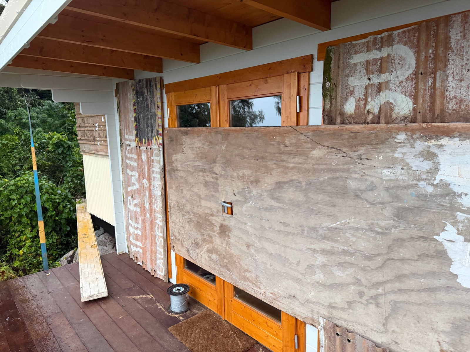
Jayson Watkin is literally preparing to bunker down for the night on his resort in Portland Roads, 150km north of Coen.
His property is built on the site of an abandoned WW2 military outpost, replete with a bunker that makes an ideal cyclone shelter.
 There’s worse places for a beer. (Supplied)
“There was never any doubt of us hunkering down [here] for the cyclone, I wouldn’t want to be anywhere else,” Mr Watkins said.
With a generator ensuring the shelter will be powered throughout the night and freshly installed cyclone shutters, Mr Watkin is all set to see out a blustery evening.
 The hard work preparing the resort is done. (Supplied)
“We’ve done the hard work and we’re reaping the benefits now, and sipping on a nice cold [beer] and enjoying the view,” he said.
 The calm before the storm. (Supplied)
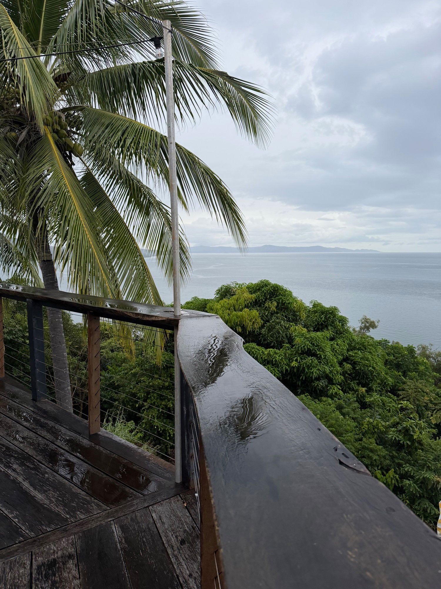
10h agoThu 19 Mar 2026 at 10:15am
ABC reporters have been out and about in north Queensland today
ABC reporter Kristy Sexton-McGrath has been on the ground in Cairns.
Loading…
10h agoThu 19 Mar 2026 at 10:00am
The ocean is getting rougher as Cyclone Narelle approaches the coast
Tess Cooper sent in these videos taken at Ellis Beach near Cairns just before 6pm.
Loading…Loading…