
11m agoThu 19 Mar 2026 at 9:07pmStay up to date with the latest emergency warnings

You can head to the ABC Emergency website for all updates, including a map of all warnings.
ABC Emergency will broadcast regular warnings on ABC Radio, which you can stream on the ABC Listen App.
Here are the radio frequencies for local stations:
Cairns and surrounds: 801 AM and 106.7 FMCairns North: 95.5 FMCoen: 105.9 FMCooktown: 105.7 FMLakeland: 106.1 FMLaura: 106.1 FMMossman and surrounds (including Daintree, Port Douglas): 639 AMWeipa: 1044 AM
ABC Far North is also available on Channel 211 through the VAST satellite service.
You can also keep across the latest warnings from the Bureau of Meteorology on its website.
2m agoThu 19 Mar 2026 at 9:16pm
WATCH: Cyclone Narelle moving towards the coast ‘very swiftly’
If you are just joining us, the Bureau of Meteorology’s Angus Hines has provided an update on how Tropical Cyclone Narelle is tracking.
The category four system is expected to cross the coast “imminently” after moving “very swiftly” towards the coast overnight.
Loading…
8m agoThu 19 Mar 2026 at 9:10pm
What wind gusts of up to 270km/h can feel like
Tropical Cyclone Narelle is producing sustained winds near the centre of the system of 195 km/h with wind gusts of up to 270km/h.
ABC Far North’s Charlie McKillop has reminded listeners of what winds that strong can do.
“That could mean that you aren’t able to stand or walk, you could be thrown off your feet instantly,” she says.
“Not to mention the additional threat of airborne debris, whether that’s branches, metal or glass, they could become lethal projectiles.”
The Bureau of Meteorology’s Felim Hannify says the system is expected to cross in the next half hour.
“When you’ve got the core of those destructive winds, they extend out for 20km,” he says.
“You’re looking for a peak hour to an hour and a half before that system moves further westward.”
16m agoThu 19 Mar 2026 at 9:02pm
WATCH: The towns being impacted by Tropical Cyclone Narelle
The ABC’s Nate Byrne is in Weipa as the category four system approaches the coast.
It is a remote part of the country. Watch below as he explains which communities will be impacted by Tropical Cyclone Narelle.
Loading…
27m agoThu 19 Mar 2026 at 8:51pm
Residents ‘nervous’ as TC Narelle approaches coast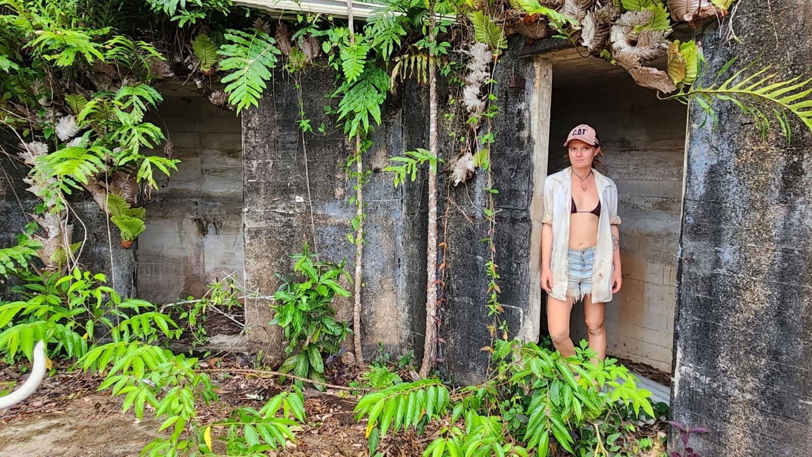 Tilly Rehn, pictured on Thursday, is in Portland Roads. (Supplied)
In the small community of Portland Roads, an hour’s drive north of Lockhart River, and 800km north of Cairns, residents say they’re ready for the cyclones crossing.
Tilly Rehn will be sheltering with her neighbours in a concrete World War II bunker.
“It’s not underground, but it’s solid and it’s been standing for decades,” she says.
She says the entire community of 10 people is well prepared.
“I’m feeling a little bit nervous, it will be scary and a massive clean-up afterwards, but we’ve got a really good little community here,” she says.
She says the entire community is off-grid, which means they already have the skills to get power and water running after the cyclone passes.
“We don’t have tradesmen, plumbers and diesel fitters, so the job list for us is long on a daily basis.”
35m agoThu 19 Mar 2026 at 8:43pm
Preparing for impact in Coen
Lucretia Huen says her husband and nine-year-old daughter are bunkering down at the Wellbeing Centre in Coen where the power has gone out.
 Lucretia Huen’s daughter and husband are holed up in the Coen Wellbeing Centre. (Supplied: Lucretia Huen)
Ms Heun is away for work and said it’s an “emotional rollercoaster” not being with her family.
“They have heard branches start to fall on the roof but no real damage yet,” she said.
Loading…
Ms Huen said the Wellbeing Centre is not cyclone-rated but is the only option to community.
“For years, the Coen community has called for a purpose-built cyclone shelter. Those calls have gone unanswered,” she said.
“This situation highlights a broader failure in preparedness and equitable infrastructure investment in remote communities.”
1h agoThu 19 Mar 2026 at 8:17pmTropical Cyclone Narelle likely to cross coast in the next hour
Angus Hines from the Bureau of Meteorology says it is expected to arrive on the east coast within the next hour.
“Then it will take about 12 to 18 hours to cross the peninsula and move into the Gulf of Carpentaria out to the western side of Cape York Peninsula,” he says.
“We are essentially looking at this weather system being around north Queensland all day today, making its arrival in the next hour or so.
“And then finally making its departure this evening, perhaps the last few hours before midnight.”
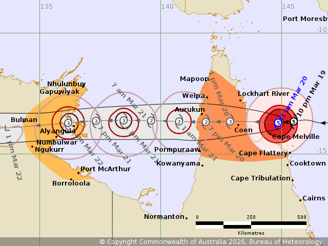
He says tomorrow it will cross the Gulf of Carpentaria and is likely to be a severe tropical cyclone again as it approaches the Northern Territory.
“We could be talking about a severe tropical cyclone reaching the top end of the Northern Territory on Saturday night, pushing into Sunday morning,” Mr Hines says.
1h agoThu 19 Mar 2026 at 8:08pm
What is expected as the cyclone crosses the coast?
“Given it is such a strong system it is expected to maintain its intensity as it moves inland,” the Bureau of Meteorology’s Christie Johnson says.
“Still looking potentially around a category four as it moves past Coen and then it will weaken as it moves to the western part of the peninsula.”
The warning zone extends from Cape York Peninsula between Lockhart River and Cape Flattery, and between Mapoon and Pormpuraaw, including Coen, Weipa, and Aurukun.
“Right near the centre is where we are expecting the very destructive winds, we’re still talking in excess of 250km/h wind gusts,” she says.
1h agoThu 19 Mar 2026 at 7:52pm
WATCH: Strong wind, heavy rain at Port DouglasLoading…
My colleague Chloe Chomicki is in Port Douglas this morning.
It is outside the warning zone for the cyclone but there is strong wind and heavy rain as the system approaches the coast.
Here’s the latest from Chloe:
“Throughout what is usually a tourist hub there is debris covering roads this morning, though there is still traffic about.
“The advice here has been to monitor the latest information — but it’s further north on the Cape York Peninsula where the advice is to take shelter now.”
1h agoThu 19 Mar 2026 at 7:36pm
WATCH: Nate Byrne is on the ground in Weipa
He has provided an update on the latest on Tropical Cyclone Narelle.
Loading…
1h agoThu 19 Mar 2026 at 7:27pm
Cyclone forecast to cross between 7am and 10am
Bureau of Meteorology forecast Baden Gilbert says TC Narelle will cross the coast east of Coen between 7am and 10am.
“But it could get there a little bit sooner depending on how things go in the next couple of hours,” he says.
Mr Gilbert says the “eye” of the cyclone appears to have “closed up” a little bit and become harder to pick when you look at satellite images.
“That’s partly because … we started to see it interact with the land near Cape Melville which has started to disrupt some of the circular flow around the core of system and there has also been a feature to the south that has started to influence it a little bit more,” he says.
“That’s why we have seen a slight weakening in the intensity but it still going to be a significant system for those near the core as it crosses.”
2h agoThu 19 Mar 2026 at 6:55pm
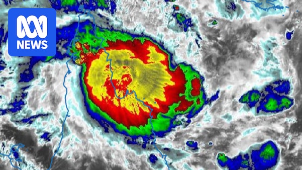
Tropical Cyclone Narelle now a category four system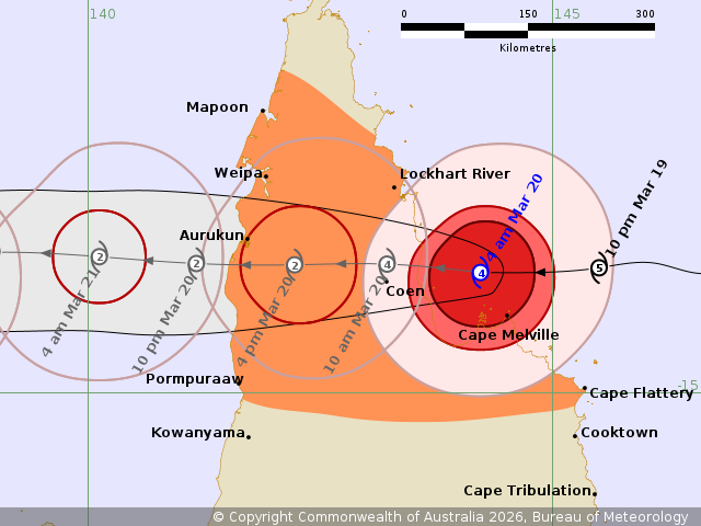 (Supplied: Bureau of Meteology)
The latest update from the Bureau of Meteorology has come through.
It shows Tropical Cyclone Narelle is a category four system with winds near the centre of 195km/h with wind gusts to 270km/h.
The BOM says very destructive winds in excess of 250km/h are possible near the centre as it crosses the Cape York Peninsula coast on Friday morning.
It’s moving westwards to cross the Far North Queensland coast between Lockhart River and Cape Melville.
The BOM says Narelle is forecast to move over Cape York Peninsula as a tropical cyclone on Friday while weakening.
Narelle will then continue moving west across the Gulf of Carpentaria and is expected to strengthen again into a severe tropical cyclone before impacting the eastern Northern Territory from late Saturday.
2h agoThu 19 Mar 2026 at 6:49pmTC Narelle will hit coast as ‘high-end’ category four
We are standing by for the Bureau of Meteorology’s next update on TC Narelle, which is expected at 5am.
But senior forecast Baden Gilbert has told ABC Radio it will show the cyclone is forecast to cross the coast as a “high-end” category four system.
“We will be having it as a high-end category four system rather than a low-end category five system,” he says.
However, he says the impact will be the same.
“There’s still going to be a very destructive core as the system crosses the coast in the area to the east of Coen and there’s still the risk of heavy to intense rainfall.
“A damaging storm surge is also possible as well as the risk of flash and riverine flooding.”
TC Narelle is expected to cross the coast in the next couple of hours.
2h agoThu 19 Mar 2026 at 6:36pm
Tracking TC Narelle’s path
With Tropical Cyclone Narelle nearing the Queensland coast, here’s a handy article put together by our colleagues at StoryLab.
Not only does it show Narelle’s future path across the Gulf and towards the Northern Territory, but also is plugged into the latest Bureau of Meteorology data, allowing us to show wind speeds in some of the communities close to the storm.
You can see the latest Narelle track map here:
3h agoThu 19 Mar 2026 at 6:16pm
Far North communities urged to take shelter now
These are the latest warnings issued by councils for a number of communities, as Severe Tropical Cyclone Narelle bears down on the Far North Coast.
A number of communities have seen their warnings upgraded in the last 15 minutes:
TAKE SHELTER NOW – Hope Vale – CYCLONE – Issued at 4:00am, Friday 20 March 2026 TAKE SHELTER NOW – Lockhart River area – CYCLONE – Issued at 4:00am, Friday 20 March 2026 TAKE SHELTER NOW – Cook Shire – CYCLONE – Issued at 4:00am, Friday 20 March 2026 TAKE SHELTER NOW – Coen and Port Stewart area – CYCLONE – Issued at 4:00am, Friday 20 March 2026 TAKE SHELTER NOW – Wujal Wujal – CYCLONE – Issued at 6:05pm, Thursday 19 March 2026 3h agoThu 19 Mar 2026 at 6:05pmNarelle expected to cross coast mid-morning: BOM
The Bureau of Meteorology’s Baden Gilbert has been providing an update to ABC Radio Far North.
He says the category five system is expected to cross the coast sometime between 7am and 10am, somewhere between Lockhart River and Cape Melville.
When it does, it will be packing sustained winds in excess of 205 kilometres an hour.
3h agoThu 19 Mar 2026 at 5:31pm
What are the impacts of a tropical cyclone?
The three major impacts of a tropical cyclone are wind, rain and storm surges.
Tropical cyclones bring gale force winds that can cause extensive damage to property and turn airborne debris into potentially lethal missiles.
Tropical cyclones can bring extensive flooding through heavy rainfall that can persist even as the cyclone moves inland and begins to weaken.
Tropical cyclones can cause the sea to rise well above the highest tide levels. This is caused by strong onshore winds and reduced atmospheric pressure.
The bureau says storm surges have the potential to be the most dangerous hazard associated with tropical cyclones.
Extreme storm surges can swamp low-lying areas and drive destructive water flow inland, sometimes for several kilometres.
4h agoThu 19 Mar 2026 at 4:45pm
WATCH: Queensland premier’s warning ahead of Narelle
Last night, the ABC’s Jessica van Vonderen spoke with Queensland Premier David Crisafulli, who warned Severe Tropical Cyclone Narelle was a big system that would impact the state’s Far North.
“It will be significant, Jessica, I can’t sugarcoat it. This is a really big system,” he said.
“And while it’s going over an area that may not be large in population, they still matter to us, they’re still Queenslanders, and they are in the firing line tonight.”
But the premier says the government has resources on the ground ready to respond as soon as it is safe to do so.
Loading…
4h agoThu 19 Mar 2026 at 4:25pm
What Cape York residents are bracing for
Now to the latest from the BOM in terms of hazards.
Residents in Severe Tropical Cyclone Narelle’s warning zone should prepare for:
Very destructive wind gusts in excess of 250 km/h are possible near the centre of Severe Tropical Cyclone Narelle as it crosses the Cape York Peninsula coast on Friday morning.Destructive wind gusts to 160 km/h are likely from south of Lockhart River to north of Cape Flattery this morning. Destructive wind gusts are likely to persist near the centre of Narelle as it moves across Cape York Peninsula during Friday.Gales with damaging wind gusts to 120 km/h are likely from Cape Flattery to north of Lockhart River. Gales with damaging wind gusts to 120 km/h are also forecast to extend across Cape York Peninsula, including areas between Mapoon and Pormpuraaw, during Friday.Heavy rainfall which may lead to flash flooding with locally intense rainfall is likely in an area of the Peninsula bounded by Lockhart River, Cape Flattery, Pormpuraaw, and Weipa during Friday.
If you want to read the full list of the system’s hazards, here’s a link to the Bureau of Meteorology’s most recent warning.
5h agoThu 19 Mar 2026 at 4:07pmBreaking: Latest BOM update says Narelle remains category five
The Bureau of Meteorology has just released its latest tropical cyclone forecast at 2am. Here’s the latest track map:
 (Supplied: Bureau of Meteorology)
And here are the key points:
Severe Tropical Cyclone Narelle will cross the Far North Queensland coast between Lockhart River and Cape Melville later this morning.It remains a category five system and is packing sustained winds of 205 kilometres an hour.It is moving westwards at 19 kilometres an hour. It is estimated to be 175 kilometres east of Coen.A warning zone in Queensland is in effect between Lockhart River and Cape Flattery, and between Mapoon and Pormpuraaw, including Coen, Weipa, and Aurukun.
A watch zone for parts of the NT is in effect for Nhulunbuy to Port McArthur, including Borroloola, Numbulwar, Alyangula, and Ngukurr.
Warnings have been cancelled for Cape Tribulation to Cape Flattery including Cooktown.
I’ll bring you a list of the hazards in Queensland in my next post.