
UPDATE: 5 p.m.
Kiko remains a Category 2 hurricane and is still predicted to weaken into a tropical storm, passing north of Hawaii early this week.
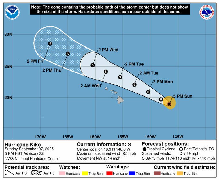
As of 5 p.m., Kiko was located about 555 miles east of Hilo and about 750 miles east of Honolulu. The hurricane was moving at near 14 mph with maximum sustained winds of 105 mph.
Kiko is expected to pass north of the main Hawaiian Islands Tuesday and Wednesday. Kiko is forecast to become a tropical storm late Monday or Monday night.
“While the risk of direct impacts on the islands appears to be decreasing, interests there should continue to monitor Kiko’s progress and the latest forecast,” according to the forecast.
Hurricane-force winds extend outward up to 30 miles from the center, while tropical-storm-force winds extend outward up to 90 miles.
Don’t miss out on what’s happening!
Stay in touch with breaking news, as it happens, conveniently in your email inbox. It’s FREE!
There are no coastal watches or warnings in effect.
11 a.m.
Hurricane Kiko continues to weaken and is expected to pass north of the Hawaiian Islands on Tuesday and Wednesday, according to the Central Pacific Hurricane Center.
As of 11 a.m. today, Kiko was located about 635 miles east of Hilo and 835 miles east-southeast of Honolulu. Kiko was packing maximum sustained winds of 110 mph and moving west-northwest at near 13 mph. Kiko is forecast to continue in this general motion with a slight increase in forward speed expected until Wednesday.
“Reports from an Air Force Reserve Hurricane Hunter aircraft indicate that maximum sustained winds have decreased to near 110 mph (175 km/h) with higher gusts. Additional weakening is forecast during the next few days, and Kiko is expected to become a tropical storm by late Monday or Monday night,” according to the forecast.
Hurricane-forece winds extend outward up to 30 miles from the center, while tropical-storm-force winds extend outward up to 80 miles.
Swells generated by Kiko are expected to hit Hawaii island and Maui today. Swells are predicted to peak along the east-facing shores of the Hawaiian Islands late Monday until midweek, possibly producing life-threatening surf and rip currents.
EARLIER COVERAGE
Kiko weakened slightly overnight but is still a major hurricane in the Central Pacific on a path that is expected to take it north of Hawaii this week.
As of 5 a.m. today, Kiko had maximum sustained winds of 115 mph and was centered 715 miles east of Hilo and 915 miles east-southeast of Honolulu, moving west-northwest at 13 mph, according to the Central Pacific Hurricane Center.
“Kiko is forecast to pass north of the Hawaiian islands on Tuesday and Wednesday,” forecasters said. “While the risk of direct impacts on the islands appears to be decreasing, interests there should continue to monitor Kiko’s progress and the latest forecast.”
Hurricane-force winds extend up to 35 miles from Kiko’s center and tropical storm-force winds extend up to 80 miles, CPHC said.
Kiko, a Category 3 storm, is now moving over cooler waters and is expected to encounter wind shear in about 24 hours, both of which should hasten its weakening, forecasters said in the 5 a.m. update.
The latest five-day forecast track has Kiko as a Category 1 hurricane on Tuesday and a tropical storm on Wednesday as it passes north of Hawaii. The islands are no longer included in the track’s so-called cone of uncertainty. By Thursday, the storm is expected to be far northwest of Hawaii.
Although there are no Kiko-related advisories covering land in the islands, offshore Hawaii waters beyond 40 nautical miles out to 240 nautical miles including the portion of the Papahanaumokuakea Marine National Monument east of French Frigate Shoals are under a hurricane warning. The National Weather Service in Honolulu said 6-to-12-feet seas are expected Tuesday and Wednesday, as well as isolated thunderstorms.
NWS forecasters said the islands, meanwhile, may see a “brief enhancement in shower activity through Monday morning.”
“Overall, the region will remain relatively dry and stable the next couple of days. Cloudier, warm and muggy island weather is forecast Tuesday and Wednesday under weakened trade flow,” they said today. “Hurricane Kiko is approaching Hawaii from the southeast. Kiko’s current forecast track remains north of the islands across the far northern offshore waters. While confidence is low concerning Kiko’s early to mid week impacts, there is a possibly of higher statewide rainfall and elevated east-facing shore surf. “
Swells generated by Kiko are expected to reach Hawaii island and Maui today. “These swells will gradually build and are forecast to peak along east-facing exposures of the Hawaiian islands late Monday through midweek, potentially producing life-threatening surf and rip currents,” forecasters said.