
![]()
Listen to this article
Estimated 5 minutes
The audio version of this article is generated by AI-based technology. Mispronunciations can occur. We are working with our partners to continually review and improve the results.
First Nations in British Columbia’s central Interior are sounding the alarm over landslide risk along the same stretch of the Chilcotin River where a massive slide blocked the waterway for several days in the summer of 2024.
The Tŝilhqot’in National Government issued a statement saying a geotechnical report commissioned by the province after that slide found an “imminent” risk of rockfall into the river that supports several important salmon populations.
A photo shared by the nation shows what it describes as “tension cracks” in the steep slope above the river, with some material apparently starting to break away.
The nation says the emergency task force it convened in 2024 has developed a stabilization plan, but it was “alarmed by recent indications” from B.C. and Ottawa that funding would not be made available before this year’s migration of salmon.
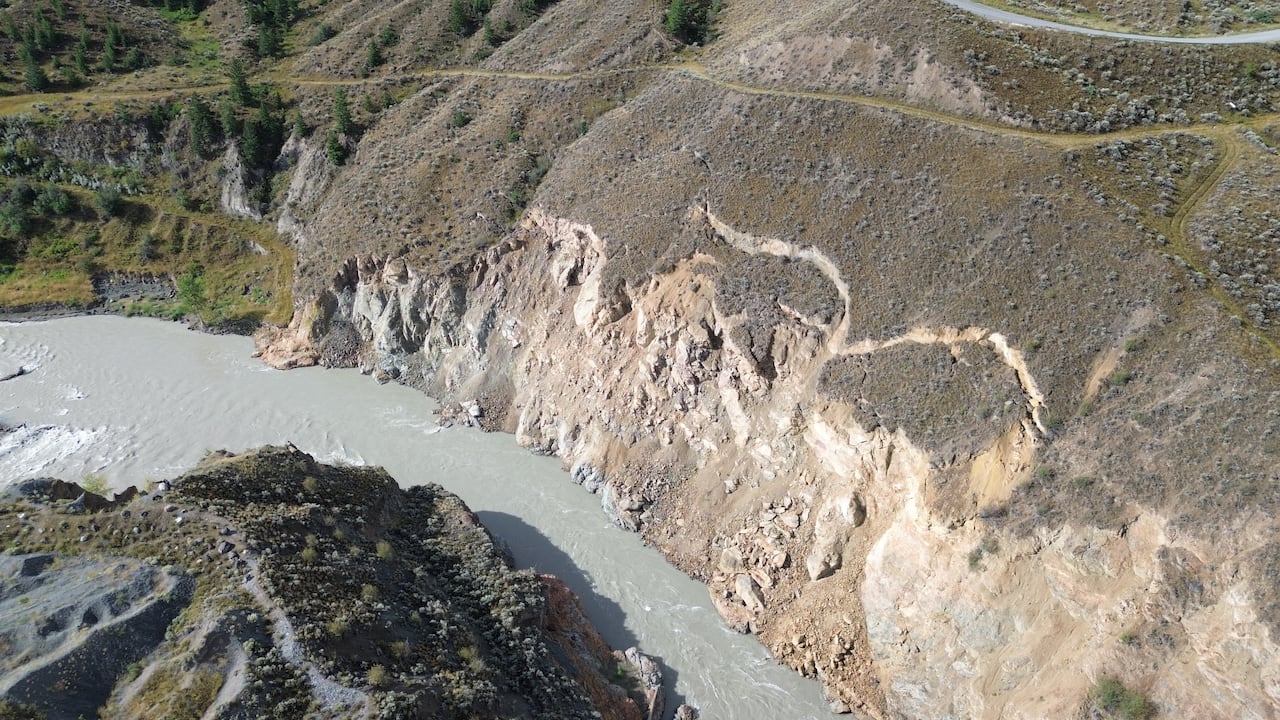 Visible “tension cracks” are seen above the Chilcotin River in this handout image from the Tŝilhqot’in Nation. (Tŝilhqot’in National Government)
In response, the nation says it will pay for the work itself rather than risk “devastating impacts” for salmon, with an estimated cost of up to $3 million.
Williams Lake First Nation has meanwhile announced the creation of its own emergency planning table in response to the landslide risk and what it describes as “continued inaction” on the part of the B.C. and federal governments.
“For months, we have called on the province and [Fisheries and Oceans Canada] to work with us to plan for this risk, and to protect salmon, people, and our cultural heritage. That has not happened,” Chief Willie Sellars says in the Jan. 13 statement.
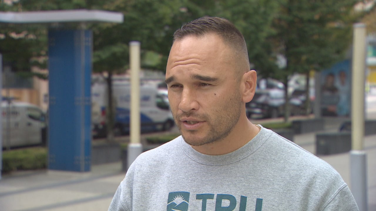 Williams Lake First Nation Chief Willie Sellars says his nation has convened an emergency planning table in light of the landslide risk. (CBC)
Assessments have confirmed the slope could fail, the nation says, posing safety risks and potentially damaging cultural and archeological sites.
A statement from B.C.’s Ministry of Emergency Management says it recognizes the “enormous value” of the local salmon fishery and cultural heritage along the Chilcotin River for Secwépemc and Tŝilhqot’in and communities.
The province “worked side-by-side” with First Nations and groups including the First Nations Fisheries Council during the initial response to the slide “to ensure that their expertise was connected directly into the emergency operations teams,” it says.
WATCH | Damage from July 2024 slide: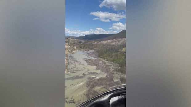
Aerial footage shows damage from Chilcotin River landslide
Footage shared by Williams Lake First Nation Chief Willie Sellars shows the aftermath of a landslide in the B.C. Interior that has blocked a major river tributary, prompting evacuations and flood warnings.
The Department of Fisheries and Oceans Canada says in an emailed statement that it recognizes the importance of protecting salmon, public safety and Indigenous rights.
“While DFO does not have a lead role in emergency preparedness or landslide risk mitigation, the department is engaged where fish and fish habitat are affected,” it reads.
“DFO will continue to engage with Indigenous partners and other governments, as appropriate, to share information and support co-ordination within its mandate.”
WATCH | Flash flood risk was highlighted during 2024 slide:
Landslide blocking B.C. river could give way causing flash floods, officials warn
The Tŝilhqot’in National Government has declared a local state of emergency after a landslide blocked the Chilcotin River in British Columbia’s Cariboo region.Nation claims it was left out
Sellars also says his community has been left out of the emergency task force convened by the Tŝilhqot’in government in response to the July 2024 slide.
“We have tried to work collaboratively with the Tŝilhqot’in National Government, but those efforts have been thoroughly rebuffed,” Sellars says.
“Out of necessity we have created the Secwépemc Chilcotin River Emergency Table. We need to carefully plan and act now in advance of a disaster.”
A spokesperson for the Tŝilhqot’in National Government did not directly respond to a question about the claim it had rebuffed the other nation, only to say its press release expressing concern about the lack of government action spoke for itself.
The statement issued Jan. 15 says the nation has engaged provincial and federal authorities to start permitting for its planned mitigation work, which is set to include manual scaling and targeted trim blasting along the slope in question.
The stabilization plan was developed by the emergency task force that includes provincial and federal representatives, among others, the nation says.
WATCH | River breaches landslide: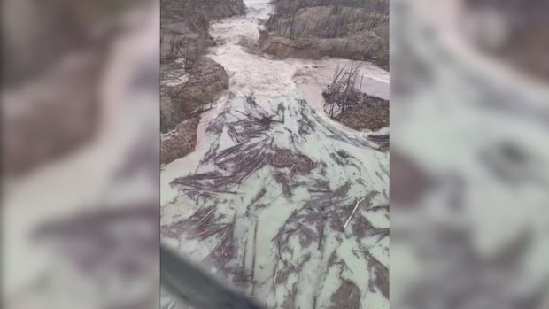
Debris flows in B.C. river after water buildup bursts through landslide
Footage shot by Trevor Chelsea from a helicopter shows the Chilcotin River flowing with significant force on Monday, nearly five days after a landslide dammed the river and caused a significant buildup. CORRECTION (Aug. 6, 2024): A previous description said the footage was shot Tuesday; in fact, it was Monday.
The Tŝilhqot’in government is “fully committed to consulting all impacted First Nations along the Fraser River who depend on these salmon,” it adds.
The statement from Williams Lake First Nation says all Secwépemc communities have been invited to participate in the newly formed planning table, and invitations would also be extended to the province, Ottawa and the Tŝilhqot’in National Government.
Stswecem’c Xget’tem First Nation Chief Hank Adams expressed support for the table, saying it brings the nations together to plan ahead of a “preventable disaster.”
“The rights and title of the Secwépemc … at Farwell Canyon continue to be ignored, and that must change,” Adams says in the statement.
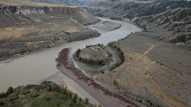
The slide in July 2024 happened about 22 kilometres upstream from the Farwell Canyon bridge, not far from the confluence of the Chilcotin and Fraser rivers.
It dammed the Chilcotin River for several days, triggering flood warnings and evacuation orders for areas near the waterways.