
![]()
Listen to this article
Estimated 2 minutes
The audio version of this article is generated by AI-based technology. Mispronunciations can occur. We are working with our partners to continually review and improve the results.
Islanders in central and eastern parts of the province could be in for more messy weather Sunday evening and into Monday afternoon.
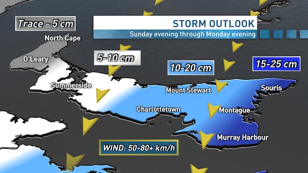
Environment Canada issued a special weather statement for Queens and Kings counties warning of significant snowfall and strong winds.
The statement says the most eastern regions of Kings County can expect 10 to 20 centimetres of snowfall with northeasterly wind gusts at 60 to 80 kilometres per hour.
“Travel conditions will gradually deteriorate Sunday evening due to accumulating snow, strengthening winds and blowing snow,” the statement reads, warning utility outages are possible.
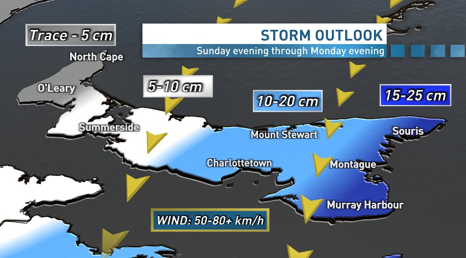 Islanders in impacted areas can expect 10 to 20 centimetres of snowfall. (Jay Scotland/CBC)
CBC P.E.I. meteorologist Jay Scotland said Friday that the latest projected path keeps the worst of the storm to the south and east of the province.
If that path holds, he said western areas of the province could avoid significant snowfall but northeasterly to northerly wind will likely cause blowing and drifting snow in that area.
“Islanders should prepare for messy roads and poor visibility Sunday night through Monday afternoon,” Scotland said.
Blizzard conditions are possible, he said, and wind gusts could range from 50 to more than 80 km/h from Sunday night to Monday afternoon.