
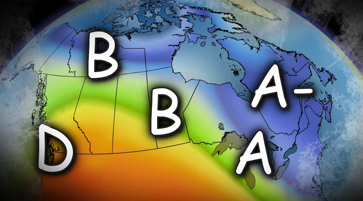
This is a report card grading on a classic, harsh Canadian winter (so far).
Spoiler alert: You’ve only earned an A if you actually felt winter.
DON’T MISS: A major mid-month pattern change will sweep Canada
Canada’s average winter grade: B
Canada’s winter GPA: 2.95
British Columbia: D
When the Grouse Grind opens in February, you know coastal B.C. never really had a winter.
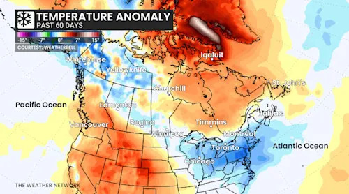
B.C. temperature anomaly past 60 days
Temperature signal: Vancouver is on pace for the warmest winter on record (+2°C anomaly)/
Persistent Pacific ridging and a parade of atmospheric rivers has meant warmth and rain instead of snow along the coast.
The Interior saved the province from a failing grade, with snowpack maintaining resilience inland, but most of the province reported a temperature fever.
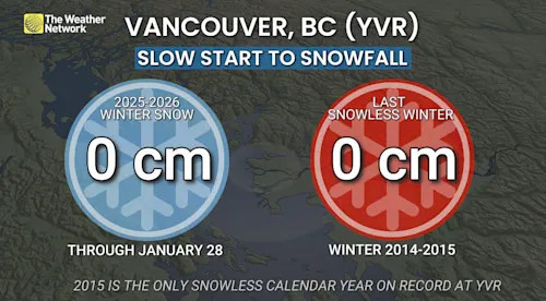
Vancouver airport snowfall 2025-26 winter
Snowfall
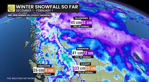
Vancouver: 0 cm (26 cm normal) or zero per cent
Coastal snowpack repeatedly wiped out.
Prairies: B
A wildly split winter so far. Warm west and a cold east. Chinooks dominated southern Alberta while bitter cold hammered Saskatchewan and Manitoba at times.
Western Canada winter 2025-26 temperatures
You can literally see B.C.’s ridge bleeding east, warming Alberta and parts of southern Saskatchewan.
Snowfall check-in:
Edmonton: 72 cm (176 per cent of normal)–a major overachiever
Calgary: 23 cm (70 per cent of normal)
Western Canada winter 2025-26 snowfall
Balanced out, you’ve earned a B.
Ontario: A
Ontario has been Canada’s snow magnet. Cold locked in. Snow came frequently. And this was the quintessential Canadian winter experience.
In fact, southern Ontario wracked up the greatest number of consecutive days below freezing since 2015!
Temperature signal:
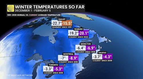
Toronto: -5.3°C (coldest since 2018) Multiple lobes of the Hudson Bay polar vortex dropped south.
Eastern Canada snowfall winter 2025-26
Snowfall:
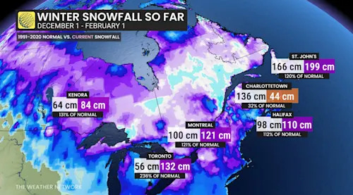
Toronto: 132 cm (236 per cent of normal), the biggest anomaly in Canada
Kenora: 84 cm (131 per cent)
And in the snowbelts? Totals measured in metres.
Quebec: A-
Cold, sometimes stormy, reliably wintry, just shy of an A.
Temperature signal:
Montreal -8.9°C (coldest since 2018)
Quebec is locked into the eastern flank of the Hudson Bay trough and Arctic air.
Eastern Canada temperatures 2025-26 so far
Warmer across central and northern Quebec, keeping you from an A.
Snowfall:
Montreal: 121 cm (121 per cent of normal)
These are strong winter vibes, but absolutely not on Ontario’s level of snow supremacy.
Atlantic Canada: B
Stormy, snowy sections, but snow-starved central Maritimes are dragging your grade down.
St. John’s: 199 cm (120 per cent)
Halifax: 110 cm (112 per cent)
Moncton: 111 cm (83 per cent)
Charlottetown: 44.1 cm (32 per cent): One of the larger snow deficits in Canada.
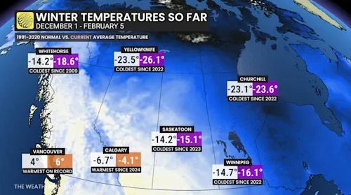
Northern Canada: B
The only thing holding you back from an A is the exceptional temperature anomaly across Baffin Island and Nunavut.
Iqaluit, Nvt., winter warmth 2026
Temperature signal:
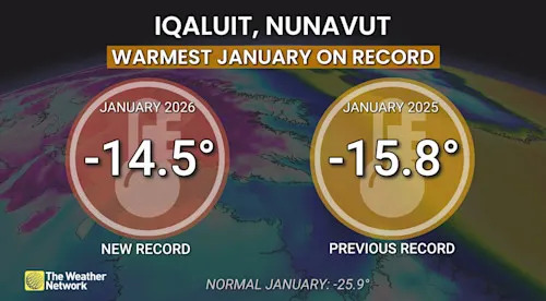
Iqaluit: +7.2°C anomaly, warmest since 2011
Whitehorse: -4.4°C colder than normal, coldest since 2009
Yellowknife: -26.1°C (coldest since 2022)
Snowfall:
Yellowknife: 52 cm (116 per cent)
There you have it.
A respectable interim report card, with a few more weeks of winter to go. Watch for some grade deductions in the final weeks as a thaw spreads across Eastern Canada through the heart of February.