
 Above: City’s report Figure10 shows how various parts of the Vancouver Official Development Plan (ODP) direct growth and eventually become zoning. Any rezoning — for single sites or area-wide — that is deemed consistent with the ODP Generalized Land Use designations map will no longer require a public hearing once the ODP is adopted. See below for more details.
One single Public Hearing scheduled for March 10, 2026 will have far-reaching impacts for generations by reshaping Vancouver into a city of generic tower typologies rather than distinct neighbourhoods. That is, if City Council passes the Official Development Plan (ODP).
Barely anyone knows about the Public Hearing on March 10, but it’s huge. Please consider writing or speaking to council.
If the ODP is adopted, you will see more changes in Vancouver starting immediately and continue for the plan’s 30-year time window.
One of the most consequential changes embedded in the ODP is procedural (the prohibition of most public hearings).
A focus on more and more towers and large blocky buildings everywhere.
Scrapping of community plans in favour of “one size fits all” approach, citywide.
100,000 land parcels affected in Vancouver, but almost no one has been notified
Population projections courtesy of real estate industry instead of official government numbers.
No concrete plans or funding for added infrastructure like parks, community centres, or schools.
Inadequate protections for renters.
A focus on small expensive units largely beyond the reach of people on median incomes.
Already there has been considerable land assembly as developers and speculators position themselves to take advantage of the ODP, and benefit from reduced oversight by the public and even by Vancouver City Council.
If passed, the ODP will instantly and significantly reduce opportunities for residents to know about and have a say in how their neighbourhoods change. This dramatic change is premised on the Province’s presumption that the public has been adequately consulted in development of the ODP. If you feel that the City has NOT adequately informed you and/or sought your input, even that alone is an important point to convey.
Even with the inflated population projections up to 2050, the amount of development already approved in Vancouver or in the pipeline could be built out by 2034. This would suggest that no additional development actually needs to be approved beyond what is already in the pipeline, making the further development in the ODP a rash move, excessive, undemocratic, and unnecessary.
While the development industry lobbyists and “abundance” activists think it’s great, the provincial and municipal government have not been listening to other voices, like the 30 top professionals with “Housing Reset” (urbanists, planners, architects, and academics) who wrote Vancouver mayor and council calling for them to withdraw the ODP. (See Letter to Vancouver on Official Development Plan (ODP) (link here).
While the City’s planning staff rely heavily on jargon, hampering public understanding of what’s really at play, here below is a summary of key points using maps and images, adapted from a recent post by Brian Palmquist and further added to from a summary slide presentation by Elizabeth Murphy (click to open PDF).
The ODP ignores all of Vancouver’s traditional 22 neighbourhoods, and instead referring to them generically as just seven neighbourhood “types” strewn around the city.
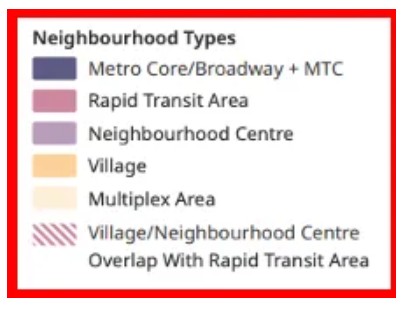 Above: The Vancouver ODP’s seven neighbourhood types.
These seven fuzzy-edged Neighbourhood Types are illustrated as the proposed new Urban Structure Strategy.
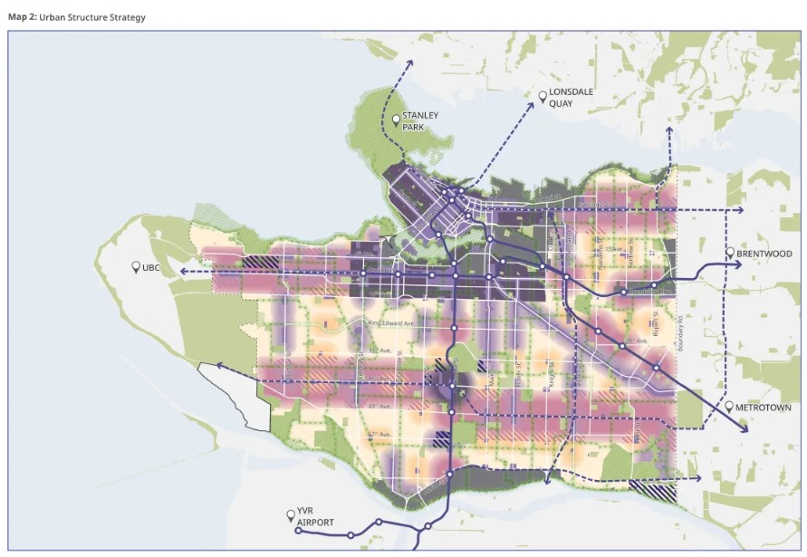
Below: The “Urban Structure Strategy” with vague boundaries based on Urban Growth Strategy in the Vancouver Plan. This map directs the growth to be eventually included in the General Land Use Map that follows this one.
.
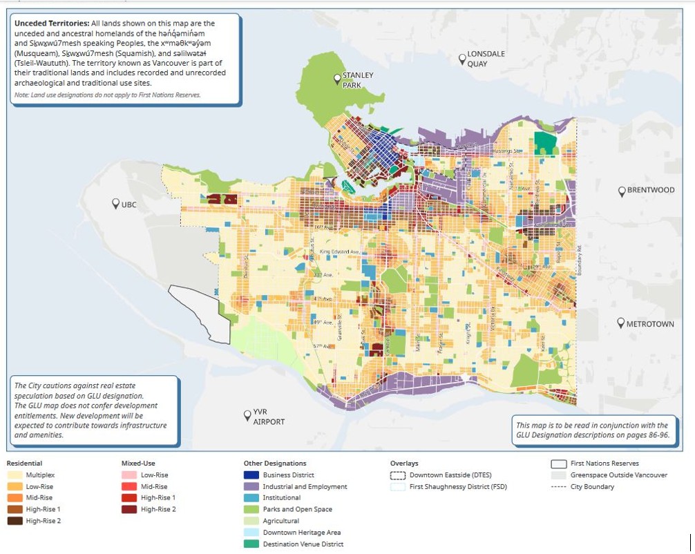
Below: This is the General Land Use Map with the land use designations that could be rezoned without a public hearing if the ODP is adopted.
.
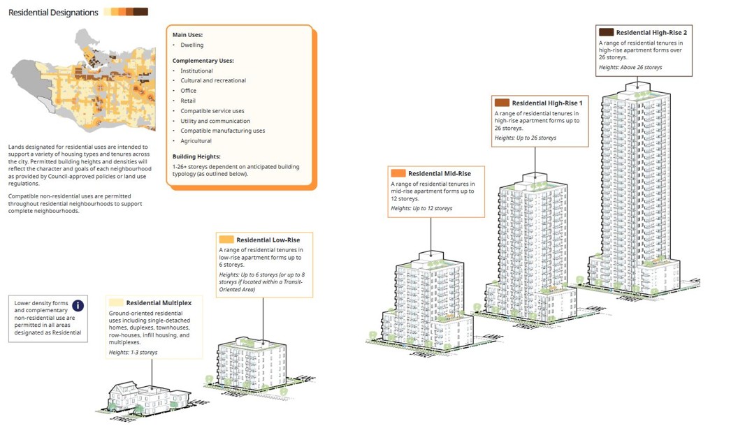
Below: These are the typical housing designations for each zone in the General Land Use Map. Mostly apartment buildings in tower forms of varying sizes.

.
What follows now is a collection of are maps and illustrations of some of the seven neighbourhood types. The light blue in the maps shows where the stated form of development will be permitted if the ODP is approved.
Below: Proposed Rapid Transit Areas include much of Kitsilano (west of Vine, outside the Broadway Plan area) and West Point Grey between 1st and 16th Avenues, as well as most of Cambie, all of 41st Avenue and Hastings Street, and most of the rest of Kingsway.
![]()
.
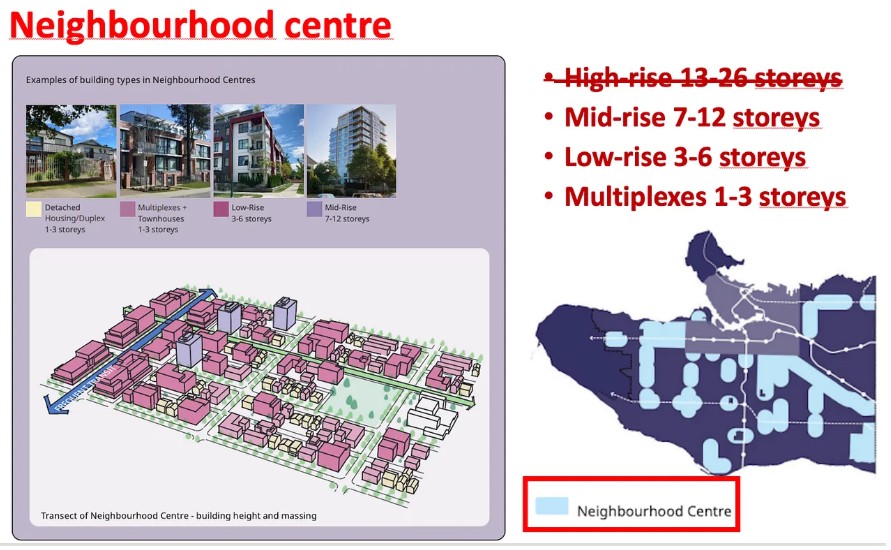
Below: Neighbourhood Centres (up to 12 storeys) include many of the same areas as the Rapid Transit Areas (up to 26 storeys as shown above). This can be confusing.
.
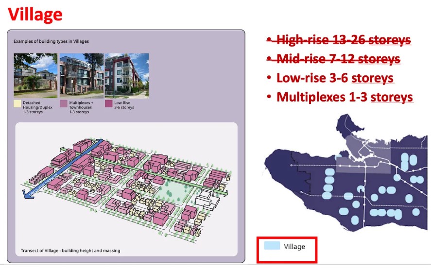
Below: The proposed Villages include 27 areas mostly outside of existing, sometimes struggling neighbourhood shopping areas, as well as some overlaps with more dense areas. Villages have never been clearly defined or explained by City staff. CityHallWatch has noticed aggressive land assemblies by numbered companies already in these areas. As soon as the ODP is passed, Council plans to incorporate these villages into the ODP, thereby removing most opportunities for meaningful public involvement in future decisions.
.
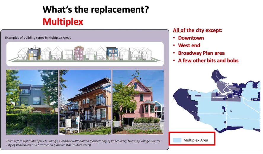
Below: “Multiplexes” can already be built almost anywhere in the city, but the ODP will further embed them in policy and increase the area covered. See our recent post “Multiplexes sprouting up in Vancouver. Will the ODP accelerate financialization of our housing?”
.
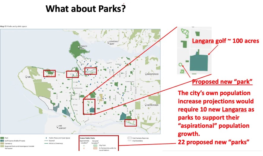
Where will those extra 250,000 or more folks recreate? (note 9) See “Parks” below.
Below: The ODP shows 22 new parks, or slightly less than one per 1,000 new residents. Unfortunately these new parks are mostly tiny and, ironically, distributed to the areas already deemed park rich. The red boxes above show concentrations of “new” parks: Jericho Lands; Riverview district; False Creek; Marpole/Langara. Of greater significance is the miniscule area of these parks. When False Creek South and North and Coal Harbour were developed, they offered the city 2.75 acres of new park per 1,000 population—their legacy is enjoyed by all citizens. If we assume these parks have absorbed all of the city’s growth for the past 40 years or so, and we need to provide new parks at the same ratio, then we need ten Langara golf courses to accommodate the conservative numbers for growth—not 22 micro dots.
.
What about community facilities?
“Over the next 30 years, community facilities will need to respond to a growing, diverse, and changing population. Upgrades and investments are necessary to keep pace with population growth and to ensure equitable access. At the same time, we need to ensure our network of community infrastructure is financially sustainable.” (Pages 142-143 of the ODP) The quote is notable for what it excludes: any spatial or budgetary provisions for community facilities.
What about schools?
Not only failing to present a clear plan to handle the future increase in students, Vancouver’s School Board is in the process of planning to liquidate “surplus sites.” Concerned citizens have struggled through FOI inquiries to get concrete information on VSB plans. For more reading on this, see “Density without classrooms: The growing crisis in Vancouver’s school planning (Downtown and Broadway Plan area analysis” by Melanie Cheng).
*****
More reading
************
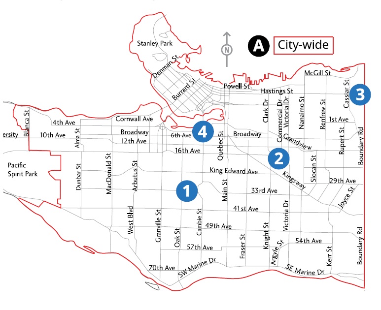
Below is how the March 10 Public Hearing is officially notified on the City’s website. This is evidence that the real implications are not adequately conveyed to the public. At least the map clearly shows that all of Vancouver is affected.
City’s map combining the notification for two public hearings (numbers 1 to 4 for March 5, and the red line indicating the entire City for the ODP on March 10). Not explicitly stated is that the ODP will significantly affect the future on 100,000 land parcels in Vancouver. Residents of any form of tenancy (owner, renter, co-op, etc.) have not been directly notified of the Public Hearing.
PDF posted on City website (location difficult to find)
For the record, here’s what the text says.
Public Hearing:
March 10, 2026
Tuesday, March 10, 2026, at 6 pm to be convened by electronic means with in-person attendance also available in the Council Chamber at Vancouver City Hall, 453 West 12th Avenue, Vancouver, BC. Vancouver City Council will hold a Public Hearing to consider the following matters:
A. City of Vancouver Official Development Plan *
To adopt the Vancouver ODP, by by-law, in accordance with section 562.02 of the Vancouver Charter and to repeal the Regional Context Statement ODP and the Greenhouse Gas Emission Reduction ODP in accordance with section 562(2)(b) of the Vancouver Charter. If enacted, the Vancouver ODP will set out long-term policy for land use and development city-wide over the next 30 years and beyond and will include greenhouse gas emission reduction targets and policies, and an updated Regional Context Statement. The Vancouver ODP is primarily a land use plan:
directing the location, type, and intensity of different types of land uses, such as residential, mixed-use, industrial, and institutional;
establishing a vision for the transportation network for the movement of people and goods;
identifying the type, extent, and location of parks, open space and natural areas, and establishing a vision for a connected ecological network; and
informing the planning of infrastructure and amenities needed to serve growth.
The ODP will guide future land use policy development and all rezoning applications will be reviewed for consistency with the ODP.
FOR MORE INFORMATION ON THESE REZONING APPLICATIONS, VISIT shapeyourcity.ca/rezoning AND REFER TO THE REFERRAL REPORT OR LEGAL DESCRIPTIONS OF SUBJECT PROPERTIES.
* FOR MORE INFORMATION ON THE “CITY OF VANCOUVER OFFICIAL DEVELOPMENT PLAN” VISIT shapeyourcity.ca/odp
ODP Referral Report Summary by Elizabeth Murphy.