
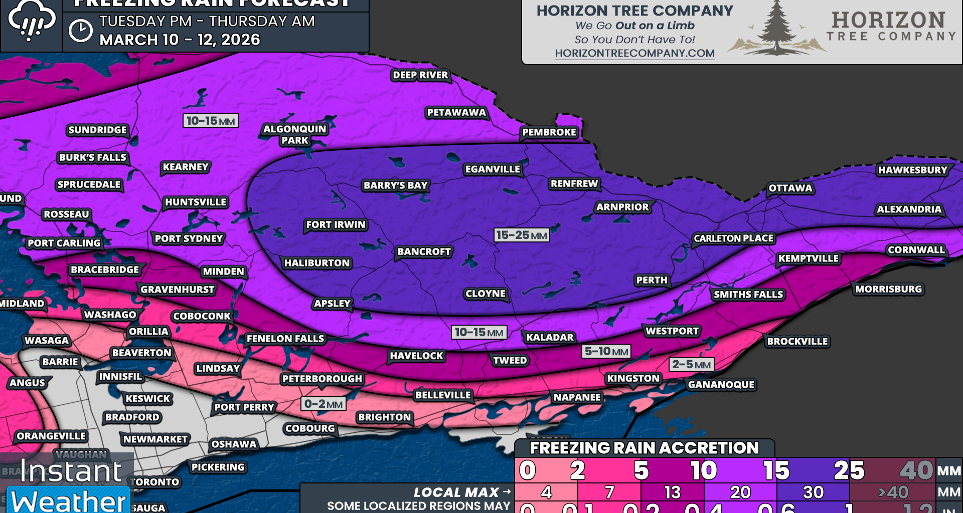
The hardest hit regions for freezing rain are expected to encompass a large portion of Eastern Ontario along the Quebec border and into the Ottawa Valley. In these areas, total ice accretion is likely to range from 15 to 25mm with localized amounts approaching 30mm.
That includes Ottawa, Hawkesbury, Alexandria, Carleton Place, Perth, Arnprior, Renfrew, Cloyne, Bancroft, Haliburton, Barry’s Bay and Pembroke.
However, keep in mind that actual surface accretion may end up somewhat lower since a large portion of the precipitation will fall during a short timeframe. Some of it may drip off surfaces before it has time to fully freeze when it arrives in heavy bursts.
Another major factor will be whether any areas are able to briefly climb above the freezing mark during the afternoon before the arrival of the second wave of precipitation. If that occurs, some of the earlier ice could melt away and make the second round far less efficient when it comes to additional ice accretion.
That is why this event could easily end up being far less damaging than currently forecast if temperatures trend just slightly warmer. There is often very little middle ground when it comes to ice storms, which is why there is such a tight gradient in our forecast ice totals.
Current projections suggest around 10-15mm of ice for northern sections of Central Ontario, including Parry Sound, Burk’s Falls, Huntsville, Algonquin Park and Deep River. This also extends into the Northern Bruce Peninsula. The slightly lower ice totals are due to temperatures potentially rising near Georgian Bay before the arrival of the second round of precipitation, along with the possibility of ice pellets mixing in farther north.
A similar situation may occur just south of the core ice storm zone, including Apsley, Kaladar, Smiths Falls, Kemptville and Cornwall. We expect the freezing line to eventually reach these areas by the afternoon, shutting off the freezing rain threat and substantially limiting the overall impact compared to locations farther north.
Further south, we are expecting around 5-10mm of ice from Bracebridge through Havelock, Tweed and into Morrisburg. Again, these areas should eventually rise above freezing, which will limit the impact mainly to the morning hours when icing is most persistent.
Across the Midland and Gravenhurst to Fenelon Falls corridor extending eastward toward Brockville, freezing rain should be more brief, primarily during the morning hours, leading to roughly 2-5mm of icing at most. We may also see around 2mm of icing in the higher elevations of the Dundalk Highlands, including Orangeville and Shelburne and extending into the Blue Mountains, although it remains uncertain if temperatures will be cold enough here for significant icing.
Very little icing is expected once you reach Lake Simcoe and areas stretching toward Kingston along the Lake Ontario shoreline. This includes Orillia, Lindsay, Peterborough and Belleville. There may be a brief one to two-hour window of freezing rain early in the morning, but temperatures should quickly rise above freezing. Less than 2mm of ice accretion is expected.