
A high-speed stream of solar wind is expected to sweep past Earth tonight (March 13), potentially triggering minor (G1) geomagnetic storm conditions according to NOAA’s Space Weather Prediction Center.
Forecasters say storm activity is most likely March 13-14, with elevated geomagnetic conditions possibly lingering into March 15 as the fast solar wind stream continues to buffet Earth’s magnetic field.
Article continues below
You may like
Where can I see the northern lights tonight?
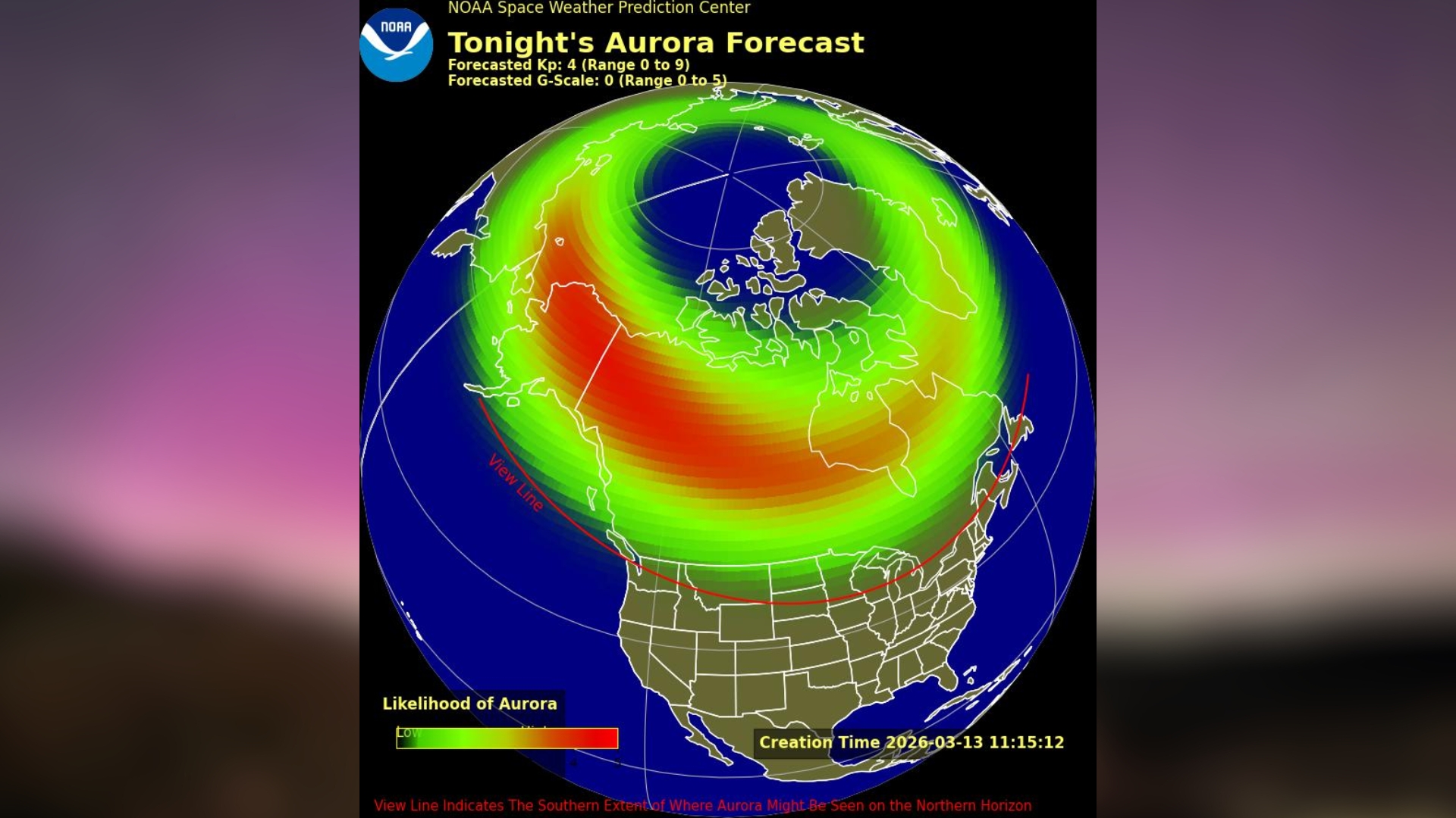
Aurora view line map for tonight courtesy of NOAA’s Space Weather Prediction Center. (Image credit: Inset map: NOAA Space Weather Prediction Center, background graphic added in Canva Pro.)
Based on the latest NOAA aurora forecast map, the following 9 U.S. states appear fully or partially above the possible aurora view line:
AlaskaNorth DakotaMinnesotaMontanaSouth DakotaWisconsinIdahoWashingtonMaine
But remember, auroras can be difficult. The list is based on current forecast data at time of publication, but if conditions strengthen, northern lights could reach much farther south than expected. Equally, if conditions don’t align, we could end up with no auroras at all.
Northern Hemisphere aurora forecast courtesy of the U.K. Met OfficeWhen is the best time to look for the northern lights tonight?
If the skies are clear, you can look out for the northern lights as soon as it gets dark, as geomagnetic activity is forecast to become elevated around 11 a.m. EDT (1500 GMT) and remain elevated into the night.
According to NOAA’s 3-day forecast, possible geomagnetic storm activity is expected to be best at the following times:
Swipe to scroll horizontally
EDT
GMT
Activity
11 a.m. – 2 p.m.
1500-1800
Minor (G1) geomagnetic storming possible
8 p.m. – 11 p.m.
0000-0300 (March 14)
Minor (G1) geomagnetic storming possible
How can I see the northern lights from where I live?
If you’re in one of the 9 U.S. states where auroras might make an appearance tonight, a little planning can go a long way toward improving your chances of seeing them.
Start by finding a location with an unobstructed view north, preferably someone dark and well away from city lights. The clearer your view of the northern horizon, the better.When you’re set up, start scanning the sky with your phone’s camera, as they are usually good at picking up faint auroral glows that aren’t immediately obvious to the naked eye. This helps you identify where activity might be starting and where you should be focusing most of your attention.Dark adaptation is crucial and often overlooked when aurora chasing. If you can, give your eyes at least 30 minutes to fully adjust to the dark so you can better detect subtle auroral features. Keeping in mind that even a quick glance at a bright light or a phone screen can reset the process, forcing you to start over.Dress for the occasion. Aurora shows can be unpredictable and if conditions look promising, you may find yourself standing outside for a while. Make sure to wear plenty of warm layers!
We recommend downloading a space weather app that provides aurora forecasts based on your location. One option I use is “My Aurora Forecast & Alerts,” available for both iOS and Android. However, any similar app should work well. I also use the “Space Weather Live” app, which is available on iOS and Android, to get a deeper understanding of whether the current space weather conditions are favorable for aurora sightings.
Want to capture the perfect northern lights photo? Our how to photograph auroras guide can help.
Editor’s Note: If you snap a photo of the northern or southern lights and would like to share it with Space.com’s readers, send your photo(s), comments, and your name and location to spacephotos@space.com.