
![]()
Listen to this article
Estimated 3 minutes
The audio version of this article is generated by AI-based technology. Mispronunciations can occur. We are working with our partners to continually review and improve the results.
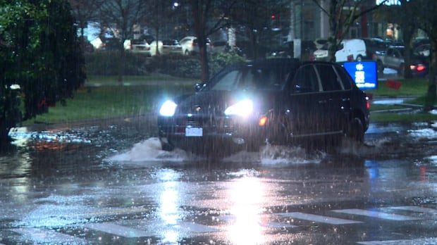
Environment Canada says it’ll be another rainy day for parts of B.C.’s coast on Tuesday.
Rainfall warnings have been announced for several areas, including on Vancouver Island and along the Central Coast, as part of a “prolonged atmospheric river event.”
Environment Canada said total rainfall could reach 200 millimetres on western Vancouver Island between Tuesday morning and Wednesday morning, and the heavy rain could increase the risks of flooding or landslides.
The weather agency said rain will intensify Tuesday afternoon and become heavy overnight.
Northern sections of inland Vancouver Island could also get total rainfall amounts of up to 150 mm.
Meanwhile, the Central Coast, south of Bella Bella, is expected to get 30 mm of rainfall Tuesday.
“Localized flooding is likely. Some roads may become impassable,” Environment Canada said.
Parts of Metro Vancouver and the Fraser Valley are also under rainfall warnings with up to 100 mm of rain expected in the Valley and up to 120 mm in Metro Vancouver from Tuesday afternoon to Wednesday morning.
A special weather statement has been issued for the North Columbia, Kinbasket and West Columbia regions, as well as the Trans Canada Highway (from Eagle Pass to Rogers Pass) and the Arrow Lakes, Slocan Lake and Kootenay Lake, where Environment Canada says a mix of snowmelt and rain could lead to flooding in low-lying areas.
Up to 45 mm of rain is expected to fall there by Wednesday afternoon, with more in the forecast from Thursday afternoon to Saturday.
Whistler and the Sea-to-Sky Highway remain under a winter storm warning, and up to 80 mm of rain is expected to fall from Tuesday morning into Wednesday.
Environment Canada said heavy rain on top of fallen snow could lead to flooding.
“Prepare for quickly changing and deteriorating travel conditions. Allow extra time for travel.”
Potential for ‘very high’ stream flows
Jonathan Boyd, a hydrologist with the province’s River Forecast Centre, said the latest modelling indicates the worst of the weather is expected to hit around Thursday or Friday.
“It’s very unusual to have an atmospheric river go beyond about three days,” he told CBC’s The Early Edition Tuesday morning.
Boyd said the “tremendously impactful” 2021 atmospheric river lasted up to about 72 hours, depending on the location where it hit.
But this current atmospheric river event could amount to five days of continuous rainfall in some sections of the South Coast, according to Boyd.
“We’re keeping our eyes out and the potential is for some very high flows for Thursday [and] Friday.”
Brian Proctor, a meteorologist with Environment Canada, said weather stations across the province have seen “some copious amounts of precipitation.”
The highest precipitation so far has been on the Central Coast in the Rivers Inlet area at Cathedral Point, which has received 199.2 mm of precipitation since Sunday night, according to Proctor.
He said the rain is beginning to ease on the Central Coast and is settling southwards, mainly along the west side of Vancouver Island and, potentially, in the Whistler area.
Proctor said most areas of Metro Vancouver won’t see “rainfall warning” levels of rain, but precipitation will be pronounced along the North Shore Mountains and, potentially, into the Fraser Valley.