
Conservation Sudbury’s flood warning reflects rising waters amid today’s warm weather and a rain event forecast for Saturday
As warm weather continues to beat down snowbanks and up to 30 mm of rain forecast to fall overnight, Conservation Sudbury has expanded their flood warning.
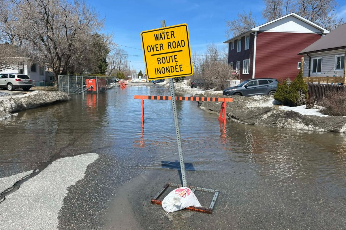
“Water levels, which are already high in many places, are anticipated to continue rising,” Conservation Sudbury said in a media release issued at 6 p.m. on April 17.
“Specifically, areas within the floodplain of the Whitson River in Val Caron and the Belanger St. area in Chelmsford, Larchmont Dr, areas in the vicinity of Grassy Lake and low-lying areas in the community of Dowling. Low-lying areas previously identified, such as those along Junction Creek and Lily Creek could also see further increases in water levels. Residents within these areas should prepare accordingly.”
The updated flood warning is to remain in effect until 2 p.m. on April 22, with a flood warning applying “where flooding is imminent / already occurring.”
Daytime highs of 14 C were forecast for Friday, and Saturday’s highs are forecast at 9 C, after which conditions will cool for a few days while retaining above-freezing temperatures.
The area of flooding is anticipated to exceed that seen locally in the spring of 2023.
The following warnings are in effect, as described by Conservation Sudbury:
Flood Warning for Whitson River – Val Caron: The Whitson River in Val Caron continues to rise, though the rate has slowed to approximately 8 cm per day. Water levels will rise further as a result of the warm weather and rain in the forecast into Saturday. If water levels rise above the banks of the river, residents located within the floodplain should prepare accordingly.
Flood Warning for Whitson River – Chelmsford: The river continues to rise at a rate of about 63 cm per day. Residents near Belanger Street should be prepared to leave if required.
Flood Warning for Vermilion River – Larchmont Drive: The river continues to rise at a rate of about 51 cm per day. The road is already closed and water levels will continue to rise. At the current rate of rise, the road could eventually have more than 1 m of water over it in areas. The flooding in this area is expected to last a week or more.
Flood Warning for Vermilion River – Centennial Park to Grassy Lake Road vicinity: The river continues to rise at a rate of 32 cm per day. Water is currently over roads in the Grassy Lake area and will continue to rise. The flooding in this area is expected to last a week or more.
Flood Warning for Onaping River – Dowling: The river continues to rise at a rate of 16 cm per day. This rate of rise is anticipated to continue or increase in the coming days, as runoff from the large snowpack in the north starts to make its way through the watershed. Residents in low-lying areas should prepare accordingly.
Flood Warning for Junction Creek: Junction Creek levels continue to be elevated from rain and runoff earlier in the week. Water levels are anticipated to increase further over the weekend in response to the rain.
“Overland flooding is already occurring in numerous low-lying areas and water levels continue to increase,” Conservation Sudbury noted. “Residents in flooded areas should remain on alert, including parts of the Flour Mill adjacent to Junction Creek, the Nickeldale neighbourhood north of the Ponderosa wetland, Charlotte Street adjacent to Junction Creek, Beverly Drive near Lily Creek, areas of Coniston adjacent to Romford Creek, areas adjacent to Moose Creek in Wahnapitae.”
They also caution people to “exercise extreme caution around local waterways.”
On a similar front, the City of Greater Sudbury has urged people to stay off the ice.
“Ice is not safe for walking, snowmobiling, ATVs or pets. Keep yourself, and your four-legged companions, on solid ground,” they noted on social media. “No ice is without risk. Stay safe, stay informed and protect yourself and others.”
As of 4:45 p.m. on April 17, the city listed the following roads as being closed:
Larchmont Drive (Chelmsford)
Mikkola Road (from Bonnie Drive to Kantola Road, Lively)
Simmons Road (Bridge section, Chelmsford)
Kauppi Road (Wahnapitae)
Molly’s Road (Wahnapitae)
Johnson Road (Worthington)
Boundary Road (Whitefish)
Caruso Street (Coniston)
628 Red Deer Lake Road North (Wahnapitae)
Meanwhile, municipal crews and contractors are working to clear catch basins and are urging residents to submit flood concerns to the city’s customer service line by phoning 311 or by using the online service portal by clicking here