
Breadcrumb Trail Links
Sarnia farmer Mark Lumley calls it the “big green blob.”
Published May 13, 2026 • Last updated 7 hours ago • 4 minute read
 Sarnia planning manager Eric Hyatt speaks at a public input meeting on the city’s draft zoning bylaw May 11, 2026. (Tyler Kula/ The Observer)Article content
Sarnia farmer Mark Lumley calls it the “big green blob.”
Advertisement 2
This advertisement has not loaded yet, but your article continues below.
Article content
The “natural environment” zone in Sarnia’s latest zoning bylaw draft is drawing attention from people concerned about its implications for their property rights.
Article content
Recommended Videos
Article content
Sarnia Mayor Mike Bradley called a special meeting of council Monday to hear concerns.
About 15 people offered input on the subject, and other matters outlined in the zoning document that’s been in the works since shortly after Sarnia approved its official plan in 2022.
What is the ‘big green blob?’
Sarnia’s zoning bylaw draft includes a series of maps showing zoning for all sectors of the city, including the new natural environment zone.
The zone, planning manager Eric Hyatt said, uses St. Clair Region Conservation Authority mapping data that flags areas where flooding and other natural hazards may be present, and requires conservation authority evaluation before the city grants building approvals.
The natural environment zone, or blob, goes a step further by also identifying natural features like significant woodlands and wetlands, as identified in city and County of Lambton official plans.
Advertisement 3
This advertisement has not loaded yet, but your article continues below.
Article content
Construction in those areas can happen, and has happened before, but requires environmental impact studies and site-specific exemptions for development to go ahead, Hyatt said.
Why create the natural environment zone?
Creating the zone isn’t actually adding anything new, Hyatt said.
Making it part of the new zoning bylaw is about letting landowners interested in building in hazard and natural heritage zones know “there may be some limitations here,” he said.
To obtain a building permit, for natural heritage areas, the bylaw requires an environmental impact study and application to the city. Consultation with the conservation authority is needed for natural hazard lands where the conservation authority is in charge.
Chris Carter, the city’s chief administrator, said it’s so people don’t come asking for building permits, only to be surprised other steps are involved.
“All we’re trying to do is take (the conservation authority) map and combine it with our map, so when someone comes in they have a complete document,” he said.
Advertisement 4
This advertisement has not loaded yet, but your article continues below.
Article content
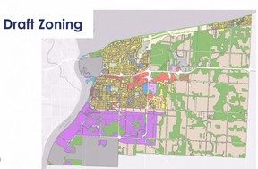 The overall zoning map for the City of Sarnia, as per its current zoning bylaw draft. Areas in green are part of a natural environment zone. (Screenshot)So what’s the problem?
Lumley, who farms off Confederation Line, in a section of the blob, said he’s built on his land there before without objection from the conservation authority.
He’s worried the city flagging the potential for conservation authority concern, could result in increased scrutiny.
The conservation area maps already exist for people to consult if they’re in a flood plain or other natural hazard area, he said.
When it comes to the green blob, Sarnia should “get rid of it and allow the other higher tier . . . levels of government to do their work.”
Kevin Forbes, who also farms in a section of the natural environment zone, said he’s concerned about how the new zoning might restrict his operation.
“It does concern me, changing the zoning of my property, that it has the potential to impact the operation of my farm in the future,” he said.
Mike Belan and Brian Eves, with the Lambton Federation of Agriculture, expressed similar concerns about unforeseen impacts.
Advertisement 5
This advertisement has not loaded yet, but your article continues below.
Article content
They noted Sarnia is home to 2,140 farms, employing about 7,400 people.
Sarnia resident Lou Longo said the new zoning adds to the area on his 0.8-hectare property where he needs studies and permission to build.
“This seems like expropriation without compensation — taking away all my property rights and not allowing me to do anything on my lot,” he said.
There are already other checks in place, he said, arguing the natural environment zone is overreach.
Are there other concerns?
Previously flagged issues like allowing more flexibility for commercial development in city sectors like south of Confederation Street and Confederation Line have been addressed, and the changes city staff have made drew praise from Longo and others.
A new supportive housing definition and specifications for parking — a minimum of two spaces, plus 0.5 spaces per unit — drew some comments about the need for more specificity about types of supportive housing, and it’s potential to go almost anywhere in the city.
Advertisement 6
This advertisement has not loaded yet, but your article continues below.
Article content
There were also concerns expressed from nuSarnia Foundation spokesperson Douglas Gray that the rules around lot frontages for triplexes and fourplexes, parking minimums for affordable housing, and other restrictions for additional residential units, are all too strict to help Sarnia achieve its intensification and infill goals, that are part of the official plan.
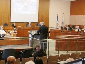 A public input meeting on Sarnia’s draft zoning bylaw was held in council chambers May 11, 2026. (Tyler Kula/ The Observer) jpg, SO, apsmcHow we got here
Sarnia approved its official plan in 2022 and the zoning bylaw that implements the official plan has gone through four drafts until now, adjusting for provincial rule changes and public feedback.
Changes include adding more flexibility for housing options, relaxing parking requirements, and eliminating certain requirements to help spur development, Hyatt said.
What the St. Clair Region Conservation Authority is saying
Asked how current the conservation authority’s mapping data is, spokesperson Donna Blue said it’s reviewed annually, and revised as needed by provincial regulation.
Advertisement 7
This advertisement has not loaded yet, but your article continues below.
Article content
“The SCRCA mapping was updated in 2024 to reduce the regulated setback form provincially significant wetlands to 30 metres from the previous 120 meters, based on the updates from the provincial government with respect to Ontario Regulation 41/24,” she emailed.
The last major updates to the regulated area were in 2006, 2009 and 2011, she said.
What’s next?
A city staff report incorporating public feedback is expected to come to council for it’s next regular meeting May 25, Sarnia Mayor Mike Bradley said.
Council may decide then to approve the bylaw, or call for more revisions.
A date also hasn’t been set yet for a public meeting to discuss previously announced official plan changes, that need to be passed by council before the zoning bylaw can be implemented.
Lambton County also needs to approve any official plan changes.
“In order to approve the zoning bylaw, once we have a final copy prepared, it would not come into effect until the official plan amendment that is required to implement it is approved by the County of Lambton,” Hyatt said.
Article content
Share this article in your social network