
New evacuation orders issued for Ainslie Creek wildfire near Merritt
Published 1:00 pm Saturday, August 8, 2026
More evacuation orders and alerts have been issued in response to the Ainslie Creek wildfire southwest of Merritt, which as of Saturday (Aug. 8) was estimated at 48,537 hectares.
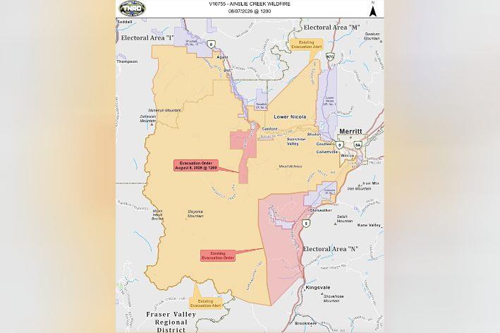
On Saturday, the Thompson-Nicola Regional District (TNRD) issued an evacuation order for approximately 61 addressed properties on the fire’s northeastern flank in Electoral Area “N.” The order includes all addressed properties west of Spius Creek, including Petit Creek Road and Prospect Creek FSR.
On Friday, the TNRD issued an evacuation order for approximately 57 addressed properties in the Coldwater/Patchett area on the Ainslie Creek fire’s southeastern flank. An evacuation alert that was in place was expanded, and now includes a total of 783 addressed properties in Electoral Areas “I,” “M,” and “N.”
In order to receive Emergency Support Services (ESS), evacuees should self-register via the Evacuee Registration and Assistance tool at ess.gov.bc.ca, or report to the Kamloops ESS Reception Centre at McArthur Island (1655 Island Parkway). Anyone who requires transportation from the area should contact the TNRD’s Emergency Operations Centre at 250-377-7188 (toll-free at 1-866-377-7188).
BC Wildfire Service (BCWS) says that there is no imminent threat to Highway 8 from Spences Bridge to Merritt, Highway 5 (the Coquihall), or to the City of Merritt itself.
The northeastern perimeter of the fire is currently estimated to be 11-12 kilometres southwest of Highway 8, and BC Wildfire Service (BCWS) estimates that growth on Saturday will be approximately five kilometres beyond this perimeter to the north and northeast.
The other area of the fire seeing significant growth is on the southeastern flank slightly outside the fire’s perimeter (north of Uztlius Creek). Once this flank gets clean air and elevated winds, the area is expected to see continued aggressive fire behaviour and growth. The closest edge of the current perimeter on this flank is approximately 12-13 kilometres from Highway 5.
For information about the current evacuation orders and alerts issued by the TNRD, go to the TNRD’s Emergency Operations Centre dashboard.
For information about road conditions and highway closures, go to DriveBC.
For information about all wildfires currently active in the province, visit the BC Wildfire Service website.