
Plans for a new Airdrie-West provincial riding remain in Alberta’s latest electoral boundary recommendations, but neighbouring Cochrane and Springbank face a different arrangement that would place portions of Rocky View County into Calgary-area constituencies.
The Independent Advisory Panel on Electoral Boundaries has retained the proposed Airdrie-East and Airdrie-West constituencies recommended by the 2025–26 Alberta Electoral Boundaries Commission.
Related Stories:
Its report, tabled in the legislature Monday, Nov. 2, recommends replacing the earlier proposed Cochrane-Springbank constituency with a smaller Cochrane riding. Springbank would be divided between two Calgary constituencies, while additional Bearspaw subdivisions would become part of a third.
Alberta currently has 87 electoral divisions. The original commission recommended increasing that number to 89 in March, while the latest advisory panel proposes 91.
The recommendations have not been approved by the legislature.
Airdrie-West remains on the proposed map
The creation of Airdrie-West was first recommended in the commission’s October 2025 interim report and retained in its March 2026 final report.
Under that arrangement, the existing Airdrie-East and Airdrie-Cochrane constituencies would be reorganized into three divisions serving the region: Airdrie-East, Airdrie-West and a separate Cochrane-area riding.
Airdrie-West would encompass western portions of the city and neighbouring Rocky View County territory. Its proposed boundaries extend north to Township Road 282 and south to Calgary’s municipal limits, with Highway 772 forming its western boundary. The railway and 8 Street would form portions of the eastern boundary.
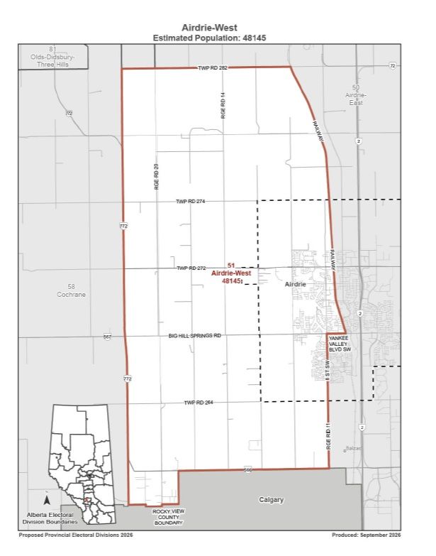 The proposed Airdrie-West electoral division would include western portions of Airdrie and surrounding areas of Rocky View County. The boundaries are recommendations and have not been approved by the legislature. Map / Elections Alberta, Independent Advisory Panel on Electoral Boundaries, 2026.
Airdrie-East would include eastern portions of the city, Crossfield, Irricana, Beiseker and surrounding rural communities.
The March commission also recommended changes outside Airdrie, transferring territory from Airdrie-East to Airdrie-West and High River-Vulcan-Siksika while incorporating areas previously assigned to Olds-Didsbury-Three Hills and Chestermere-Strathmore.
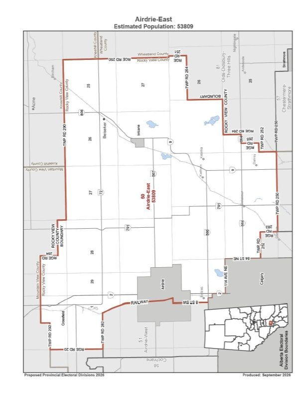 The proposed Airdrie-East electoral division would include eastern portions of Airdrie, Crossfield, Irricana, Beiseker and surrounding areas of Rocky View County. The boundaries remain subject to legislative approval. Map / Elections Alberta, Independent Advisory Panel on Electoral Boundaries, 2026.
The latest panel retained the same estimated populations for both proposed Airdrie constituencies: 53,809 residents in Airdrie-East and 48,145 in Airdrie-West.
Their geographic sizes, however, differ considerably. According to the advisory panel’s population table, Airdrie-East would cover approximately 1,579 square kilometres, compared with 195 square kilometres for Airdrie-West.
The population estimates were developed using the 2021 census and data updated to July 1, 2024, rather than current municipal counts.
Under the proposed 91-constituency map, Alberta’s average population per riding would be 53,722, placing Airdrie-East approximately 0.2 per cent above that figure and Airdrie-West approximately 10.4 per cent below it.
The earlier commission justified Airdrie-West’s smaller population by pointing to anticipated growth in western Airdrie.
In its March report, the commission cited a City of Airdrie submission projecting average annual growth of 4.62 per cent over the following decade, or approximately 5,000 additional residents annually. The city compared that growth to adding an entire town the size of Didsbury each year.
The commission also reported support for the proposed configuration from the City of Airdrie and Town of Crossfield.
Cochrane and Springbank face a different arrangement
The more substantial new regional changes concern Cochrane and Springbank.
In March, the commission recommended creating Cochrane-Springbank, with an estimated population of 56,487.
That proposal would have included Cochrane and much of Springbank, incorporating additional territory from Banff-Kananaskis south of Cochrane, east of Highway 22 and north of the Elbow River.
The latest advisory panel instead recommends a constituency named Cochrane, encompassing the town and surrounding portions of Rocky View County. Its formal population table lists 46,785 residents, approximately 13 per cent below the provincial average.
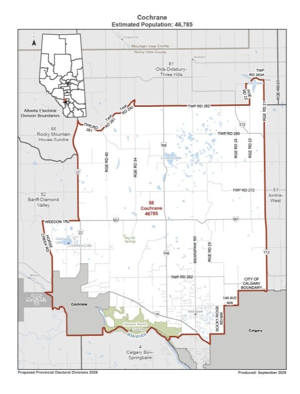 The proposed Cochrane electoral division would include the town and surrounding portions of Rocky View County, with an estimated population of 46,785. The boundaries have not been approved by the legislature. Map / Elections Alberta, Independent Advisory Panel on Electoral Boundaries, 2026.
That is 9,702 fewer residents than the earlier proposed Cochrane-Springbank constituency, although the figures represent different geographic boundaries rather than a direct count of residents being reassigned.
The advisory panel’s report also contains conflicting population descriptions for Cochrane.
Its discussion describes approximately 48,000 residents, or 11 per cent below the provincial average, while the formal table lists 46,785 and approximately 13 per cent below average. The figures are not reconciled in those sections of the report.
The panel’s majority argues that Springbank has stronger connections to Calgary than to Cochrane.
“The connection between Springbank and Cochrane is clearly not as strong as it once was and certainly not as strong as Springbank’s connection to Calgary,” the majority states in its discussion of Calgary-Bow-Springbank.
For its recommendations, the panel defines Springbank as the area bounded by Highway 22 to the west, the Bow River to the north, Highway 8 to the south and Calgary’s municipal boundary to the east.
The Trans-Canada Highway would divide that area between two Calgary constituencies. North Springbank would join Calgary-Bow-Springbank, with an estimated population of 58,673, while South Springbank would become part of Calgary-West-Springbank, with an estimated population of 58,305.
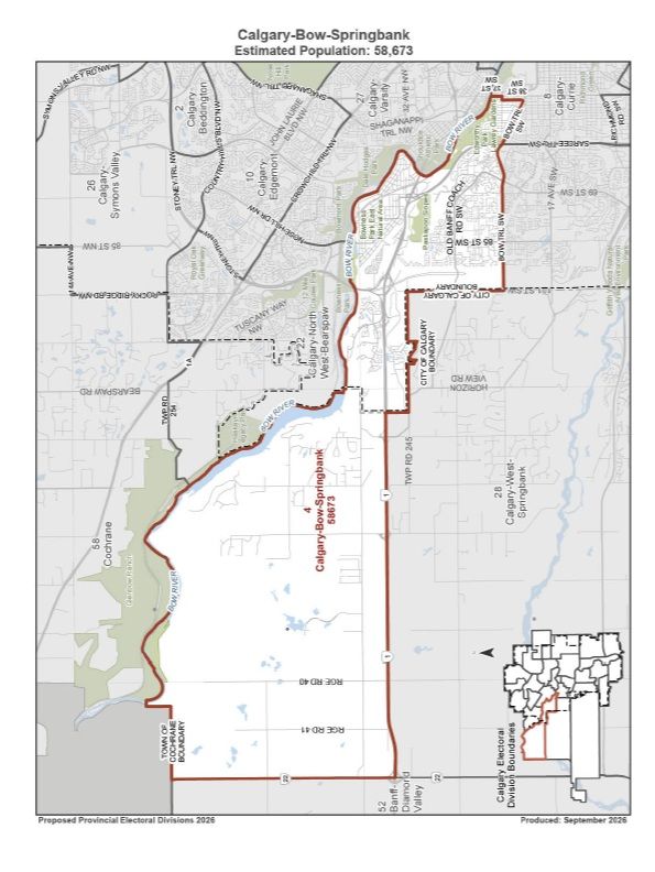 The proposed Calgary-Bow-Springbank electoral division would include the portion of Springbank north of the Trans-Canada Highway. The constituency has an estimated population of 58,673. Map / Elections Alberta, Independent Advisory Panel on Electoral Boundaries, 2026.
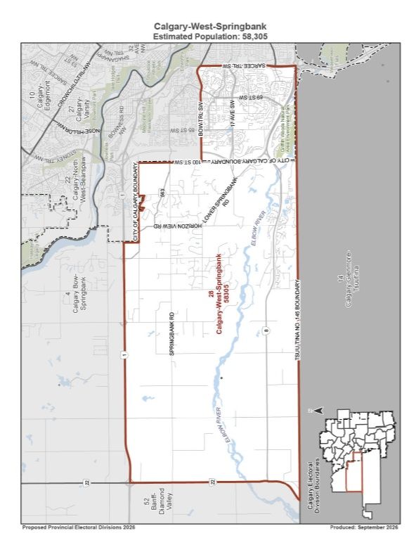 The proposed Calgary-West-Springbank electoral division would include the portion of Springbank south of the Trans-Canada Highway. The constituency has an estimated population of 58,305. Map / Elections Alberta, Independent Advisory Panel on Electoral Boundaries, 2026.
Transportation routes, employment, schools and recreational facilities are among the reasons the majority cites for the change. Its report identifies Springbank Airport, Calaway Park, golf courses and other facilities connecting the community with Calgary.
The panel acknowledges that working farms and ranches remain in Springbank and that some residents maintain stronger connections to Cochrane.
Nevertheless, it maintains that incorporating Springbank into Calgary constituencies would better reflect the relationships between those communities.
Cochrane’s proposed riding would still include surrounding rural territory rather than representing only residents within the town’s municipal boundaries. The majority argues that the arrangement would provide Cochrane with more focused representation while allowing for anticipated population growth.
The possibility of placing Springbank in a Calgary constituency was also examined during the earlier review.
The March commission considered including Springbank in Calgary-Bow but rejected that configuration, citing concerns that the resulting constituency would be too populous.
Commission minority members John Evans and Julian Martin proposed an alternative Calgary-area map that included Calgary-Bow-Springbank, but their recommendations were not adopted by the commission majority.
Springbank currently forms part of Banff-Kananaskis.
Bearspaw could also join a Calgary riding
The latest panel recommends incorporating additional Bearspaw subdivisions south of Highway 1A into Calgary-North West-Bearspaw.
Its report identifies Bearspaw Village and Watermark among communities with connections to northwest Calgary through schools, shopping, transportation and recreation.
Church Ranches, however, was not recommended for inclusion.
The panel acknowledged that Church Ranches and other subdivisions north of Highway 1A also have connections to Calgary but said additional input would have been preferable before expanding the proposed boundaries further.
Calgary-North West-Bearspaw would have an estimated population of 54,361.
The March commission considered moving Bearspaw into Calgary-North West but recommended retaining the existing configuration, citing the absence of a compelling reason for the change.
The latest proposals concern provincial electoral representation, not changes to Rocky View County’s municipal boundaries.
Why was another electoral review undertaken?
The original Electoral Boundaries Commission submitted its final report in March, recommending 89 constituencies.
Its proposed map eliminated Rimbey-Rocky Mountain House-Sundre and Lac Ste. Anne-Parkland as separate electoral divisions while redistributing their territory among neighbouring ridings.
Commission chair Justice Dallas Miller offered an alternative in an addendum.
If the legislature wanted to restore two rural-area seats, Miller proposed increasing the number of ridings from 89 to 91 while limiting changes elsewhere. His Recommendation 5 sought to preserve the commission’s proposed boundaries in Airdrie and electoral divisions containing territory south of the city’s southernmost boundary, except Drumheller-Stettler.
However, the recommendation was Miller’s alone.
Although its wording attributed the proposal to the commission majority, Miller stated in the addendum that his colleagues did not agree with him. Commissioner Greg Clark publicly identified the attribution as a drafting error in April, as previously reported by DiscoverAirdrie.
Miller also acknowledged that some proposals to incorporate Springbank or Bearspaw into Calgary constituencies were not necessarily unreasonable or procedurally unfair. His recommendation did not amount to a categorical rejection of those arrangements.
The Legislative Assembly passed Government Motion 37 on April 21, establishing a legislative committee and directing an independent advisory panel to review a proposed 91-constituency map.
The motion required the panel to incorporate Miller’s recommendation, subject to “any modifications the independent advisory panel considers necessary” while considering effective representation and other specified factors.
That wording is central to the disagreement over how extensively the panel could alter the earlier commission’s proposed boundaries.
The latest review proceeded without a requirement for another round of public hearings. By comparison, the earlier commission conducted public consultations and received 1,147 written submissions following its October 2025 interim report.
The five-member advisory panel was chaired by retired Alberta Court of Appeal justice Brian O’Ferrall.
O’Ferrall, Darwin Durnie and Monte Solberg were nominated by the Premier, while Gerard Kennedy and Brent Robinson were nominated by the Leader of the Official Opposition.
Panel members disagree over boundary changes
Kennedy and Robinson submitted a minority opinion challenging several recommendations made by the advisory panel’s majority.
They supported much of the work to restore two rural constituencies but opposed additional boundary changes south of Airdrie, including the proposed separation of Cochrane and Springbank.
In their minority opinion, Kennedy and Robinson wrote:
“Most importantly, we cannot agree with our colleagues’ other recommended boundary changes to other electoral divisions south of Airdrie.”
The dissenting members argue that some changes exceed the panel’s authority and raise concerns about effective representation. The majority disagrees, maintaining that Government Motion 37 permitted a broader examination of electoral boundaries.
The majority’s report also acknowledges an argument that moving Springbank into Calgary-Bow could favour the governing party.
However, it states that electoral boundary changes can affect election outcomes and that whether the proposed arrangement would produce such an advantage cannot be predicted with certainty.
Separate objections appear in the final report of the legislature’s Select Special Committee on Electoral Boundaries.
NDP MLAs Christina Gray and Kathleen Ganley submitted minority observations questioning the removal of Springbank from the proposed Cochrane riding and the resulting changes to Calgary constituencies. They argue that the new arrangement unnecessarily reduces Cochrane’s population relative to the provincial average.
In a Nov. 2 statement, the Alberta NDP called on the government to abandon the advisory panel’s proposals and adopt the original commission majority’s recommendations.
The legislative committee itself reached a narrower decision. At its Oct. 28 meeting, the committee acknowledged receiving the advisory panel’s report and concluded its review, neither recommending that the proposed boundaries be adopted nor formally rejecting them.
Smith and Nenshi clash over electoral map
The controversy continued in the legislature Monday, with NDP Leader Naheed Nenshi accusing the government of attempting to manipulate the electoral map for partisan advantage.
During question period, Nenshi also claimed Elections Alberta had warned that it would not have sufficient time to implement new boundaries before the next scheduled provincial election.
Premier Danielle Smith defended the process and expressed confidence in the agency.
“I have great confidence in Elections Alberta’s ability to execute on its statutory requirement to hold the election on October 18, 2027, as it is prescribed by law,” Smith told the Assembly.
Smith also cited remarks she attributed to commission member Greg Clark about how additional legislative seats could make the boundary-review process easier.
Those remarks are distinct from Clark’s position in April, when he publicly reiterated his support for the commission majority’s 89-seat recommendations, as previously reported by DiscoverAirdrie.
Nenshi challenged the government’s interpretation of the earlier commission’s work and criticized differences in representation between urban and rural constituencies.
Gray subsequently questioned Justice Minister Mickey Amery about the advisory panel’s work and the absence of another public consultation process. Amery defended the information available to the panel, including public submissions, maps and other material gathered during the earlier commission’s review.
He also emphasized that the legislature would make the final decision.
“It is up to the Assembly to make a final decision on whether the maps are accepted or not,” Amery told the legislature.
Later in the sitting, Amery tabled copies of a letter to Elections Alberta’s chief electoral officer that he said stated the government would not extend the election deadline.
Legislature has final say
The advisory panel submitted its report Oct. 22, and the legislative committee completed its review Oct. 28.
Both reports were tabled Nov. 2, but concluding the committee’s review did not constitute approval of the proposed boundaries.
For Airdrie, the latest recommendations retain the proposed Airdrie-East and Airdrie-West constituencies. Cochrane, Springbank and neighbouring Rocky View County communities, meanwhile, face a different electoral arrangement.
The proposed boundaries remain subject to a decision by the Legislative Assembly.
Listen live to Air 106.1 FM for local news, weather, traffic and community updates throughout the day. Stream us anytime through the DiscoverAirdrie app or online.
Get the facts
Add DiscoverAirdrie as a Preferred Source on Google to see more of our stories in your search.