

Saskatchewan saw unseasonably warm and dry weather last month, with a September that was even warmer than June in some areas, according to Environment and Climate Change Canada data.
Regina, Moose Jaw and Swift Current all recorded higher average daytime highs in September that were warmer than June’s, and across the province, every weather station monitored by Environment Canada ranked the month among the 10 warmest Septembers on record.
“That’s pretty noteworthy,” said Danielle Desjardins, a meteorologist with the federal weather agency. “Every single station we track in Saskatchewan ended up substantially above normal for the month of September.”
While June is typically when summer heat starts to ramp up, this year it was September that sizzled.
In Regina, the monthly mean temperature in September was 15.9 C — well above normal — compared to a slightly below-average 15.7 C in June.
Moose Jaw saw a June average of 15.9 C, and an average of 16.2 C in September.
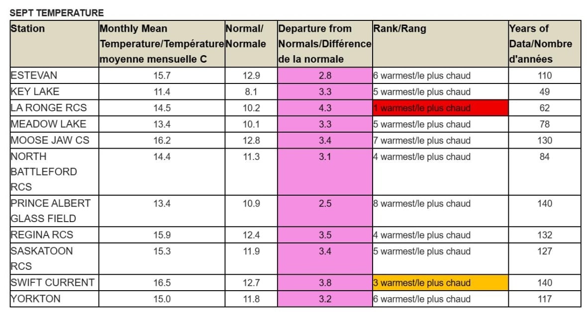
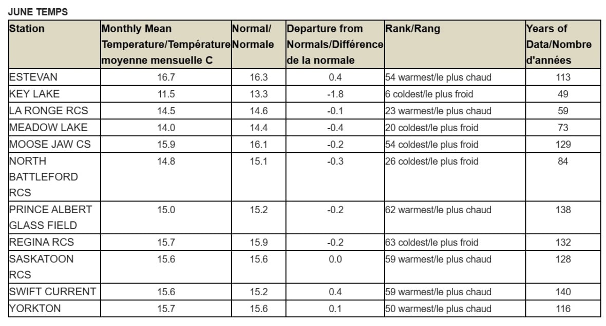 Some parts of the province saw warmer average temperatures in September, shown in the table at top, than in June, shown in the second table. (Environment and Climate Change Canada)
“It’s a little bit of a mix, but I think the story here is the departures from normal,” said Desjardins.
Swift Current breaks 140-year drought record
The lack of rainfall in September was also significant in parts of the province, particularly in Swift Current, which saw its driest September in 140 years of weather tracking, according to Environment Canada.
“They recorded only 0.2 mm of rain for the entire month, whereas the average is 40.6 mm,” said Desjardins.
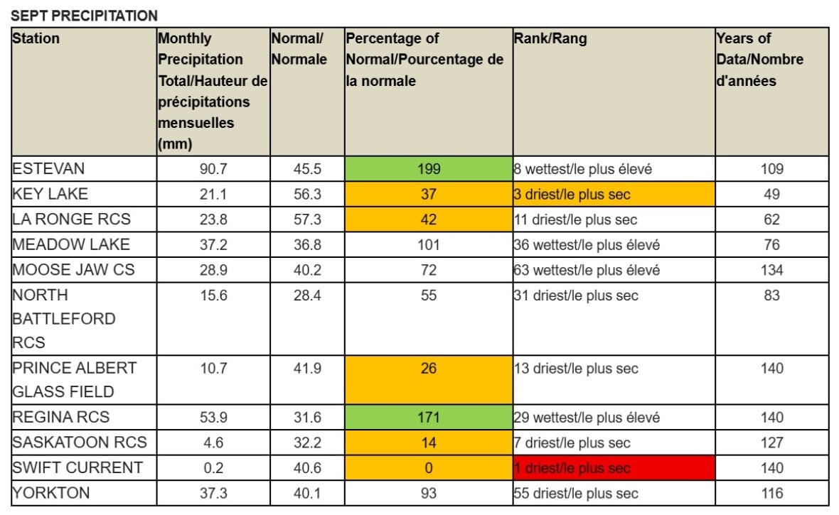 Lat month was particularly dry for Swift Current, which saw its driest September in 140 years of record keeping. (Environment and Climate Change Canada)
The city wasn’t alone either, with other communities seeing little precipitation. Key Lake saw its third-driest September on record, while La Ronge, Prince Albert and Saskatoon also had rainfall amounts that were well below average for September.
“I’m looking at Saskatoon,” Desjardins said. “They only received 14 per cent of their normal precipitation for the month — Prince Albert only 26 per cent.”
What’s causing these swings?
Desjardins points to a persistent upper-level ridge — a high-pressure system in the atmosphere — as the main reason behind last month’s unusual weather.
“It brought in just kind of hot, dry air into almost the entire province,” she said.
Meanwhile, rainfall earlier in the summer — particularly in August, when Swift Current saw more than twice its normal precipitation — was heavily driven by thunderstorms, said Desjardins.
“Thunderstorms are typically very localized in effect, unless you have a really massive low-pressure system that’s tracking through,” said Desjardins. “So you do get a lot higher variability in precipitation amounts in the summer.”
The September heat and lack of moisture may have mixed implications. While drier conditions can help during harvest, Desjardins says it isn’t good for soil moisture recovery.
“I could infer that that would not be good for agriculture,” she said.
The conditions also raise concerns for wildfire risk, especially after a devastating fire season across the prairies earlier in the year.
“The ignition and spread of wildfires is [from] hot, dry and windy conditions, so being hot and dry in the month of September, that has not helped the wildfire situation,” said Desjardins.
Whether last month’s conditions point to longer-term climate trends or were just an anomalous stretch of weather, Desjardins says the data from September speaks for itself.
“The departures from normal in September were pretty substantial.”