
In December 2024, satellites captured an extraordinary phenomenon in the heart of the ocean—waves that soared to nearly 66 feet high. This event, which unfolded during Storm Eddie, shattered records for ocean swells observed from space. But what does this immense power of nature tell us? Using data from state-of-the-art satellites, researchers are peeling back the layers of how massive storm waves move across vast expanses of the ocean.
The Storm That Defied Expectations
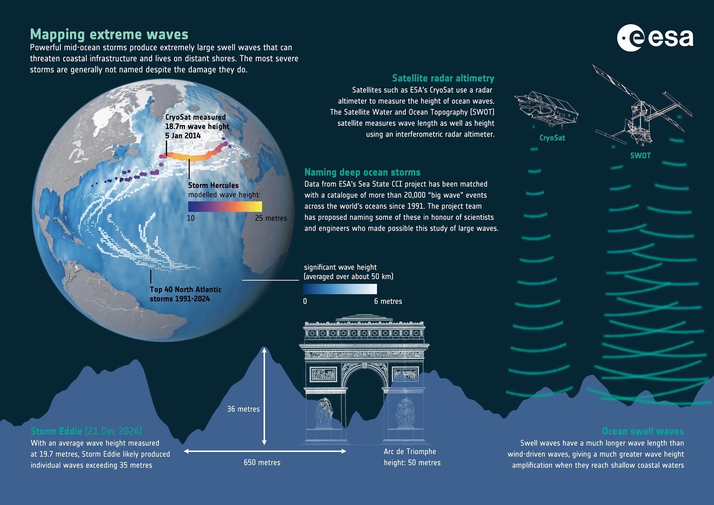
Storm Eddie, a tempest that hit the North Pacific Ocean on December 21, 2024, left behind a trail of massive waves. As the storm reached its peak, satellites like Copernicus Sentinel-6 and SWOT (Surface Water and Ocean Topography) recorded waves as high as 66 feet. This measurement set a new benchmark, marking the highest average wave height ever recorded from space. The data, also backed by decades of previous satellite missions, underscored the potential of these tools to monitor and predict oceanic phenomena with unprecedented accuracy. According to reports from the European Space Agency (ESA), these observations are critical for understanding how massive ocean storms influence marine ecosystems and coastal regions far from the point of impact.
These waves, far from being merely a curiosity, are more than just an oceanic spectacle. They are powerful messengers, carrying critical information about the storm’s size, strength, and movement. Ocean swells, unlike the quick and choppy waves near shorelines, can travel across thousands of miles, maintaining their energy for days or even weeks. The study of these waves—once dismissed as just large ripples—reveals intricate details about their behavior and how they affect the world’s oceans, even if the storm itself never made landfall.
 The Copernicus Sentinel-6 Poseidon-4 dual-frequency (C- and Ku-band) radar altimeter uses an innovative interleaved mode that has improved performance compared to previous satellite altimeter designs. Credit: ESA
Understanding the Energy of Ocean Swells
Ocean swells are born from the winds of powerful storms, but what sets them apart from typical waves is their ability to travel vast distances without losing much of their energy. These swells often act as a time capsule, revealing the intensity of the storm that generated them.
“At the coast, seabed conditions also shape waves, for example, and these very large storms are rare – occurring roughly once a decade – which makes it hard to prove trends,” said Fabrice Ardhuin, a scientist at the Laboratory of Physical and Spatial Oceanography in France, who led the study.
The long-range energy these swells carry can have significant impacts on coastal erosion and the stability of marine structures, even if the storm itself has passed far into the horizon.
One of the most striking findings of this study was the way wave energy is distributed. Previously, scientists believed that the longest ocean waves carried the majority of the energy as they traveled. However, the recent satellite data has shown that the storm’s dominant peak waves, rather than the longest swells, are the real energy carriers. This discovery is crucial for improving our predictions of storm damage, coastal safety, and even shipping hazards. By mapping the distribution of wave energy, scientists can better understand how storms affect the coastline long after they have dissipated.
A Journey Across the Globe
The true impact of these giant waves becomes apparent when considering their vast journey across the oceans. Storm Eddie’s swells traveled over 15,000 miles in just 15 days, stretching from the North Pacific, through the Drake Passage near Antarctica, and reaching the tropical Atlantic by January 6, 2025. This long-distance travel is not just a display of nature’s power—it’s an essential part of the Earth’s climate system. As these waves propagate, they interact with other oceanic forces, providing valuable data on how ocean currents and wind patterns are evolving in real-time.
Such extensive measurements were made possible by the combination of cutting-edge satellite technology, including SWOT’s innovative wide-swath radar and the Sentinel-6 satellite’s dual-frequency radar altimeter. These tools have significantly enhanced our ability to monitor not only the height of waves but also their length, energy, and frequency. As new satellite missions like SWOT continue to provide more detailed data, the understanding of how these massive ocean swells work will further improve, enabling more precise predictions and better global preparedness.
Connecting the Dots: Waves and Climate Change
The role of climate change in shaping the intensity and frequency of ocean storms is an ongoing subject of research. Scientists have long suspected that rising global temperatures may contribute to the amplification of extreme weather events, but the evidence remains complex and difficult to quantify.
“Climate change may be a driver, but it is not the only one,” said Fabrice Ardhuin. “At the coast, seabed conditions also shape waves, for example, and these very large storms are rare – occurring roughly once a decade – which makes it hard to prove trends.”
The rarity of such extreme waves, occurring approximately once every ten years, complicates efforts to establish definitive links between climate change and storm intensity.
Despite the challenges in drawing firm conclusions, these recent findings offer a glimpse into how satellite technology can be used to track long-term changes in storm patterns. By combining decades of historical data with real-time satellite observations, researchers can begin to detect shifts in storm behavior and wave intensity. This type of analysis is crucial not just for understanding the future of our oceans, but for protecting coastal populations and infrastructure from increasingly erratic weather events.