
It’s thunderstorm season in Alberta and a swath of the province is expected to see severe weather on Thursday.

Just before 4:30 p.m., a severe thunderstorm warning was issued for the Edmonton region.
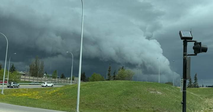
Environment Canada said its meteorologists were tracking a severe thunderstorm capable of producing very strong wind gusts, nickel to ping pong ball size hail and heavy rain.
The severe thunderstorm was located 10 kilometres north of Devon and was moving to the east at 50 km/h.
Earlier in the day, Environment Canada said storms were developing in the foothills, and would move east over western and central Alberta throughout the the afternoon and evening as a cold front moves in.
The thunderstorms may become severe, producing large hail, strong wind gusts and local downpours, the weather agency said.
Story continues below advertisement
Environment Canada said supercell and tornadic development are a concern from around the Airdrie area, north to Drayton Valley, and then east across the QEII.

Get breaking National news
For news impacting Canada and around the world, sign up for breaking news alerts delivered directly to you when they happen.
Severe thunderstorm watches were issued around noon for a swath of the province, from north of Calgary to north of Edmonton, and from the foothills to eastern Alberta.
“The city was put under a severe thunderstorm watch as of 12:54 p.m. and may pick up some of this afternoons activity , though the heaviest storms are still expected outside the city,” said Global Alberta weather specialist Phil Darlington.
More on Canada
More videos
The warning area will likely change as the conditions do, so Albertans are advised to watch for advisories specific to their area.
Any severe thunderstorms that do develop will move to the east or southeast through the evening and overnight hours.
The strong wind gusts can damage trees and buildings and overturn vehicles. Large hail can cause significant damage and injury.
Trending Now

France’s Macron sues U.S. media personality for claiming his wife is a man

Jimmy Kimmel delivers biting response to Trump’s ‘next to go’ threat
Friday is also shaping up to be a concerning day for severe weather over southern Alberta as the cold front presses southwards.
“Even though the current focus is on the storms for Thursday afternoon, there is likely to be activity on Friday too,” Darlington said
Story continues below advertisement
“Conditions for tornado activity return for southern Alberta, and a chance for funnel clouds stretches across a large portion of the north.
“Across both regions winds may also be a lot stronger with gusts possibly reaching close to 100 km/h.”
Warm, humid air is providing plenty of instability.
“Edmonton already started to feel the muggy weather (Thursday) morning and by noon, made our 25 C feel more like 27 degrees with the humidex,” Darlington said.
“We are expecting the humidex to keep the city feeling two to four degrees warmer than it actually is.”
Severe thunderstorm watches are issued when conditions are favourable for the development of thunderstorms capable of producing damaging hail, wind or rain.
© 2025 Global News, a division of Corus Entertainment Inc.