
Breadcrumb Trail Links
Published Mar 07, 2026 • Last updated 4 hours ago • 3 minute read
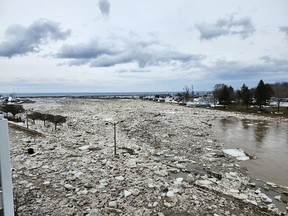
 An ice jam caused the Bighead River to flow over the retaining wall near the harbour in Meaford on Saturday. Photo supplied by Vanessa KnightArticle content
An ice jam caused the Bighead River to spill over a retaining wall in Meaford near where it bends at Bayfield Street and Trowbridge Street East on Saturday afternoon.
Advertisement 2
This advertisement has not loaded yet, but your article continues below.
Article content
The municipality said in a media release that localized flooding occurred along the Bighead River as ice jammed the river’s flow between the Bridge Street Bridge and the Edwin Street Bridge in town.
Article content
Recommended Videos
Article content
Videos posted to social media show backhoe operators scooping massive chunks of ice from the river as water flows into a nearby parking lot. Much of Bayfield Street near the bridge was covered in ice. Another video posted to social media showed a John Deere backhoe using its loader to clear a path through chunks of ice on the roadway. Another image showed two partially submerged cars.
 Chunks of ice cover Bayfield Street in Meaford on Saturday afternoon after an ice jam caused the Bighead River to flow over the retaining wall. Workers used backhoes to clear the ice and restore the river’s flow. Photo supplied by Vanessa Knight
As of Saturday afternoon, the Municipality of Meaford said river flow was restored, and crews were monitoring the area and conducting clean-up efforts. The municipality is also asking residents as of Saturday evening to avoid the river and any remaining ice flow, as conditions remain unpredictable and may shift without warning.
![]()
Sun Times Extra
Thanks for signing up!
Article content
Advertisement 3
This advertisement has not loaded yet, but your article continues below.
Article content
Meanwhile, Bruce County issued a media release Saturday warning motorists that some county roadways are flooding due to heavy rains and the swiftly melting snowpack.
The county said its operations crews are responding to areas with localized flooding affecting road conditions. We are working closely with OPP to address issues as they arise.
Videos posted to social media showed flooding over a roadway in Formosa.
Saugeen Conservation and the Grey Sauble Conservation Authority upgraded their flood outlook statement to a Flood Watch on Saturday.
Overnight, the Saugeen watershed received up to 23 millimetres of rain. Rain is forecast to continue this afternoon, then taper off this evening, with additional amounts of up to 10 millimetres. Temperatures will continue to rise, and are expected to hit a daytime high of 14 C today.
Advertisement 4
This advertisement has not loaded yet, but your article continues below.
Article content
Water levels are expected to continue rising throughout today, with small watercourses likely to reach the top of their banks, resulting in flooding of typical low-lying areas.
Grey Sauble Conservation Authority (GSCA) said that following significant, intense rainfall from midday today, local waterways have become overwhelmed, and the flow response in major rivers has been quicker and higher than expected.
Much of the GSCA watershed received 25-40 millimetres of rain over the last 24 hours, with several periods of heavy rain at times, which led to quick runoff to local streams, the GSCA said in a media release. Water levels along the Bighead River and Beaver River are rising quickly and are expected to exceed normal spring levels, and may reach similar levels to the 2025 snowmelt event.
Advertisement 5
This advertisement has not loaded yet, but your article continues below.
Article content
GSCA said both river systems are expected to peak Saturday night. The Sauble and Sydenham Rivers are also expected to get close to or exceed normal spring levels, but are typically slower to respond and are expected to peak on Sunday. There is the potential for riverine flooding and for bridges to be flooded, restricting access in some areas.
Saugeen Conservation said larger watercourses will be slower to respond and, depending on the timing and amount of rainfall today, may not reach peak water levels until Sunday or Monday.
Warm temperatures are expected to continue until Wednesday. Forecasts are also advising additional rainfall mid-week. Water levels are expected to remain high.
The Saugeen Conservation’s Flood Watch does not require municipalities to take emergency action, though municipal staff are encouraged to continue monitoring low-lying and flood-prone areas. The public is advised to exercise caution near all watercourses. Stream and river flows will remain strong and hazardous, and riverbanks may be unstable.
Advertisement 6
This advertisement has not loaded yet, but your article continues below.
Article content
Residents of both watersheds are asked to secure property around watercourses and remain alert to changing river conditions, and the public should exercise caution near all watercourses.
Saugeen Conservation staff will closely monitor watershed conditions and provide an update if conditions change.
 Fast-flowing water rushes over Inglis Falls on Saturday, March 7, 2026. Greg Cowan/The Sun Times
The Saugeen Conservation Flood Watch will remain in effect until Wednesday, March 11, at 4:30 pm unless updated otherwise.
The GSCA Flood Watch expires Tuesday, March 10, at 4:30 p.m. unless replaced by further updates.
To report flooding in your area, visit our website: saugeenconservation.ca/reportflood.
Municipalities within the Saugeen watershed include: the Municipality of Arran-Elderslie, Municipality of Brockton, Township of Chatsworth, Municipality of Grey Highlands, Town of Hanover, Township of Howick, Municipality of Morris-Turnberry, Municipality of South Bruce, Township of Huron-Kinloss, Municipality of Kincardine, Town of Minto, Township of WellingtonNorth, Town of Saugeen Shores, Township of Southgate, Municipality of West Grey.
Article content
Share this article in your social network