
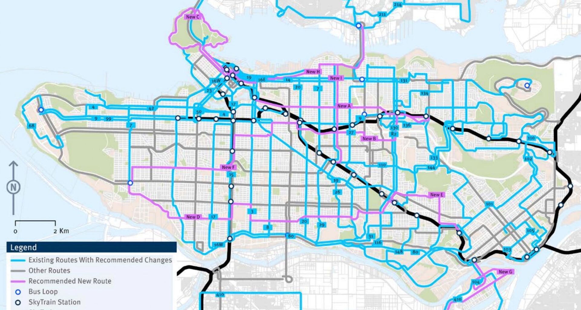
Drastic changes to the bus network are now planned by TransLink for the Burrard Peninsula — the area that encompasses the cities of Vancouver, Burnaby, and New Westminster, as well as the University of British Columbia (UBC) and the University Endowment Lands.
After releasing its draft plan in early 2025 for public consultation, the public transit authority today revealed its finalized Burrard Peninsula Area Transport Plan, which outlines 59 recommended bus route changes to the area over the next 15 years.
This plan to implement changes to existing bus routes and create new routes is highly consistent with last year’s draft plan, including the creation of new limited-stop, express routes, new crosstown routes, new local routes serving corridors without any bus service and experiencing dense urban development, and changes to existing routes — such as adjustments to the path they take, the terminuses, or even the complete elimination of some routes.
However, TransLink emphasizes that many of the planned bus network changes, resulting in a net increase in capacity and service, will require major capital investments, such as expanding bus exchanges, acquiring more buses, and expanding or building new bus depots. In 2024, TransLink noted that it can only increase Metro Vancouver’s overall bus service levels by up to 15 per cent using the existing bus depot facilities, as this is “the maximum operationally feasible” level until bus depot capacity is further expanded. Such facilities are critical not only for storing vehicles but also for maintaining them.
Some of the plan’s bus route changes will need to be funded through future Investment Plans approved by TransLink’s Mayors’ Council, while smaller adjustments could be introduced through the public transit authority’s regular quarterly bus service changes.
Burrard Peninsula Area Transport Plan, final. (TransLink)
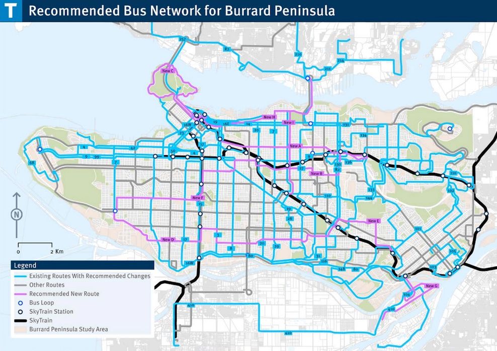
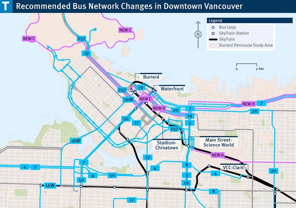
New Stanley Park Drive bus route, and network changes for Broadway Subway
The plan specifically includes the creation of a brand-new additional bus route to Stanley Park. This new local route will traverse the entirety of 8.5-km-long Stanley Park Drive — the park’s perimeter road. The route will begin and end at Waterfront Station.
This additional bus route — complementing the existing No. 19 Stanley Park/Metrotown Station and No. 23 English Bay/Main Street-Science World Station routes — which comprehensively serves the popular park destination, is already funded through TransLink’s 2025 Investment Plan, with the Vancouver Park Board previously indicating the looping route could launch as early as 2027.
Burrard Peninsula Area Transport Plan, final. (TransLink)
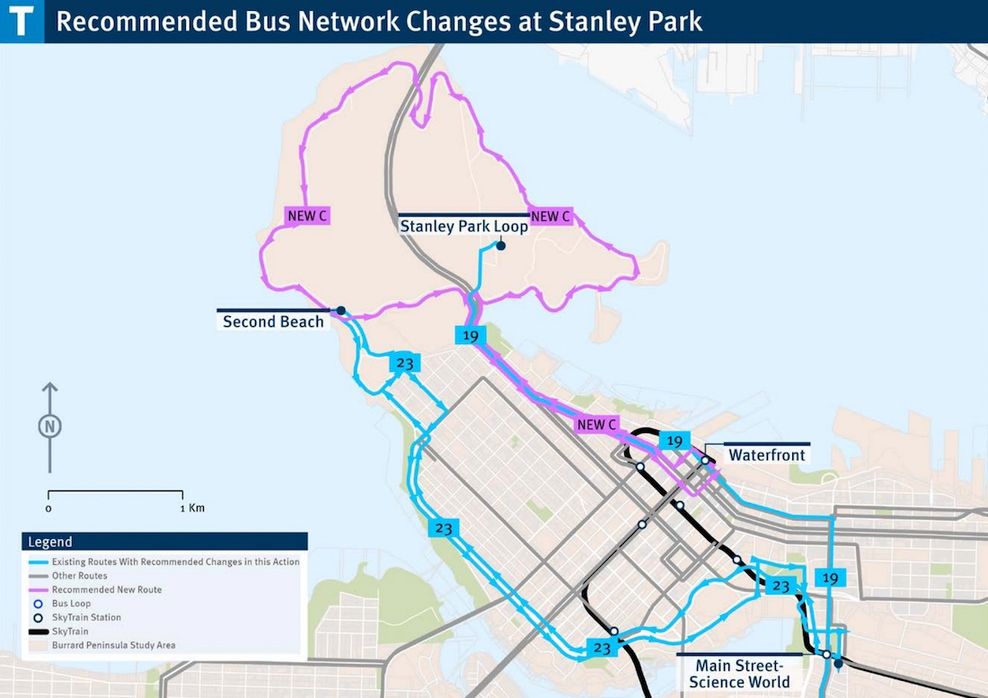
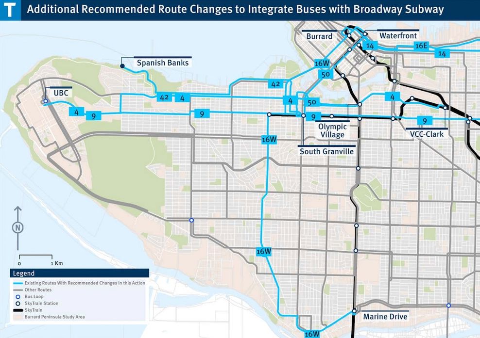
As can be expected, some of the other near-term changes will be a recalibration of the bus network in Fall 2027, when SkyTrain’s Millennium Line Broadway extension opens and results in a truncated 99 B-Line bus route between the new Arbutus Station and UBC. The No. 9 UBC/Alma/Commercial-Broadway local bus route will see increased service to retain frequent bus service along Broadway after the subway opens, with the longer-term possibility of a future eastward route extension reaching the Millennium Line’s Brentwood Town Centre.
Over the last few years, in order to accommodate subway construction along West Broadway, local bus routes such as the No. 14 UBC/Downtown/Hastings and No. 16 29th Avenue/Arbutus have been rerouted to segments of West 4th Avenue and West 12th Avenue, respectively. After the Millennium Line Broadway extension opens, both trolley bus routes will return to their previous West Broadway paths. However, the No. 17 Downtown/Oak local trolley bus route will permanently retain its West 12th Avenue routing segment.
The plan also recommends various additional bus network changes at some point after the Millennium Line Broadway extension’s opening, as measures to further optimize the bus network with the new subway, reduce route duplication, and avoid paths that take buses into traffic-congested areas, especially within the downtown Vancouver peninsula.
A notable additional bus network change at some point after the subway’s 2027 opening is the major rerouting of the No. 4 UBC/Downtown/Powell. Currently a local trolley bus route, it will no longer reach downtown Vancouver; instead, the No. 4 will run east of the Granville Street Bridge, traverse 4th Avenue, 6th Avenue, 2nd Avenue, and Great Northern Way, and terminate at the Millennium Line’s VCC-Clark Station.
The No. 14 will see its route truncated to no longer run between UBC and downtown Vancouver. Instead, its shortened path will run along Hastings Street between downtown Vancouver and Kootenay bus loop.
The existing No. 16 path will be divided into two separate bus routes, with a western route running between Marpole and downtown Vancouver via the Burrard Street Bridge (instead of the Granville Street Bridge) — providing new and improved bus service for the Broadway Plan area and the Senakw rental housing complex — and an eastern route running between downtown Vancouver and northeast Vancouver via Powell, Dundas, Nanaimo, McGill, and Renfrew streets (instead of Hastings Street).
Burrard Peninsula Area Transport Plan, final. (TransLink)
Burrard Peninsula Area Transport Plan, final. (TransLink)
Burrard Peninsula Area Transport Plan, final. (TransLink)
Burrard Peninsula Area Transport Plan, final. (TransLink)
The No. 50 False Creek South/Waterfront Station bus route will see its southern terminus moved to the Millennium Line’s new South Granville Station to enhance its connectivity to the extended SkyTrain network. Similarly, the seasonal No. 42 bus route reaching Spanish Banks will see its path significantly extended eastward to create connectivity to Kitsilano Beach and terminate at South Granville Station.
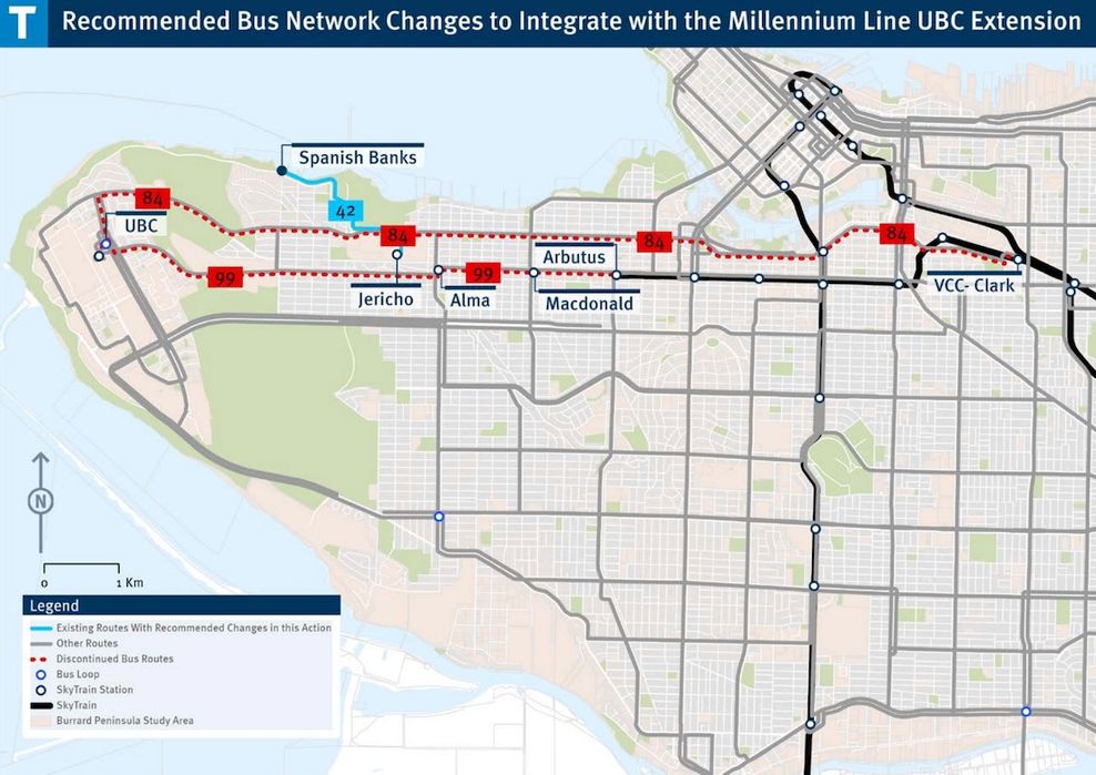
When the Millennium Line is further extended to reach UBC in the 2030s, the No. 42 will see its route substantially shortened, ending at the new Jericho Station. The No. 84 UBC/VCC-Clark Station express bus route could be adjusted into a more limited-stop service or completely discontinued. Moreover, the 99 B-Line will certainly be fully discontinued after SkyTrain is extended to UBC.
New crosstown and limited-stop, express bus routes
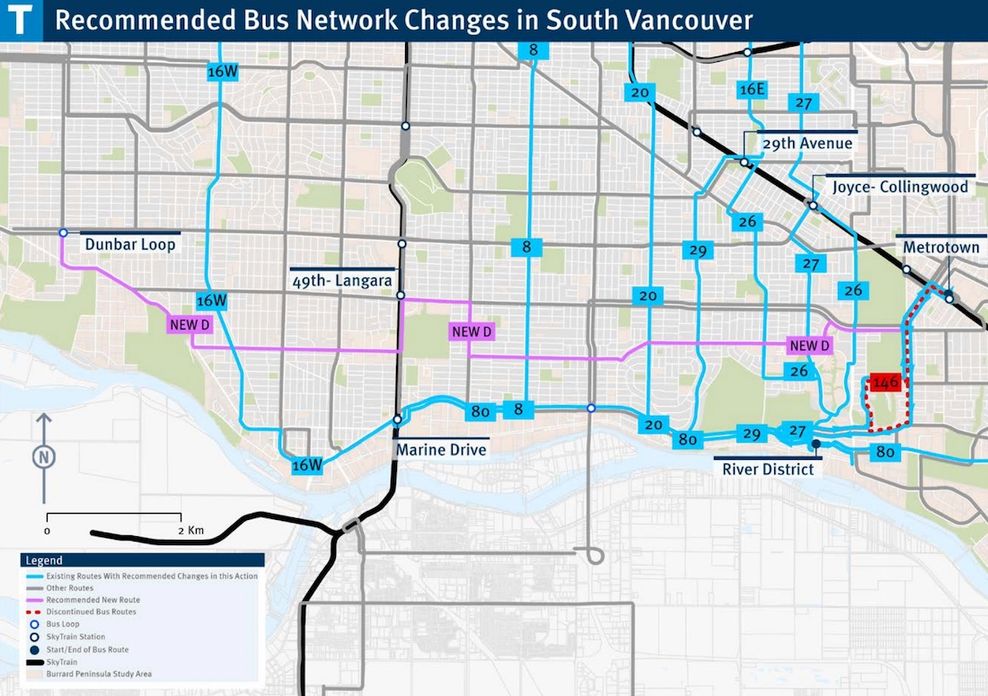
Elsewhere in Vancouver, not directly related to recalibrating the bus network to SkyTrain extensions, the No. 8 Fraser/Waterfront Station route will see its route extended from its current terminus at the intersection of Fraser Street and Southeast Marine Drive to the Canada Line’s Marine Drive Station.
Path extensions and terminus relocations of the No. 20 Downtown/Victoria, No. 27 Kootenay Loop/Joyce-Collingwood Station, and No. 29 Elliott/29th Avenue Station local bus routes will directly serve the rapidly growing high-density residential neighbourhood of River District.
The No. 80 Marine Drive Station/River District express bus route will see its path significantly extended eastward to terminate at the Expo Line’s 22nd Street Station in New Westminster.
A handful of brand-new additional east-west, crosstown bus routes will be introduced under this plan, entailing a new route along 57th Avenue and 54th Avenue between Dunbar bus loop and the Expo Line’s Metrotown Station, a new route along East 1st Avenue between the Expo Line’s Main Street-Science World Station and the Millennium Line’s Holdom Station, a new route along Grandview Highway and Canada Way between Expo/Millennium lines’ Commercial-Broadway Station and Holdom Station, and a new route along West 33rd Avenue and East 16th Avenue between Dunbar bus loop and Commercial-Broadway Station.
Burrard Peninsula Area Transport Plan, final. (TransLink)
Burrard Peninsula Area Transport Plan, final. (TransLink)
Burrard Peninsula Area Transport Plan, final. (TransLink)
Burrard Peninsula Area Transport Plan, final. (TransLink)
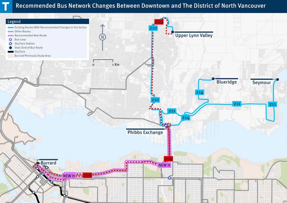
There will be new limited-stop, express bus routes between Phibbs bus exchange in North Vancouver and downtown Vancouver via the Ironworkers Memorial Bridge, McGill Street, and Powell Street, and between Phibbs bus exchange and the Expo Line’s 29th Avenue Station via the bridge and Renfrew Street.
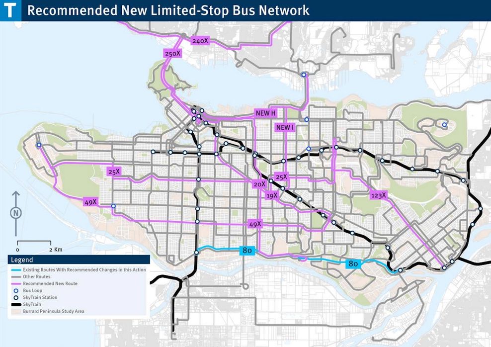
Additionally, seven new limited-stop, express bus routes will be created by mirroring existing local bus routes — entailing the creation of the new No. 19X Metrotown Station/Stanley Park (along Kingsway), No. 20X Victoria/Downtown (reaching River District), No. 25X Brentwood Station/UBC, No. 49X Metrotown/UBC, No. 123X New Westminster Station/Brentwood Station, No. 240X Lynn Valley/Downtown, and No. 250X Horseshoe Bay/Vancouver. Some of the existing bus routes that will be mirrored with express alternatives are among TransLink’s current busiest routes with the highest ridership demand.
Beyond Vancouver, the plan contemplates a number of new bus routes and path adjustments for the network within Burnaby and New Westminster, such as a new route between Edmonds Station and Metrotown Station via Gilley Avenue, Oakland Street, and Grange Street, changes to some existing Burnaby bus routes after the North Shore’s R2 RapidBus is extended south to reach Brentwood Town Centre Station and Metrotown Station, and the eventual elimination of the No. 145 SFU/Production Way-University route after the Burnaby Mountain gondola line opens.
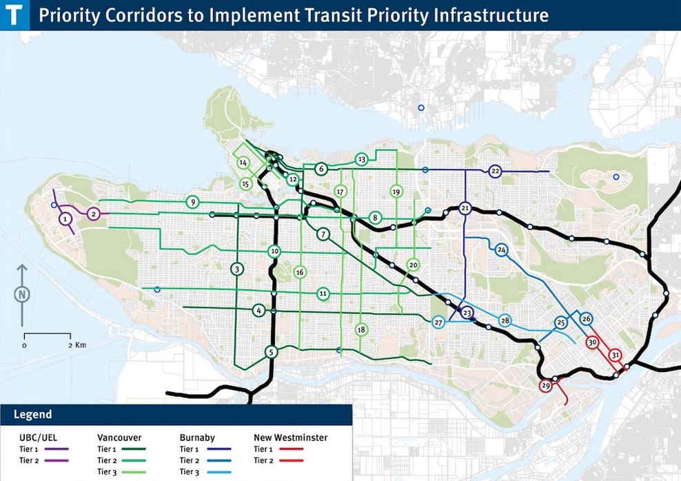
The plan also mentions the potential creation of new bus exchanges for Waterfront Station and the Expo Line’s Stadium-Chinatown Station, along with improving pedestrian and cyclist access to SkyTrain stations and bus exchanges and further enhancing bus speed and reliability through bus priority measures on congested corridors.
Earlier this winter, TransLink launched its initial public consultation process towards creating the new South of Fraser East Area Transport Plan, which will be a similar sub-area bus network improvement plan for Surrey, Langley City, Langley Township, North Delta, and White Rock.