
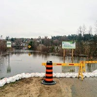
Water levels along the Ottawa River are expected to begin rising over the next few days as the spring freshet gets underway, according to the Ottawa River Regulating Committee. The agency is warning shoreline residents from Mattawa to the Montreal region that rapid increases can trigger minor flooding in low-lying areas.
The Ottawa River Regulating Committee says that levels and flows along the Ottawa River are expected to begin increasing over the next few days due to the onset of the spring freshet in the Ottawa River basin.
It cautions residents along the shores of the Ottawa River from Mattawa down to the Montreal Region that throughout the spring freshet period, which can span several weeks, water levels can rise rapidly at times and cause minor flooding in low-lying areas.
The levels and flows in the Ottawa River are currently close to normal, but are expected to start rising sometime late Friday or into the weekend, depending on locations.
Recent rain and mild temperatures have increased snowmelt, especially in the southern and central parts of the basin. With additional rainfall events forecast over the coming days, spring runoff is expected to continue increasing.
It is too early to predict the magnitude and timing of the freshet peak in the main stem of the Ottawa River. The Regulating Committee will be closely monitoring the effects of precipitation and temperature increases throughout the spring freshet period, as they may cause levels and flows to change rapidly.
A second press release will be published if flood risks increase. Refer to the River Conditions Forecast message for frequent updates on river conditions throughout the freshet.
In mid-March, the amount of water held in the snow cover, or snow water equivalent, was close to average in the central part of the basin, with above-normal amounts in the northwest sub-basins and below-normal amounts in the eastern and southern sub-basins.
Since mid-March, above-normal precipitation has been recorded across the basin, further increasing snowpack volumes, particularly in the north. The central and southern parts of the basin now carry near-average to slightly above-average snow water equivalent, except the southeastern sub-basins, notably the Rideau and South Nation sub-basins, where the snowpack has been largely depleted by melt episodes occurring as early as the first week of March.
Over the past week, a return to near-seasonal temperatures has initiated snowmelt across the Ottawa River basin, with daytime temperatures above 0°C in the southern and central parts of the Ottawa River basin and temperatures at or near freezing overnight. This has resulted in a slow but continuous increase in spring runoff across most of the basin.
Precipitation received across the basin on March 30 and 31 – predominantly rain in the southern and central parts and a mix of rain and snow in the northern part – has further increased runoff. With additional precipitation events forecasted over the coming days, a total of 50 to 70 mm could be received over five days, depending on location.
Spring runoff into the Ottawa River is expected to increase significantly in most areas, causing levels and flows to rise along the main stem of the Ottawa River between Mattawa and the Montreal Region.