

When tectonic plates meet, mountains form, and oceans form where they drift apart.
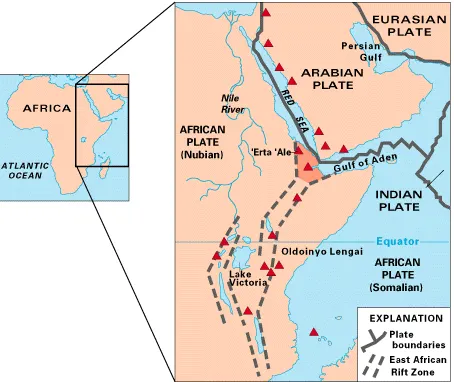
A map of East Africa showing some of the historically active volcanoes (as red triangles) and the Afar Triangle (shaded at the center), which is a so-called triple junction (or triple point) where three plates are pulling away from one another: the Arabian plate and two parts of the African plate—the Nubian and Somali—splitting along the East African Rift Zone. (Source: USGS)
SEE ALSO: Pangolins, the animal kingdom ‘oddballs’, provide important conservation lessons
The East African Rift System is drifting, causing a fracture between its Nubian plate, which contains much of the continent, and the smaller Somali plate that contains most of the eastern coast and Madagascar.
Breakup further along than expected
Researchers used seismic data to determine the thickness of the crust in the region, discovering it is only about 13 kilometres thick in the centre, far less than the 35-kilometre thickness along the edges of the rift.
When a crust’s thickness measures less than 15 kilometres, it enters a phase called “necking,” where the odds of a continental breakup rise sharply.
“We’ve reached that critical threshold” of crustal breakdown, Anne Bécel, a geophysicist at Columbia University’s Lamont-Doherty Earth Observatory and co-author of the study, said in a statement.