
Southern Ontario is about to get its first real taste of summer weather in 2026, and it’s arriving with a potentially stormy side effect.
Temperatures are expected to soar into the upper 20s and even near 30°C in some areas on both Monday and Tuesday as a surge of warm and humid air spreads across the province. While this early-season heatwave will be relatively brief, it’s expected to create a volatile atmosphere capable of producing two consecutive days of severe thunderstorms across parts of Southern Ontario.
From large hail and damaging wind gusts to the possibility of isolated tornadoes, there’s a lot to track over the next 48 hours. Our team will be providing extensive live coverage throughout both severe weather risks on our YouTube channel, with real-time storm tracking, warning updates, radar analysis and live storm chasing coverage as storms develop. If you’re looking for in-depth storm coverage in Ontario, Instant Weather will be the place to be over the next two days.
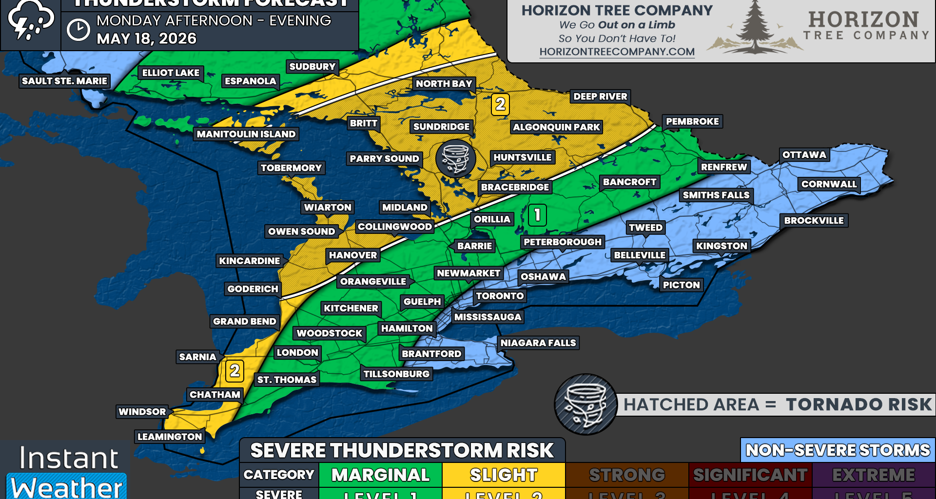
The first round of potentially severe weather is expected to develop during the mid to late afternoon hours on Monday as strong storms over Michigan begin to track into the Lake Huron and Manitoulin Island area around 3-6 PM. These storms are likely to merge into a single line with embedded cells as they cross the Bruce Peninsula and into regions around the northern and eastern shoreline of Georgian Bay. Early in their lifespan, they could present all storm hazards, including damaging wind gusts and hail up to the size of toonies.
As these storms move into Central Ontario, including much of Ontario’s cottage country such as Muskoka, North Bay and Algonquin Park, the environment could become capable of supporting a brief spin-up tornado. There is still some uncertainty regarding the tornado risk as some models suggest the storms may arrive later in the evening, after the most favourable tornado environment begins to weaken.
A secondary cluster of storms may also approach regions further south and west, including Deep Southwestern Ontario and along the eastern Lake Huron shoreline during the late afternoon and early evening hours. At this point, damaging wind gusts appear to be the primary threat in these areas, while the hail and tornado risk looks lower, although it can never be completely ruled out.
As these clusters of storms track northeast, they are expected to gradually weaken by the late evening as the daytime heating fuelling them begins to fade away. Due to this, there remains some uncertainty regarding how far east the severe risk will extend, as it will largely depend on how quickly the storms move before losing access to the strongest instability.
We have gone with a slight (level 2 out of 5) severe thunderstorm risk for locations including Windsor, Leamington, Chatham, Sarnia, Grand Bend, Goderich, Kincardine, Hanover, Owen Sound, Wiarton, Tobermory, Collingwood, Midland, Bracebridge, Huntsville, Parry Sound, Britt, Manitoulin Island, Sudbury, North Bay, Algonquin Park and Deep River. This is the area most likely to experience the strongest storms today, but it’s important to remember that not everyone within the risk zone will necessarily see severe weather.
A marginal (level 1 out of 5) severe thunderstorm risk includes London, St. Thomas, Woodstock, Tillsonburg, Brantford, Kitchener, Guelph, Orangeville, Barrie, Orillia, Bancroft, Pembroke and Renfrew. If severe weather develops in these areas, it will most likely be isolated damaging wind gusts associated with weakening storms during the evening hours.
Non-severe thunderstorms are also possible for the Greater Toronto Area and parts of Eastern Ontario. While widespread severe weather is not expected there at this time, any storms that do develop could still produce frequent lightning, heavy downpours and locally gusty winds.