

A rare weather phenomenon could occur in Ireland tonight, with some areas at risk of thundersnow – a combination of snow and lightning that forms in wintry conditions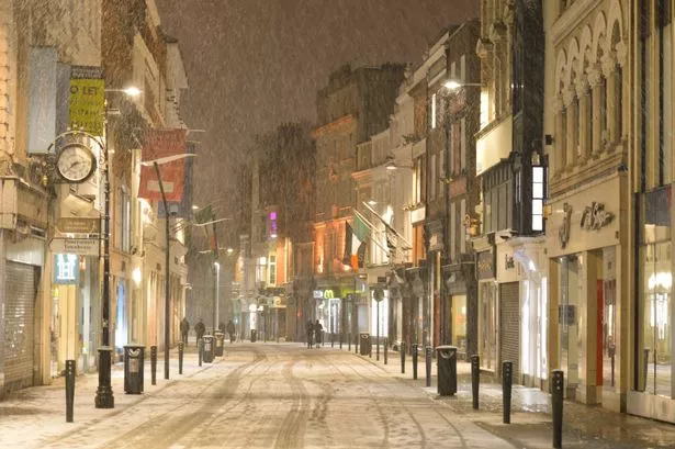 A view of Dublin’s Grafton Street as the ‘Beast from the East’ has hit Ireland with temperatures plunging to -3C tonight and snow showers along with a widespread frost and icy conditions.
On Wednesday, February 28, 2018, in Dublin, Ireland. (Photo by Artur Widak/NurPhoto via Getty Images)
Ireland may experience a rare bout of thundersnow in the coming hours as it braces for an unusual cocktail of wintry weather.
Met Eireann has confirmed the possibility of this peculiar weather event occurring tonight. It stated: “A band of heavy rain will move eastwards across the country later this evening and overnight, followed by squally showers. Some hail and thunder may occur, especially in the northwest where some sleet is possible on high ground.”
This indicates that certain areas in the northwest could witness thundersnow, a unique blend of snow and lightning that occurs when thunderstorms form under chilly conditions. Unlike typical summer thunderstorms, the precipitation in these frosty tempests falls as snow.
The UK’s Met Office clarified: “When thunderstorms form in wintry conditions they can sometimes give rise to heavy downpours of snow which are often called ‘thundersnow’. Thundersnow is unusual only because it can only occur in a few months of the year.
“When thundersnow occurs at night the lightning appears brighter – this is because the light reflects off the snowflakes. Interestingly, the snow contained within the thunderstorm acts to dampen the sound of the thunder. While the thunder from a typical thunderstorm might be heard many miles away, the thunder during a thundersnow event will only be heard if you are within two to three miles of the lightning.”, reports the Irish Mirror.
This unusual occurrence arrives as Met Éireann has indicated that a striking weather reversal is approaching, with turbulent conditions poised to end the present cold snap.
Daytime temperatures throughout the previous week have barely managed to climb into double figures, whilst night-time lows have plunged to as low as -5C in certain areas. Frost, icy surfaces and even snow have become frequent occurrences across much of the nation.
Nevertheless, the national weather service has stated conditions will “turn less cold” this weekend as a period of damp and blustery weather arrives. Ahead of this, Met Éireann has issued three separate weather warnings covering tonight and tomorrow for both rainfall and wind.
The initial alert, a Status Yellow Rain warning for Donegal, Leitrim, Mayo and Sligo, is active for 24 hours from 9pm Saturday until 9pm Sunday. It cautions: “Heavy or thundery rain expected turning showery. Some hail showers also. Spot flooding and difficult travelling conditions are expected.”
A Status Yellow Wind warning has also been issued for Clare, Galway, Leitrim, Mayo and Sligo and is active from 6am until 2pm Sunday. It cautions: “West to northwest winds will be very strong and gusty. Fallen branches, loose debris and difficult travelling conditions are expected.”
A separate Status Yellow Wind warning applies to Wicklow from 10am until 5pm on Sunday. It cautions: “West to northwest winds will be very strong and gusty. Fallen branches, loose debris and difficult travelling conditions are expected.”
The overall forecast for tonight and tomorrow reads: “A mix of cloud, bright spells and scattered showers Saturday with a few prolonged showers in Munster. Cloudier weather with more persistent rain will develop in the south and west during this evening. Highest temperatures of 7C to 11C in light to moderate southwesterly winds.
“Some fog patches forming in the east and north after dark Saturday night. However, a band of heavy rain will move eastwards across the country later this evening and overnight, followed by squally showers. Some hail and thunder may occur, especially in the northwest where some sleet is possible on high ground. Moderate southerly winds will increase fresh and gusty overnight veering westerly, and increasing strong in the west and northwest by morning. Lowest temperatures of 2C to 7C.
“Sunday will bring showers or longer spells of rain, heavy at times with the chance of hail and thunder. There will be some sunny spells too, the best of these in the southwest and south. It’ll be windy in many areas for a time with strong to near gale force west to northwest winds, especially over Connacht, north Munster and Leinster. Highest temperatures of 6C to 10C with winds moderating later.
“Showers will become mostly confined to western parts Sunday night, where some may be heavy and of hail. Under clear spells, it’ll turn chilly with lowest temperatures of 3C to 6C, as northwest winds decreasing moderate in strength.”
Looking forward to the upcoming week, Met Eireann stated: “Drier and brighter for the start of the week before turning more unsettled and milder from around mid-week.”
Join our Dublin Live breaking news service on WhatsApp. Click this link to receive your daily dose of Dublin Live content.
We also treat our community members to special offers, promotions, and adverts from us and our partners. If you don’t like our community, you can check out any time you like. If you’re curious, you can read our Privacy Notice .
For all the latest news from Dublin and surrounding areas visit our homepage.