
A stunning new true-color mosaic of Mars is transforming how scientists—and the public—see the Red Planet. For decades, Mars has been portrayed in exaggerated reds and browns, often adjusted for dramatic effect. Now, a data-driven image, based entirely on visual wavelengths, offers the most authentic view yet of what Mars actually looks like from orbit.
Produced by the European Space Agency (ESA) using the High Resolution Stereo Camera (HRSC) aboard its long-running Mars Express mission, the image is the most detailed and color-accurate global map of Mars to date. It covers the entire surface at a resolution of about 2 kilometers per pixel, built from tens of thousands of observations collected over more than 20 years.
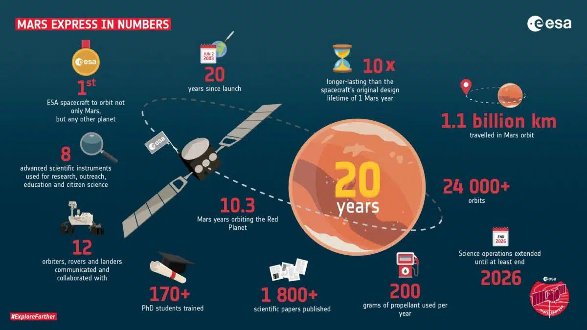 Exactly two decades ago, on 2 June 2003, ESA’s Mars Express orbiter launched and began its journey to the Red Planet – Europe’s first ever mission to Mars. Credit: ESA
The result is not a planet cloaked in red, but a nuanced mosaic—muted grays, yellows, oranges, and pale blues—that captures the mineral diversity of Mars. Regions shaped by ancient volcanic activity, hydrated minerals, and recurring dust storms all reveal themselves in new clarity.
Mars as the Human Eye Might See It
The HRSC camera aboard Mars Express is uniquely suited for building this mosaic. Unlike many space cameras optimized for single-filter imaging, HRSC captures multiple color channels simultaneously and creates high-resolution, 3D stereo views of the terrain. The team used these features to generate a color-calibrated global map, preserving both fine mineral contrasts and realistic shading.
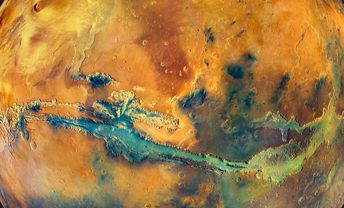
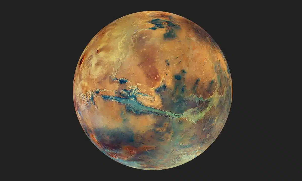 The globe of Mars set against a dark background. The disc of the planet features yellow, orange, blue and green patches, all with an overall muted grey hue, representing the varying composition of the surface. Credit: ESA
This was no simple point-and-shoot operation. The raw data came with multiple challenges: Mars’ shifting dust levels, variable sunlight angles, and atmospheric haze required precision adjustments across thousands of image strips. Each image had to be radiometrically corrected, geometrically aligned, and color-normalized to produce a seamless planetary image.
ESA explains in its official Mars Express instrument page that the HRSC’s configuration of nine CCD line sensors allows for multispectral, stereo, and high-resolution imaging in a single orbital pass. Designed specifically for geological mapping, the instrument has been central to building a continuous visual record of Mars.
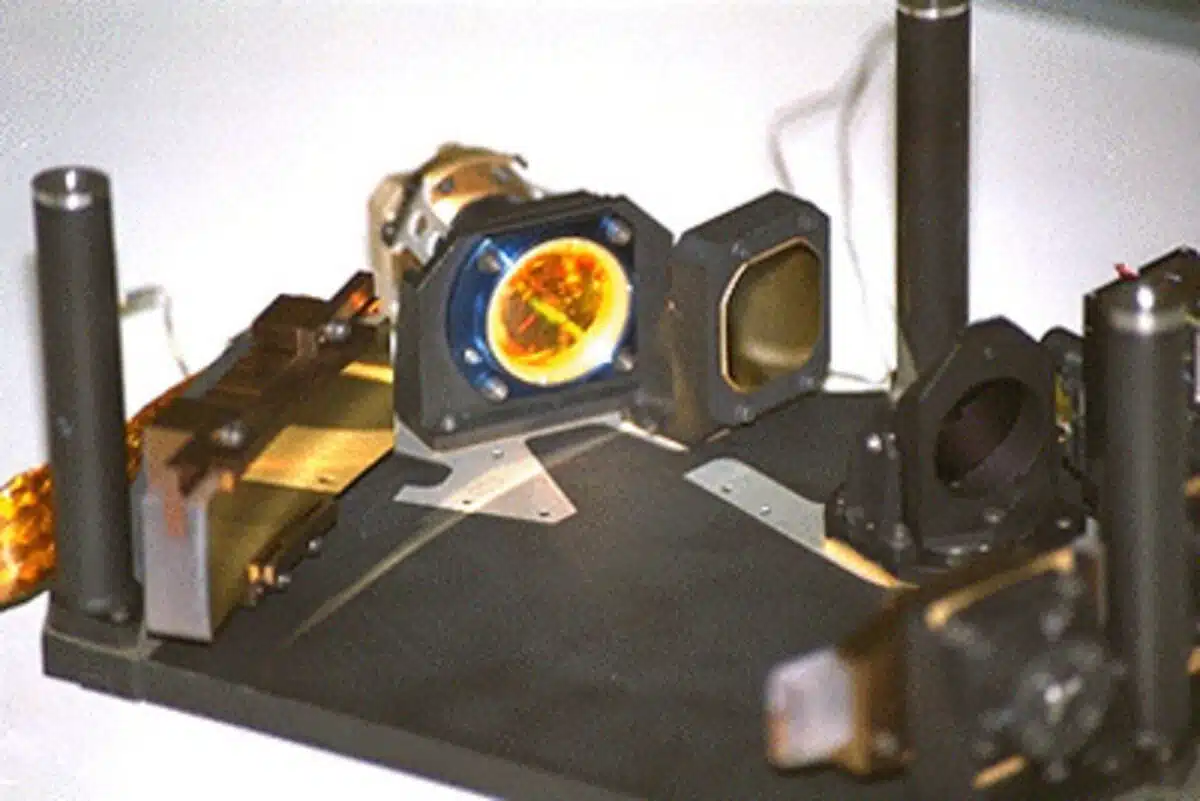
 The High Resolution Stereo Camera (HRSC). Credit: DLR/FU Berlin/ESA 2003
More than a decade of overlapping orbits allowed the spacecraft to repeatedly photograph the same regions under varying conditions. These repeat passes were instrumental in ironing out inconsistencies and producing a consistent color tone across the map.
What the Colors Really Tell Us
Color in this context isn’t just cosmetic—it’s scientific. The true-color mosaic enables researchers to pinpoint basaltic sands, sulfate deposits, iron-rich clays, and other geological features tied to Mars’ ancient volcanic and aqueous activity.
Dark gray and blackish areas, for instance, indicate weathered lava flows and volcanic plains. Lighter zones, often yellow or pale green in the mosaic, signal clay-rich regions formed in the presence of water—clues to a time when the planet may have supported habitable environments.
This compositional clarity is enhanced by cross-referencing with other datasets, including those from instruments like OMEGA, a spectrometer on Mars Express that detects surface minerals in the visible and infrared range.
 OMEGA searches for specific minerals on Mars. Credit: ESA
The image also offers clarity on large-scale features like Valles Marineris, Tharsis Montes, and the Hellas Basin, giving researchers better visual context for interpreting Mars’ tectonic history, erosional processes, and climatic shifts.
Twenty Years of Martian Observation Pay Off
The mosaic is built from image data collected between 2004 and 2022, with key contributions from a series of high-altitude passes between 2015 and 2019. These orbits provided wide coverage that complemented earlier close-up data, filling gaps and unifying color scales across the hemispheres.
Rather than flatten out all shadows for uniform brightness, the team chose to preserve natural light contrasts. This decision helps maintain topographic legibility, allowing viewers to interpret slopes, craters, and ridges based on how light falls across them—similar to how the human eye perceives depth.
ESA’s Mars Express media archive now features this new mosaic prominently. It complements HRSC’s 3D terrain products and adds a valuable layer of spectral context for upcoming missions.
The German Aerospace Center (DLR), which manages the HRSC, continues to provide scientific leadership on Mars imaging. Their institutional hub, DLR.de, includes updates on the mission and related planetary research projects.
Where Planetary Imaging Is Heading Next
What makes this release exceptional is not just its fidelity, but the way it reframes Mars—visually and scientifically. With this true-color baseline, researchers now have a reference that’s both aesthetically accurate and analytically robust.
The mosaic also paves the way for AI-assisted planetary analysis. Machine learning models trained on HRSC data can classify terrain types, identify erosion patterns, and track seasonal surface changes across time. That means more automation, faster insights, and better predictive models for climate and geological behavior on Mars.
Mars Express, originally slated for a two-year mission, is now in its 22nd year of operation. Its longevity—and the quality of data it continues to deliver—demonstrates how legacy missions can still produce breakthroughs long after launch.