
WASHINGTON STATE — “Why do you keep calling this an ‘atmospheric river?’ It’s just Seattle rain!” “It’s supposed to rain in December!” “I remember when this was just called the ‘Pineapple Express’!”
Northwest meteorologists hear all of this and more via emails and responses to online posts about our big Northwest storms. And yes, I remember when unusually warm winter rain WAS simply called ‘the Pineapple Express,’ a term I used a lot in the early 90s when I began forecasting here. However, our knowledge about these storms has come a long way in three decades, and so has our terminology.
ALSO SEE: Second atmospheric river looms as western Washington battles widespread flooding
Terms like ‘bomb cyclones,’ ‘polar vortices,’ and ‘atmospheric rivers’ used to be reserved for the halls of universities, research centers, and science conferences. Bomb cyclones, for example, were first described as ‘sea bombs’ by Norwegian meteorologists about 100 years ago to describe the rapidly developing wind storms that would track into northern Europe in the winter.
The wording and definition were changed and refined a bit as atmospheric scientists at MIT studied these storms in the 1970s. In subsequent papers and presentations, a bomb cyclone was defined “as an area of low pressure that dropped 24 millibars in 24 hours,” and this “bombogenesis” concept was gradually adopted by the weather community.
And there it would stay, quietly remaining within the confines of academia until social media came on the scene. In the 2010s, Environment Canada tweeted about a rapidly intensifying area of low pressure that was wreaking havoc over North America, describing it as a “storm that was undergoing bombogenesis.”
Boom! A few selfies and a trending hashtag later, and #BombCyclone jumped out of the scientific community and into the general lexicon as a social media star.
The term “atmospheric river” has followed a similar path into the mainstream. I first recall hearing it in the early 2000s, when my former colleague, meteorologist Larry Schick, was working for the Army Corps of Engineers. He spoke about the work the Corps did to shore up waterways and protect property from flooding, with the biggest struggle being how to handle “atmospheric rivers.”
ALSO SEE: Snohomish County braces for severe flooding as second storm hits
Larry explained that they were studying how these intense, narrow plumes of water vapor could gather and travel thousands of miles over the oceans, wringing out copious amounts of rain as they slammed into the high peaks of our Pacific Northwest topography.
Of course, the “Pineapple Express” IS an atmospheric river. In fact, it’s the worst kind. While atmospheric rivers *can* travel straight across the Pacific, the subtropically-rooted variety that stretches vertically down to the Hawaiian Islands brings much warmer, wetter air to our region.
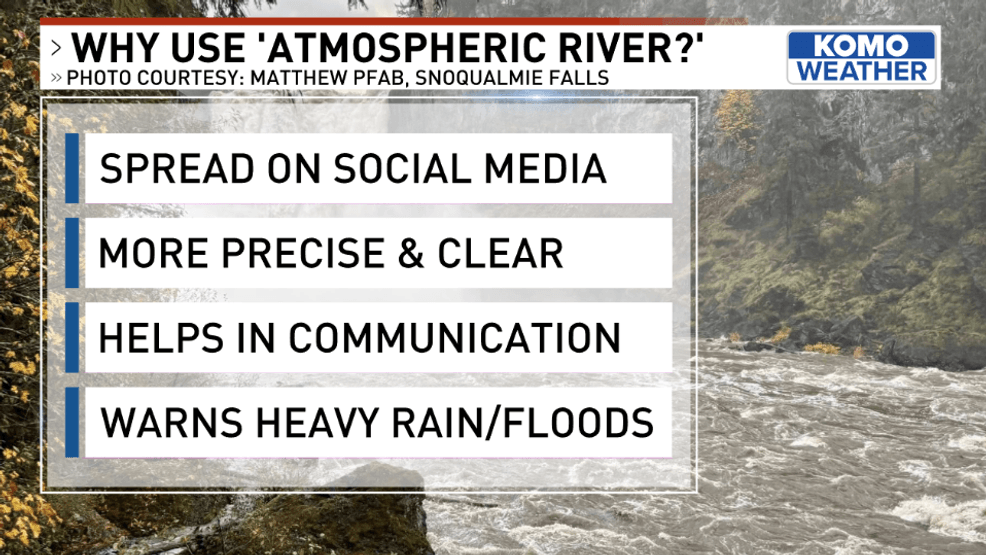
Scientific terms like “atmospheric river” have taken off in recent years due to social media. However, they are helpful in clearly and accurately communicating the strength and intensity of a storm, and the heavy flooding and rain that is often the result of their arrival. Photo courtesy the KOMO Forecast Team.{ }
It brings heavy rain not only to the lowlands, but also to the mountains. Plus, it will also rapidly melt off much of our snowpack as warm air invades and forces the snow level up. As I’ve explained in previous posts, all bourbon is whiskey, but not all whiskey is bourbon. Similarly, all Pineapple Expresses are atmospheric rivers, but not all atmospheric rivers are Pineapple Expresses.
So why use these newer terms to communicate the forecast? The answer is simple: they’re more accurate, they’re more precise, they’re more evocative of what is actually happening.
Can you imagine not using the word “hurricane” to describe a 927 millibar low pushing into the Carolinas in August? While humans had noted that these massive tropical disturbances were bringing on terrible devastation for centuries, the term “hurricane” wasn’t widely adopted until the 1900s, and hurricanes weren’t given names until the 1950s.
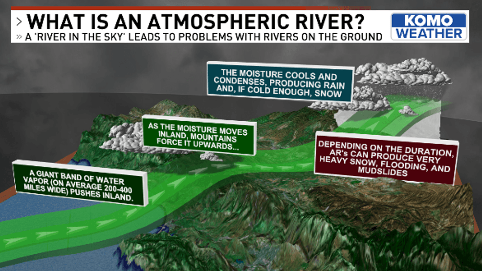
The narrow, focused band of water vapor wrings out copious amounts of precipitation as it rises over our topography in the Pacific Northwest.{ }Photo courtesy the KOMO Forecast Team.
Now, when people hear that a hurricane is coming, they know that it isn’t just a regular storm. Rather, they understand that the weather situation is worth taking seriously–something they should prepare for to protect lives and property.
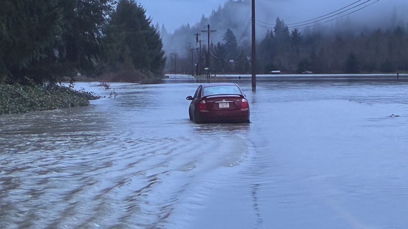
Likewise, an atmospheric river isn’t regular December Seattle rain, and it isn’t a regular winter frontal system, especially if it’s the Pineapple Express variety. The term is reserved for narrow, long plumes of moisture that will wring out heavy precipitation, and they storms often lead to urban and river flooding like we are experiencing now. Meteorologists use this term to let you know that the rain on the way will be anything but garden-variety.
Bottom line: as our weather knowledge grows, so does our weather vocabulary. The need to differentiate the various types of storms is crucial for clear and accurate weather communication.