
Main Points
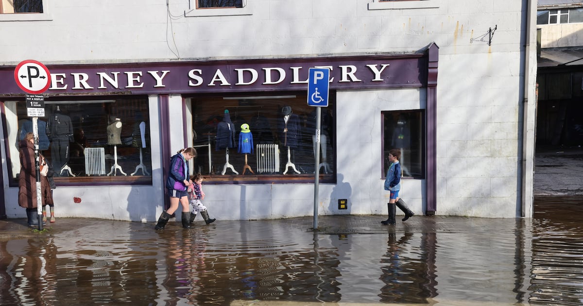
Heavy rainfall due on Friday is expected to hit many of the same areas that were flooded on Tuesday, Met Éireann has said.Co Louth has been added to the yellow rainfall warning which was already in place for Carlow, Kilkenny, Dublin, Wexford, Wicklow and Waterford from midday.The national forecaster said there is a high likelihood that the conditions could lead to localised and river flooding.
Órla Ryan – 14 minutes ago
#TRAIN #ENT❗Due to flooding on the line between Belfast & Dublin, a reduced timetable is in place today, Friday January 30th.
Bus transfers will operate to Newry- please allow extra time for your journey.
ℹ️ Click here for further details 👉 https://t.co/nTtZDuNYJ6
— Enterprise Train (@EnterpriseTrain) January 30, 2026
The Enterprise train between Belfast and Dublin is operating on a reduced timetable due to flooding on the line.
Bus transfers are in place between Newry and Belfast.
Órla Ryan – 26 minutes ago
➡️Rain in Ulster this morning, scattered heavy showers elsewhere☔️
➡️Heavy rain will move into SW around midday & spread across most of Leinster & E Munster this afternoon & evening, isolated thunder possible🌧️
➡️Further localised flooding is possible⚠️
➡️Highs of 7 to 10 C🌡️ pic.twitter.com/8OuCcV6CDF
— Met Éireann (@MetEireann) January 30, 2026
More flooding is expected, particularly in the east and south east, as heavy rain moves across Leinster and east Munster on Friday afternoon and evening.
“Some thunderstorms are possible too,” Met Éireann has said.
“Scattered showers will continue in other areas. With saturated ground conditions and high river levels, further localised flooding is possible.”
Highest temperatures will range from 7 to 10 degrees.
Órla Ryan – 49 minutes ago
Warning for drivers
There will be an increased number of Garda checkpoints on the roads over the bank holiday weekend.
Garda Supt Liam Geraghty has encouraged road users to take extra care and for all drivers to slow down.
“This weekend is going to be very, very challenging, right across the country, even if you’re outside of the counties which have yellow rain warning,” he told Morning Ireland.
“Everywhere around the country at the moment is very, very wet. Our roads are very wet and, because of that, there will be additional muck. There may also be debris from wind and trees and branches on our roads.
“So, the starting point is for everybody to slow down. If you’re driving at a slower speed, you have a better capacity to react to dangers on the road as they happen in front of you.”
 Garda Supt Liam Geraghty has encouraged drivers to slow down this weekend. Photograph: Sam Boal/Collins
Supt Geraghty also advised against driving through roads blocked with water.
“If you’re coming across a road that is blocked with water, don’t take the chance … At very least, you may damage your vehicle with floodwater damage. At the very worst, you may not have to be rescued by the emergency services, who are already quite busy this weekend.”
Supt Geraghty warned people against using their phones while driving, saying this is a big distraction which can cause accidents.
He said gardaí have in the past also come across “men shaving, women applying makeup, doing all sorts of things behind the wheel of the car, besides concentrating on the actual driving”.
More flooding expected
Linda Hughes, a meteorologist with Met Éireann, said more flooding is expected in some areas today.
Speaking to RTÉ Radio’s Morning Ireland, she said: “We’ve had very high accumulations of rainfall in the past couple of weeks. And obviously we’ve seen the severe flooding in some places as well.
“There’s been no break since Storm Chandra and another spell of rain is coming in. So, while rivers did decrease, further rain on top of that now, again, is going to cause some further issues.”
In term of Friday’s weather, Ms Hughes said “another band of rain is expected to move up from the south east, and that will spread across most of Leinster and into eastern parts of Munster as well”.
The seven counties which will be under a status yellow rain warning from midday until midnight – Carlow, Dublin, Kilkenny, Louth, Wexford, Wicklow and Waterford – are expected to be worst impacted.
“Thirty or 40 millimeters in these areas, possibly a little bit higher than that, particularly over higher elevations,” Ms Hughes said.
“In mountainous areas, we could see some accumulations higher than that. This spell of rain will be a quite persistent spell of rain, rather than showers. So, it is going to be really a wet afternoon and evening right across the region.”
Yellow rain warning issued
❗️Timing update⚠️Rain Warning🟡🌧️
➡️Carlow Dublin Kilkenny Louth Wexford Wicklow Waterford
⏳12:00 Fri to 00:00 Sat
‼️Water has limited capacity to soak into the ground, so runoff may increase quickly especially in low lying or poorly drained areas⚠️
ℹ️https://t.co/w5QtJ1UyEP pic.twitter.com/h5UiVU9vVf
— Met Éireann (@MetEireann) January 30, 2026
Met Éireann has issued a status yellow rain warning for seven counties: Carlow, Dublin, Kilkenny, Louth, Wexford, Wicklow and Waterford.
The warning will be in effect from noon on Friday until midnight.
Further heavy rain and showers falling on already saturated ground, combined with high river levels, will lead to localised flooding and difficult travel conditions.
A yellow rain warning for Antrim, Armagh, Down, Fermanagh, Tyrone and Derry has been in effect since midnight. It will remain in place until 6pm on Friday.
Spells of heavy rain will lead to some transport disruption and flooding in places, the UK Met Office said.
As we brace for more rain today and over the weekend, researchers at Maynooth University have given some insights into Storm Chandra.
Climate change made the flooding earlier this week almost three times more likely to occur, analysts have told Caroline O’Doherty, our Climate and Science Correspondent.
The researchers said the high volume of rain that fell in the seven days up to and including Storm Chandra turned the heavy but “not particularly remarkable” rainfall into a “devastating” flood event.
They found the magnitude of the rainfall over the full week was 9 per cent greater than it would have been in the cooler Earth that existed before climate change.
“We would have expected similar seven-day rainfall to happen once in every 150 years,” they said.
Read their full insights here.