
Series of Status Orange and Yellow warnings in placeCoast Guard has asked public to stay away from waterways and exposed coastal areasSome schools close today as flooding may affect transport
Follow the Irish Independent’s liveblog:
Key updates
People rescued from cars as motorists advised not to drive through flooded roads
Met Éireann brings weather warnings forward
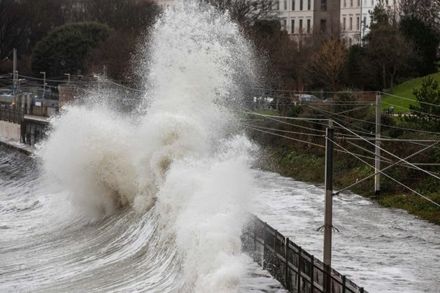
LATEST: More homes and businesses at risk as flood threat to peak this morning Series of Status Orange and Yellow warnings in place Coast Guard has asked public to stay away from waterways and exposed coastal areas Some schools may close today as flooding may affect transport The threat of flooding is set to peak this morning, with road networks expected to bear the brunt of the deluge. However, damage to residential and commercial properties is also likely, emergency services have warned. With Dublin, Louth, Waterford and Wexford under Status Orange rain warnings, people in those counties have been urged to work from home in order to keep the roads clear for emergency vehicles. With Dublin, Louth, Waterford and Wexford under Status Orange rain warnings, people in those counties have been urged to work from home in order to keep the roads clear for emergency vehicles. A total of 80mm of rain is expected to fall in a 36-hour period, meaning some parts of Leinster will have received more than 210mm of rainfall in the space of just 11 days. Gardaí and the Road Safety Authority (RSA) warned that driving conditions would be potentially dangerous in some areas of Munster, Leinster and south Ulster today because of widespread flooding. Motorists have been urged to postpone all non-essential journeys in Orange areas. Water Safety Ireland and the Coast Guard have asked people to avoid waterways and exposed coastal areas. Flooding also hit the rail network with Dart services suspended between Lansdowne Road and Bray, while bus transfers are operating between Enniscorthy and Wexford where the line has been temporarily closed. Dublin, Waterford, Wicklow and Louth are now the focus of major flood fears, with particular concern at the rising level of the River Liffey. The ESB, which warned that water releases may be necessary because of the surging level of the Poulaphouca reservoir, is liaising with the National Emergency Co-ordination Group (NECG) in a bid to minimise downstream flooding in Kildare and Dublin. Councils have said the problem is exacerbated by high spring tides and a lingering storm surge. A total of 13 counties remain under Orange or Yellow rainfall alerts. A number of schools in Leinster closed early yesterday or will postpone opening today amid concerns over the impact of flooding on peak school transport times. NECG chairperson Keith Leonard said prolonged showers in Dublin, Waterford, Wicklow and Louth have fallen on already saturated river valleys. Mr Leonard appealed to people to work from home in flood-threatened areas today if possible to ease traffic volumes and pressure on emergency services. “One of the things we would ask people is that, if they have the discretion to work from home, it would be useful if they could do so. Roads are going to be very heavily disrupted in some areas on Friday,” he said. “I think we are going to see a lot of flooding across roads and, unfortunately, some residential properties and business premises being impacted as well.” Bus and rail services also face being affected. Farm groups are warning that thousands of acres of farmland are now under floodwaters, as the Slaney, Nore, Suir, Barrow, Blackwater and Liffey rivers broke their banks. Emergency flood defence systems including aqua dams, flood gates, high-powered water pumps and sandbags were deployed in the main flood-threatened towns and cities including Waterford, Dungarvan, Passage, Enniscorthy, Wexford, Arklow, Bray, Dublin and parts of Louth. Flood gates will remain shut along the River Dodder. Four counties were placed under Status Orange warnings because of heavy rainfall and the threat of flooding. Waterford will remain under an Orange alert until 9am today Dublin and Wicklow will have an Orange rainfall in place until 3pm today Louth will remain under an Orange warning until 6pm today Nine other counties are covered by Yellow rainfall warnings The yellow warnings will be lifted for Tipperary, Carlow, Kildare, Kilkenny, Laois and Wexford at 9am today The Yellow alert will remain in place for Monaghan, Cavan and Louth until 6pm today Heavy rainfall over Northern Ireland also prompted the UK Met Office to issue Yellow warnings for Antrim, Armagh, Down, Derry and Tyrone. Travel conditions are expected to prove challenging into tomorrow. Met Éireann’s Gerry Murphy said the concern over the rainfall was because of its prolonged nature rather than its intensity. He said greatest concern was focused on Wexford, Wicklow, Dublin, Waterford and Louth where the most concentrated rainfall fell yesterday and overnight. “It is a prolonged spell of persistent rain all the way through Thursday and into Friday. The concern in terms of impact is that because the rainfall is prolonged the totals will mount up,” Mr Murphy said. A view of Salthill and Monkstown Dart Station yesterday, which was completely flooded as high winds and a high tide affected the coastal rail line. Photo: Damien Storan “The concern is over the impact it will have on already saturated ground and swollen river systems.” While Ireland will get a brief respite from the rainfall over the weekend, further rainfall is expected next week as another Atlantic weather front moves toward the country. “There is more rainfall coming next week, but the hope is that it won’t follow the same track over the south-east and east as over recent days,” Mr Murphy said. One Wexford weather station, Johnstown Castle, has recorded the wettest three-month period for almost a century. A total of 652.5mm of rainfall was recorded, the highest figure for 85 years. Rainfall for January was 230pc above normal averages in some parts of the south-east. Dublin recorded its second wettest January since 1948. Ralph Riegel
PICTURES AND VIDEO: Dublin DART lines and Wexford train line hit by severe flooding
Aqua Dam deployed to Wexford as county braces for more flooding
 Weather warnings
Met Éireann has issued changes to Orange and Yellow warnings this morning as flood threat peaks and travel disruption hits
Where: Status Orange – Rain warning for Louth
When: Valid until 12pm
Where: Status Yellow – Rain warning for Cavan, Monaghan, Dublin, Meath
When: Valid until 12pm
Some schools closed and tankers sent to flooded housing estates in Co Louth
Crews from Louth County Council are responding to a number of areas in Dundalk that are flooded following extreme rainfall overnight.
Tankers have been sent to housing estates including Cluan Enda, Bay Estate and Blackwater Court, which have been flooded once again, although the water levels aren’t as high as they were after Storm Chandra.
Cllr Robert Nash, Cathaoirleach of Dundalk Municipal District said the town “seems to have got away relatively unscathed this time” noting that other areas that had been impacted previously were unaffected this time.
“The school in Bay Estate was able to open this morning as there was no flooding at Hazel Wood Drive.”
Council crews had been on standby last night and sandbags had been delivered to residents and businesses in vulnerable areas.
The sea had topped defences at Blackrock during Thursday’s high tide and the street had been closed to traffic again last night.
Meanwhile, primary schools across the Cooley peninsula in north Louth remain closed today as the county remains under an Orange weather alter until 12pm.
Local councillor Antoin Watters said that flooding in the area was not as bad as had been expected although communities were still on edge with another high tide due this afternoon.
“We’re starting from a very bad place as water levels are so high and the land is waterlogged.”
“There were a few places that had problems and Council crews are already out clearing roads and drains in places around Carlingford and Omeath, Anaverna and Ballymakellet.”
Sandbags had been delivered to areas iof Carlingford, including Trinity Close and Thosel Street, Omeath and Bellurgan that have been flooded during previous storms.
The Louth Weather Facebook page reported that Dundalk and the western end of the county had around 25mm yesterday and that the highest totals were at Ravensdale at 65mm, with another 25-30mm is expected today (Friday).
Louth County Council’s Severe Weather Assessment Team (SWAT) met on Friday morning to assess ongoing conditions across the county.
While no major overnight incidents were reported in several areas, crews continue to respond to localised flooding, debris and storm damage.
In Drogheda and South Louth, no major incidents were reported overnight. There is localised flooding on one side of the Marsh Road, though it remains passable. Wellington Quay is expected to flood at high tide at 2.11pm on Friday, with wave heights forecast to reach 4.54 metres.
There were no major reports in the Ardee and Mid Louth area. Minor flooding on Hale Street in Ardee has since been addressed and crews removed a fallen tree on the R169. In a disappointing development, three one-tonne sandbags placed on the N2
Drogheda Road in Ardee to divert running water away from nearby properties were stolen overnight. Washed-up debris was also cleared from the Port Road.
Members of the public are being urged to remain vigilant for debris on roads, avoid floodwater and adhere to all signage in relation to road closures. Residents are also encouraged to monitor Met Éireann weather updates and check the Louth County Council website and social media channels for up-to-date information on road closures, flooding and community alerts.
An Emergency Response Payment is available to support households living in properties directly affected by flooding. To date, one application has been made in Co Louth. An Emergency Humanitarian Flooding Scheme is also open for small businesses, community, voluntary and sporting organisations impacted by flooding.
Margaret Roddy and Katie Finnegan
N11 among flooded Wicklow roads being cleared as officials warn flood threat is not over
A Status Orange weather warning for Wicklow expired early this morning at 9am, but authorities are warning that flooding risks remain as rainfall continues to move through river catchments and coastal conditions stay hazardous.
A small craft warning remains in place for all Wicklow coasts until 3pm today, with strong easterly winds expected to generate waves and swell. While the next high tide is due shortly after 2pm, it is forecast to be lower than Thursday’s tide, which caused widespread coastal flooding.
Read more here:
People rescued from cars as motorists advised not to drive through flooded roads
The National Director for Fire and Emergency Management has said people have been rescued from trapped cars every day this week due to flooding.
Keith Leonard told RTÉ’s Morning Ireland motorists are being advised to slow down, be mindful of cyclists and pedestrians, and to turn back if they come across flooding on the roads.
“If you come across flooded water, turn back, do not drive into it,” he said.
“Unfortunately, every day this week, we’ve had to rescue people from trapped cars and they’re dangerous and it causes a lot of stress for people when that happens.”
Mr Leonard said there has been some good news this morning as last night’s rainfall was not as heavy as anticipated.
“That’s not to say that the conditions won’t be difficult today. Unfortunately, we have the coincidence of very high tides, surface flooding and very high river levels.
“So, we’re hopeful that we might get away today without too much damage to property, but I think you’ll see roads flooded and particularly along those coastal areas, I think you’re going to see more coastal overtopping throughout today and tomorrow.”
Mr Leonard said rainfall over the Dublin and Wicklow Mountains is going to flow down over the next 24 to 48 hours and the full impact of this will not become clear until later today and early tomorrow.
“We’re on full alert really right throughout the weekend. As I say, the rainfall will be much lower over the weekend, thankfully.”
The National Emergency Coordination Group is set to hold a meeting today at midday.
Mr Leonard said humanitarian assistance, restoring public transport, unblocking roads and assessing damage to property will be the main priorities at the meeting.
For anyone planning on travelling over the weekend, the advice is to allow for extra time on your journey.
“Really, it’s just to give yourself extra time,” Mr Leonard said. “Particularly if you’re travelling to the airport, give yourself that extra hour or two to get there in case there’s extreme congestion on the roads.
“And just look at the local authority websites in your area if you’re travelling, they’re a good source, both the social media and the websites from local authorities as to what the local conditions are like.”
Darragh Nolan
Previously hit Rathfarnham and Nutgrove in south Dublin avoid overnight flooding
Areas of Rathfarnham and Nutgrove in south Dublin that were badly hit by flooding last week remained clear this morning after heavy rain overnight.
At Grange Park in Rathfarnham many home owners had protected their properties with sandbags as a precaution after the nearby Whitechurch Stream, which overflowed last week, started to rise again yesterday.
Although the river did continue to rise during the night its level presented no danger to surrounding property this morning.
Similarly, Nutgrove Avenue remained clear this morning where a local stream that runs through Loreto Park had overflowed last week, damaging businesses and threatening homes.
The River Dodder, fed by the Whitechurch Stream and Owendoher River in Rathfarnham, was running higher this morning than it was yesterday but was not at a height where it could cause flooding on local roads. The Lower Dodder Road can be a particular flood risk after heavy rain but remained clear this morning.
Conor Feehan
Travel distruption on Dart and train lines
Dart services are back in operation between Greystones and Howth, Irish Rail spokesperson Jane Cregan has said, but there are no services between Greystones and Wicklow due to flooding.
Ms Cregan told RTÉ’s Morning Ireland flooding between Greystones and Howth has eased and services are in full operation with some delays, but there is still flooding and debris between Greystones and Wicklow.
However, tare no services operating between Howth Junction and Malahide due to a non-weather-related incident, due to a technical problem with a vehicle carrying out maintenance works.
“So, we’re working to get that removed off the line at present, and then between Greystones and Wicklow, we’re not operating because we have debris and flooding on the line.
“So, that’s kind of our situation today. We’re in a better situation than we were yesterday, but we do still have some minor impacts.”
Ms Cregan reminded commuters that Leap cards will be accepted on all other TFI services on affected routes.
She said all services are expected to be back in full operation later today.
“Looking at how bad things were yesterday, how the water did recede, and the Dart line is back operating through that area where there was very bad flooding.
“And as I said, the issue on the north side is not weather related, so we’re hoping that we will have that rectified sooner rather than later.
“And again, we’ll be working with our teams between Greystones and Wicklow to get that service back operating, but we do have a bus transfer operating on that route.”
Darragh Nolan
Update: ➡DARTs operating between Greystones & Clongriffin (both directions).
Belfast & Northern Commuter resuming Malahide & Howth Junction, delays up to +25mins.
DARTs remain suspended between Malahide & Clongriffin. -AD
05.50 Con/Bel +77
06.50 Con/Bel +28
05.30 DD/GCD +53 https://t.co/VRfwfM4pWD
— Iarnród Éireann (@IrishRail) February 6, 2026
Met Éireann brings weather warnings forward
The rain is moving north “quicker than anticipated”, leading to Met Éireann bringing the weather warnings forward.
Met Éireann meteorologist Mark Bowe told RTÉ Radio 1’s Morning Ireland rain has started to ease, though last night was “very, very wet”.
He said the end of the warnings will mark the end of the “persistent and heavy rain” but flooding risks will continue into today.
“We certainly saw some very heavy rain right across parts of the east in the Wicklow Mountains and certainly in parts of the northeast around Louth.
“We saw some good totals right up to around midnight and it started to taper off then over the overnight hours into this morning as well.
So, the totals certainly got up there. We saw some very persistent rain right across the east and northeast in particular, especially across parts of Louth saw the heaviest of the rain last night.”
While the worst of the heavy rain has passed, Mr Bowe said showers will continue to move up across the country from the south for the rest of today.
Darragh Nolan
Some Dart and train services suspended due to floodingDART services are operating between Greystones and Howth this morning, however, Dart, Belfast and Northern Commuter lines are suspended between Malahide and Howth Junction.
Bus transfers are in place between Rosslare/ Gorey to Wicklow and Bray due to debris and flooding on line.
The following services have been cancelled:
05:35 Rosslare/Connolly, bus transfers to Connolly05:45 Gorey/Connolly, bus transfers to Connolly07:10 Rosslare/Connolly will operate to Wicklow, bus transfers from Wicklow to Connolly
LATEST: More homes and businesses at risk as flood threat to peak this morning
Series of Status Orange and Yellow warnings in placeCoast Guard has asked public to stay away from waterways and exposed coastal areasSome schools may close today as flooding may affect transportThe threat of flooding is set to peak this morning, with road networks expected to bear the brunt of the deluge.However, damage to residential and commercial properties is also likely, emergency services have warned. With Dublin, Louth, Waterford and Wexford under Status Orange rain warnings, people in those counties have been urged to work from home in order to keep the roads clear for emergency vehicles.With Dublin, Louth, Waterford and Wexford under Status Orange rain warnings, people in those counties have been urged to work from home in order to keep the roads clear for emergency vehicles.A total of 80mm of rain is expected to fall in a 36-hour period, meaning some parts of Leinster will have received more than 210mm of rainfall in the space of just 11 days.Gardaí and the Road Safety Authority (RSA) warned that driving conditions would be potentially dangerous in some areas of Munster, Leinster and south Ulster today because of widespread flooding.
Motorists have been urged to postpone all non-essential journeys in Orange areas. Water Safety Ireland and the Coast Guard have asked people to avoid waterways and exposed coastal areas.
Flooding also hit the rail network with Dart services suspended between Lansdowne Road and Bray, while bus transfers are operating between Enniscorthy and Wexford where the line has been temporarily closed.Dublin, Waterford, Wicklow and Louth are now the focus of major flood fears, with particular concern at the rising level of the River Liffey.The ESB, which warned that water releases may be necessary because of the surging level of the Poulaphouca reservoir, is liaising with the National Emergency Co-ordination Group (NECG) in a bid to minimise downstream flooding in Kildare and Dublin. Councils have said the problem is exacerbated by high spring tides and a lingering storm surge.A total of 13 counties remain under Orange or Yellow rainfall alerts.A number of schools in Leinster closed early yesterday or will postpone opening today amid concerns over the impact of flooding on peak school transport times.NECG chairperson Keith Leonard said prolonged showers in Dublin, Waterford, Wicklow and Louth have fallen on already saturated river valleys.Mr Leonard appealed to people to work from home in flood-threatened areas today if possible to ease traffic volumes and pressure on emergency services.“One of the things we would ask people is that, if they have the discretion to work from home, it would be useful if they could do so. Roads are going to be very heavily disrupted in some areas on Friday,” he said.“I think we are going to see a lot of flooding across roads and, unfortunately, some residential properties and business premises being impacted as well.”
Bus and rail services also face being affected.
Farm groups are warning that thousands of acres of farmland are now under floodwaters, as the Slaney, Nore, Suir, Barrow, Blackwater and Liffey rivers broke their banks.Emergency flood defence systems including aqua dams, flood gates, high-powered water pumps and sandbags were deployed in the main flood-threatened towns and cities including Waterford, Dungarvan, Passage, Enniscorthy, Wexford, Arklow, Bray, Dublin and parts of Louth. Flood gates will remain shut along the River Dodder.Four counties were placed under Status Orange warnings because of heavy rainfall and the threat of flooding.Waterford will remain under an Orange alert until 9am todayDublin and Wicklow will have an Orange rainfall in place until 3pm todayLouth will remain under an Orange warning until 6pm todayNine other counties are covered by Yellow rainfall warningsThe yellow warnings will be lifted for Tipperary, Carlow, Kildare, Kilkenny, Laois and Wexford at 9am todayThe Yellow alert will remain in place for Monaghan, Cavan and Louth until 6pm todayHeavy rainfall over Northern Ireland also prompted the UK Met Office to issue Yellow warnings for Antrim, Armagh, Down, Derry and Tyrone.Travel conditions are expected to prove challenging into tomorrow.Met Éireann’s Gerry Murphy said the concern over the rainfall was because of its prolonged nature rather than its intensity.He said greatest concern was focused on Wexford, Wicklow, Dublin, Waterford and Louth where the most concentrated rainfall fell yesterday and overnight.“It is a prolonged spell of persistent rain all the way through Thursday and into Friday. The concern in terms of impact is that because the rainfall is prolonged the totals will mount up,” Mr Murphy said.
A view of Salthill and Monkstown Dart Station yesterday, which was completely flooded as high winds and a high tide affected the coastal rail line. Photo: Damien Storan
“The concern is over the impact it will have on already saturated ground and swollen river systems.”While Ireland will get a brief respite from the rainfall over the weekend, further rainfall is expected next week as another Atlantic weather front moves toward the country.“There is more rainfall coming next week, but the hope is that it won’t follow the same track over the south-east and east as over recent days,” Mr Murphy said.One Wexford weather station, Johnstown Castle, has recorded the wettest three-month period for almost a century. A total of 652.5mm of rainfall was recorded, the highest figure for 85 years.Rainfall for January was 230pc above normal averages in some parts of the south-east. Dublin recorded its second wettest January since 1948.
Ralph Riegel
PHOTOS: Flooding on Clontarf Road in Dublin yesterday. Brian Lawless/PA Wire
05/02/26 – Waves crashed against the seawall at Seapoint and flooded the coastal rail line during high winds and a high tide along the Dublin coastline. Photo: Damien Storan.
 Weather warnings:
The current state of play with weather warnings as the rain continues to fall.
Status Orange:
Waterford – until Friday at 9am
Dublin and Wicklow – until Friday at 3pm
Louth – until Friday at 6pm
Status Yellow:
Carlow, Kildare, Kilkenny, Laois, Wexford, Tipperary – until Friday at 9am
Cavan, Monaghan, Meath – until Friday at 6pm
High water levels around Estuary
In case there was any doubt about the shocking weather we’ve had of late, to see this footage sent through by Maxi McCann around the Estuary that shows just what heavy rain on saturated ground combined with high river levels and high tides can do. pic.twitter.com/LUUZi4WKMd
— Fingal County Council (@Fingalcoco) February 5, 2026
Short video shows flooding in Bray as the raging waves breaches the seawall and spill into front gardens of homes
Asked if he was happy with the response by local authorities and the wider government to flooding in communities in recent days, Taoiseach Micheál Martin said there were “a lot of positives, but yes, of course, we can improve in certain areas.”
“Agility is a key issue. So last year on the Western seaboard, we had Storm Eowyn, which is the worst on record in terms of the strength. I convened the meeting immediately after that, and discernible progress can be seen in terms of the evaluation we did in terms of clearing corridors, and in terms of legislation to clarify the role of ESB vis-à-vis access to lands, and in terms of generators being purchased by Uisce Eireann and in terms of identifying community hubs to respond.
“In the context of flood relief. About 56 schemes have been completed in the country. We have about 100 at different stages of development. They are particularly complex.
“In the interim, we need to do more in terms of interim solutions but certainly interim protections, for areas that are low lying, or that are vulnerable to rivers bursting their banks.
“We have to evaluate every time something like this happens, and get better at dealing with these issues as they arise.
“And there are certain areas where we can improve, of that, there’s no doubt.
“And I’ve discussed this with local authorities.
“And on the other hand, it has to acknowledge that some workers have been out in the middle of the night, 5 o’clock in the morning, in Aughrim and elsewhere, doing extraordinary work.
“In Carlow town it was the council workers who protected an entire huge housing estate by very prompt, agile action.
“It was agility personified. I witnessed it myself.
“So there is lot of positives, but yes, of course, we can improve in certain areas.”
Eavan Murray
Some communities could be waiting a decade for flood relief schemes – Taoiseach
Taoiseach Micheál Martin admitted communities experiencing devastating flooding could be waiting over a decade for flood relief schemes to be developed. As the East and South East of the country braces for torrential rainfall with homeowners and business on high alert for flooding in the coming 24 hours, the Taoiseach said there is no quick solution.
Asked specifically by the Irish Independent about serious flooding in South Galway which is now awaiting a decision in relation to its third revised proposal since 2009, he acknowledged “some of them are too slow.”
“They (flood relief schemes) are very long. They are very complex, many of them, but some of them are taking too long to bring to fruition, to bring to conclusion and to make decisions.
“They are not simple. and I don’t mean that as just a cliché.
“Flood relief schemes involve a lot. There’s a lot of directives, environmental directives that have to be adhered to or circumvented or, at least, the challenges of those.
“I saw that in Enniscorthy. But I’ve met with Minister Kevin Moran on this.
“And we’re going to do everything we can to accelerate these flood relief schemes and Get decisions made and submit them.
“As I said, there’s about 100, and at various stages, I’m conscious that one you’ve mentioned hasn’t yet come to finalisation and conclusion.
“But also, I do think we need to look more at the interim solutions as well.
“Because on average, some of these schemes are taking 11 years.
“And the weather is changing fairly rapidly, too.
“Given the complex nature of the engineering involved you are not going to get it all done in a year, I’ll put it that way to you.
“By definition, these are schemes that take some time, but we have to do more of the interim side, and we can do a lot on the interim side.”
“This week has been a very challenging week on the flooding front.
“I appreciate the work and the cooperation between county councils in terms of ensuring that those that are in the front line are getting supports and getting assistance to make sure they can deal with what are very, very elevated levels of rainfall across the country, particularly in the Southeast.”
Mr Martin said the current high water levels haven’t been experienced “for quite some time.”
“It is dramatically higher than what we would have experienced last year, for example.
“And that continues to be the case, and the next few days will be critical and crucial for quite a number of locations.”
Eavan Murray
Wall of sandbags erected along River Slaney in Enniscorthy amid fears of repeat of devastating flooding
Emergency group advises workers in flood-hit counties to work from home if possible on Friday
Workers in counties under weather alerts are being advised to work from home if at all possible tomorrow.
The advice came from the National Emergency Coordination Group, which met again today in response to flooding in the wake of Storm Chandra.
“The NECG is warning that there is a likelihood of flooding today and tomorrow, with orange rain warnings in place for Dublin, Louth, Waterford, and Wicklow, and yellow rain warnings in place for Carlow, Cavan, Kildare, Kilkenny, Laois, Meath, Monaghan, Tipperary, and Wexford. Today’s high spring tides, combined with strong winds and surge, may cause wave overtopping and coastal flooding in exposed areas. High coastal water levels will also impede river discharge, especially at times of high tide,” the NECG said.
“Significant rainfall is expected in areas already affected by flooding over the last period. The NECG has emphasised that, due to river flows, heavy rain in one county can impact on flood-prone areas in another, even where less significant rain has fallen. The risk of flooding will continue into the weekend as upland flood peaks move down through the catchments.”
The group added that councils are monitoring the situation closely and “actively responding to the weather conditions and associated flood risks. Crews are active across their areas, responding to incidents and ensuring precautionary and protective measures are in place”.
Alongside the local authorities, the Irish Red Cross and Civil Defence are ready to support where necessary, the NECG said.
The NECG advised the public to be alert for flooding as “the situation can change very quickly and even small amounts of rain could result in significant impacts in areas where river levels are high and/or where the ground is already saturated”.
“Close monitoring of local weather conditions via www.met.ie and river and coastal level data www.waterlevel.ie is strongly advised.”
The NECG said that where people are threatened by flood waters in their homes or vehicles, they should call 999 / 112 for immediate assistance.
The group added that those in the impacted counties, who have the discretion to work from home tomorrow, Friday, “are urged to do so in order to free up roads for essential services”.
“People are urged to check their local authority website and social media channels for information on road closures, flooding updates, and community alerts. Local authorities are carrying out assessments on roads that were affected by the flooding and, some roads are being kept closed due to damage. Civil Defence remain on high alert and will set up rest centres if needed,” the NECG said.
“Allow for disruption when travelling and plan extra travel time. When driving, reduce speed, expect surface water, debris, and poor visibility. Do not bypass ‘Road Closed’ signs or drive through floodwater; turn back and use another route. Flooding may impact transport services, and the public is advised to check with operators before their journey.”
Waves breach sea wall in Blackrock, Co Louth, as county under Orange warning
High tide at 1.40pm breached the sea defence wall in Blackrock as the high winds and rain battered the Wee County.Flood barriers have been erected along access points to the beach and in the low lying businesses along the Main Street. Louth County Council had issued a weather update as a Status Orange rain warning came into effect across the county.Met Éireann upgraded the warning on Thursday afternoon, with it remaining valid from 12pm on Thursday, February 5, until 6pm on Friday, February 6.The council’s Severe Weather Assessment Team (SWAT) said very heavy rainfall on already saturated ground, combined with high river levels and spring tides, could lead to localised flooding, river flooding, and difficult travel conditions.While river levels have fallen from last week’s peak, many remain close to or above bank-full levels, meaning further rainfall may quickly lead to flooding.The National Emergency Coordination Group (NECG) warned the country is entering another challenging period, noting that rainfall in one county can worsen flooding in neighbouring areas due to river flows.High tide in Blackrock came at 1.40pm on Thursday, with tide levels of approximately 5.42 metres. Main Street in Blackrock was closed for one hour before and after high tide, and motorists were asked not to park on the promenade.In Drogheda, Wellington Quay flood edduring high tide, and the public is being urged to use alternative routes. Motorists were also advised to avoid Haymarket Bridge from the Donore Road, Dublin Road and North Road between 11.30am and 2.30pm on Thursday.Flooding is expected on rural roads near the Rivers Dee, Glyde and Fane, with some road closures planned. Pumping operations are continuing along the Blackwater River in Dundalk to protect nearby residential areas.During the Orange warning, council operations crews will focus on emergency work only, with routine work suspended from midday Thursday.Sandbags are available from council depots across the county, including Ship Street and Wellington Quay in Drogheda, Ardee Civic Office Yard, Dundalk depots, and locations in Baltray and Greenhills. Additional sandbags are being delivered to Carlingford, while protective measures remain in place in Cluan Enda and Bay Estate in Dundalk, and along the N2 Drogheda Road in Ardee.
Words Katie Finnegan
Pictures: Aidan Dullaghan/Newpics
However, damage to residential and commercial properties is also likely, emergency services have warned. With Dublin, Louth, Waterford and Wexford under Status Orange rain warnings, people in those counties have been urged to work from home in order to keep the roads clear for emergency vehicles.
With Dublin, Louth, Waterford and Wexford under Status Orange rain warnings, people in those counties have been urged to work from home in order to keep the roads clear for emergency vehicles.
A total of 80mm of rain is expected to fall in a 36-hour period, meaning some parts of Leinster will have received more than 210mm of rainfall in the space of just 11 days.
Gardaí and the Road Safety Authority (RSA) warned that driving conditions would be potentially dangerous in some areas of Munster, Leinster and south Ulster today because of widespread flooding.
Motorists have been urged to postpone all non-essential journeys in Orange areas. Water Safety Ireland and the Coast Guard have asked people to avoid waterways and exposed coastal areas.
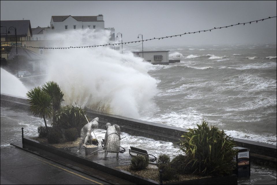
A wave crashes on the shore during the Orange weather alert in Blackrock, Co Louth. Photo: David Conachy
Flooding also hit the rail network with Dart services suspended between Lansdowne Road and Bray, while bus transfers are operating between Enniscorthy and Wexford where the line has been temporarily closed.
Dublin, Waterford, Wicklow and Louth are now the focus of major flood fears, with particular concern at the rising level of the River Liffey.
The ESB, which warned that water releases may be necessary because of the surging level of the Poulaphouca reservoir, is liaising with the National Emergency Co-ordination Group (NECG) in a bid to minimise downstream flooding in Kildare and Dublin. Councils have said the problem is exacerbated by high spring tides and a lingering storm surge.
A total of 12 counties remain under Orange or Yellow rainfall alerts.
A number of schools in Leinster closed early yesterday or will postpone opening today amid concerns over the impact of flooding on peak school transport times.
NECG chairperson Keith Leonard said prolonged showers in Dublin, Waterford, Wicklow and Louth have fallen on already saturated river valleys.
Mr Leonard appealed to people to work from home in flood-threatened areas today if possible to ease traffic volumes and pressure on emergency services.
“One of the things we would ask people is that, if they have the discretion to work from home, it would be useful if they could do so. Roads are going to be very heavily disrupted in some areas on Friday,” he said.
“I think we are going to see a lot of flooding across roads and, unfortunately, some residential properties and business premises being impacted as well.”
Bus and rail services also face being affected.
.jpg)
A man tries to keep his feet dry after flooding on Clontarf Road in Dublin. Photo: PA
Farm groups are warning that thousands of acres of farmland are now under floodwaters, as the Slaney, Nore, Suir, Barrow, Blackwater and Liffey rivers broke their banks.
Emergency flood defence systems including aqua dams, flood gates, high-powered water pumps and sandbags were deployed in the main flood-threatened towns and cities including Waterford, Dungarvan, Passage, Enniscorthy, Wexford, Arklow, Bray, Dublin and parts of Louth.
Four counties were placed under Status Orange warnings because of heavy rainfall and the threat of flooding.
Waterford will remain under an Orange alert until 9am todayDublin and Wicklow will have an Orange rainfall in place until 3pm todayLouth will remain under an Orange warning until 6pm todayNine other counties are covered by Yellow rainfall alertsThe alert will be lifted for Tipperary, Carlow, Kildare, Kilkenny, Laois and Wexford at 9am todayThe Yellow alert will remain in place for Monaghan, Cavan and Louth until 6pm today
Heavy rainfall over Northern Ireland also prompted the UK Met Office to issue Yellow warnings for Antrim, Armagh, Down, Derry and Tyrone.
Travel conditions are expected to prove challenging into tomorrow.
Met Éireann’s Gerry Murphy said the concern over the rainfall was because of its prolonged nature rather than its intensity.
He said greatest concern was focused on Wexford, Wicklow, Dublin, Waterford and Louth where the most concentrated rainfall fell yesterday and overnight.
“It is a prolonged spell of persistent rain all the way through Thursday and into Friday. The concern in terms of impact is that because the rainfall is prolonged the totals will mount up,” Mr Murphy said.
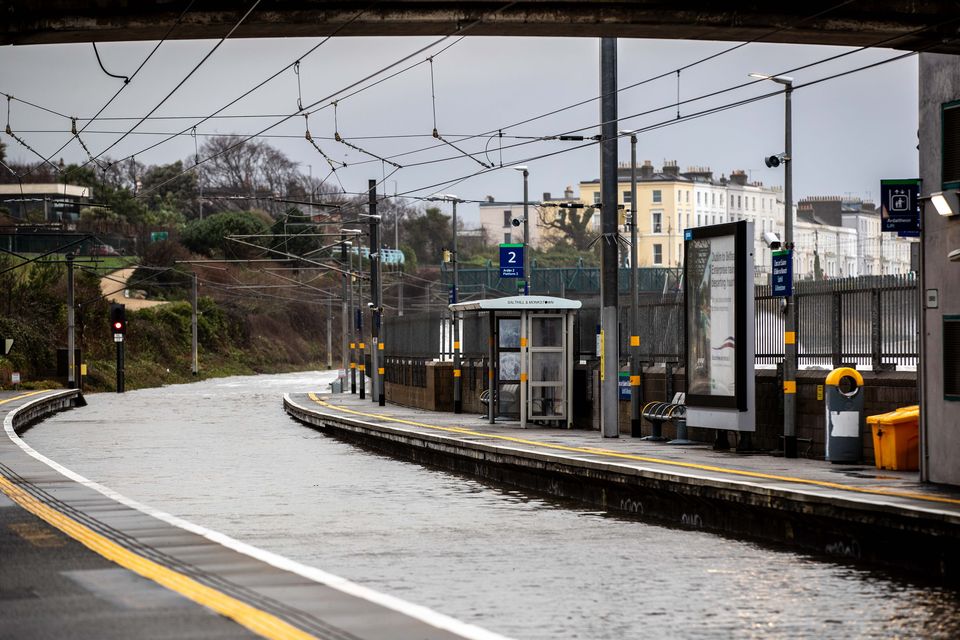
A view of Salthill and Monkstown Dart Station yesterday, which was completely flooded as high winds and a high tide affected the coastal rail line. Photo: Damien Storan
“The concern is over the impact it will have on already saturated ground and swollen river systems.”
While Ireland will get a brief respite from the rainfall over the weekend, further rainfall is expected next week as another Atlantic weather front moves toward the country.
“There is more rainfall coming next week, but the hope is that it won’t follow the same track over the south-east and east as over recent days,” Mr Murphy said.
One Wexford weather station, Johnstown Castle, has recorded the wettest three-month period for almost a century. A total of 652.5mm of rainfall was recorded, the highest figure for 85 years.
Rainfall for January was 230pc above normal averages in some parts of the south-east. Dublin recorded its second wettest January since 1948.