
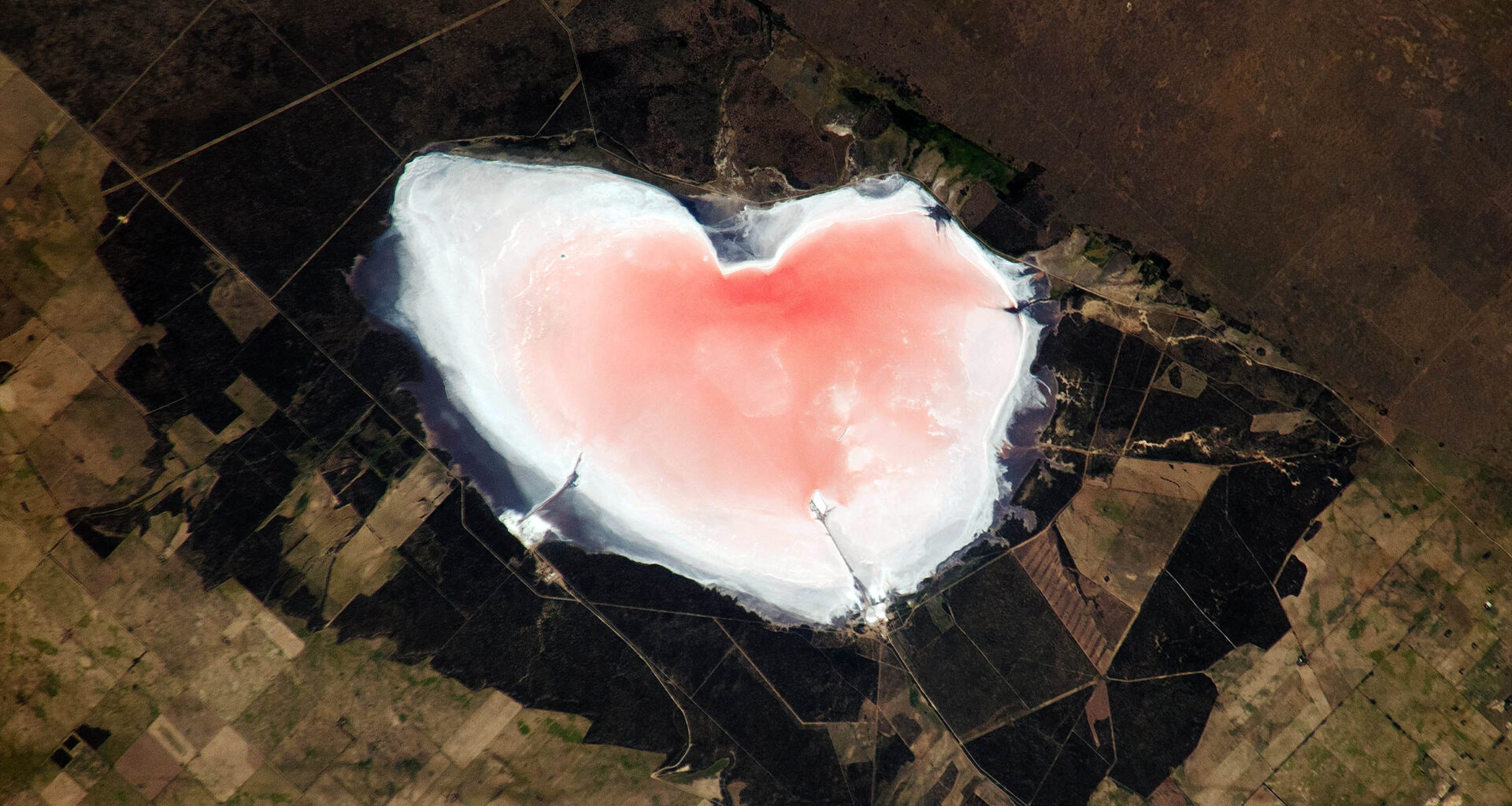
A salt lake in Argentina has emerged from orbit as a nearly perfect pink heart, spanning almost 6.2 miles across at its widest point.
Its color and shape now mark a living system that changes with rainfall and evaporation, turning a striking image into a record of water and salt in motion.
Two hearts, one sky

From space, Salinas Las Barrancas in Argentina’s Buenos Aires province holds that heart-shaped outline in a shallow basin below sea level.
By tracing the lake’s shifting color to its biological source, Maria A. Sierra, Ph.D., at Weill Cornell Medicine mapped the salt-tolerant microbes that give such basins their pink hue.
Her team showed that these organisms thrive under intense sun and rising salinity, allowing the lake’s appearance to intensify or fade as water levels change.
Because that color depends on living communities responding to heat and salt, the heart seen from orbit signals an active process rather than a fixed landmark, setting up the need to understand how climate and chemistry drive what follows.
Ice makes clean lines
Late January 2025 brought enough cold to seal Lake St. Clair, a shallow link between Lake Huron and Lake Erie.
Wind pushed surface water around until it cooled evenly, and thin ice spread when the lake finally lost heat.
Shoreline wetlands and a river delta at the north end helped lock pieces together, keeping gaps from reopening quickly.
Once lake ice formed, it slowed evaporation and cut wave action, changing how the lake traded heat with air.
Satellites watch the ice
Day by day, NOAA’s Great Lakes Environmental Research Laboratory, GLERL, turned satellite views into ice-cover maps for Lake St. Clair.
Cloud-free patches fed GLERL’s process, so the maps updated even when storms hid parts of the water.
Historical records inside GLERL’s archive stretch back to 1973, giving scientists decades of winters to compare under the same system.
Those side-by-side records guide shipping routes and ice fishing plans, while also revealing how quickly a colder season can give way to milder conditions.
Salt flats hold water
In Argentina’s Buenos Aires province, Salinas Las Barrancas lay about 33 miles west of Bahia Blanca, a major coastal port.
Rain briefly fills the basin, which sits below sea level, and intense sun then concentrates salt as water evaporates.
At its widest, the lakebed stretches nearly 6.2 miles across, so a small change in depth redraws the shoreline fast.
Local crews scrape and haul up to 330,000 tons of salt twice a year, working between rainy stretches.
Microbes color the brine
Pink water often forms in very salty basins, and that extra salt blocks most life from taking hold.
Under harsh sun, Dunaliella salina built up carotenoids, orange-red pigments made by plants and microbes, inside its cells.
Other salt-loving microbes add their own pigments, so the brine can turn deeper pink as evaporation pushes saltiness higher.
Because the color depends on living cells, a sudden flood can fade the lake quickly even if the heart outline stays.
Genes explain the pink
To test whether pink lakes share a common cause, Sierra’s group studied Lake Hillier, another bright salt lake in Australia.
Using metagenomics, reading DNA from a community at once, Sierra’s group produced an analysis of pigment makers in water and shore samples.
“Our findings provide the first metagenomic study to decipher the source of the pink color of Australia’s Lake Hillier,” wrote Sierra.
Hillier work cannot pin each shade on one species, yet it narrowed the search to a few chemical steps that make pigments.
Cameras read lake color
An astronaut on the International Space Station snapped the pink heart, and NASA kept the raw frames public.
Different wavelengths bounce back from minerals and pigments, so analysts can map where brine, salt crust, or open water dominates.
When Salinas Las Barrancas turned pale or bright, those color patterns hinted at changing saltiness long before trucks rolled in.
Clouds, smoke, and sun angle can still fool a sensor, so field checks remain the way to confirm what color means.
Wildlife rides the pigments
Even with salt crystals underfoot, green plants ring parts of the flats, because some species tolerate briny soil.
Salt-tolerant plants anchor insects and seeds, and birds follow the food, including Chilean flamingos that filter tiny crustaceans from shallow water.
When microbial populations expand or shrink, the pigments they produce move through the food web and influence the coloration of animals that consume them.
Beyond the narrow shoreline, the saltpan remains largely bare, so most wildlife depends on short wet periods to find enough food.
How hearts take shape
Heart outlines rarely come from one neat process, and they usually form when water meets barriers on both sides.
On a salt flat, ridges and mined channels steer water into two rounded lobes, while evaporation sharpens the edges.
Across Lake St. Clair, ice traced the shoreline it already had, and smooth white cover made the shape stand out.
A small change in wind, water level, or sunlight could erase the heart the next day, leaving only regular geography.
Seen from space, pink brine and white ice looked playful, yet both scenes carried hard information about water moving through extremes.
Future images will help managers, miners, and ecologists spot trouble earlier, but the meaning still depends on boots on ground.
—–
Like what you read? Subscribe to our newsletter for engaging articles, exclusive content, and the latest updates.
Check us out on EarthSnap, a free app brought to you by Eric Ralls and Earth.com.
—–