
Irish weather expert, Alan O’Reilly, of Carlow Weather on X, told his 156,000 followers to expect cooler conditions next week
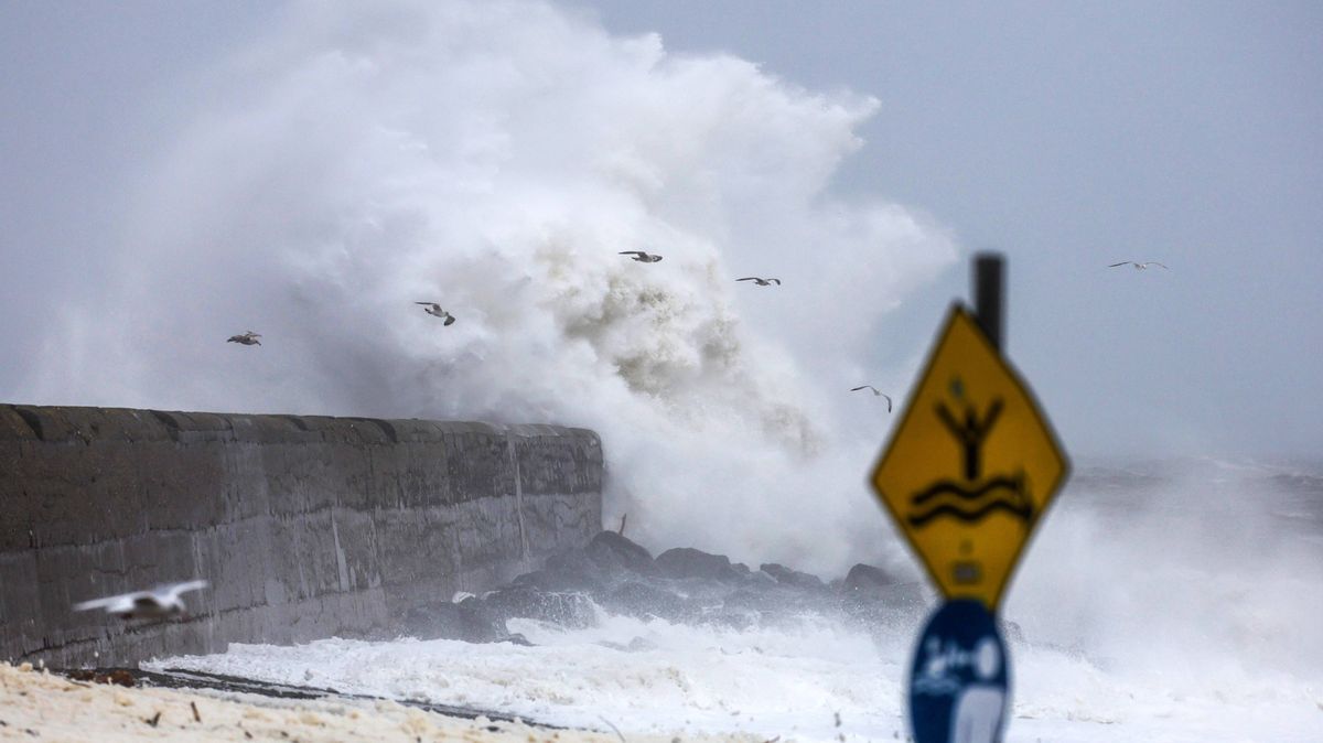
There are concerns parts of Ireland could see gale-force winds next week. (stock image)(Image: Colin Keegan, Collins, Dublin)
As Ireland prepares for hazy sunshine for the next couple of days Met Eireann has sounded the alarm that hail, thunder and potential gale-force winds could be on the horizon next week.
Mist and fog is set to clear quickly on Saturday morning but there will be a chance that some coastal fog may drift onto some coastal parts from time to time.
However, it will be another dry day for most, with spells of sunshine, hazy at times. It will be cloudier on coastal areas of the northwest but dry apart from the chance of a few spots of drizzle. Highest temperatures are expected to be between 11°C and 17°C.
Met Eireann expects that we will start to notice a change in the weather from Sunday onward. People should expect more showers and the temperature is likely to drop to 0°C on Sunday night.
Monday will see a positive start with some hazy sunshine again but this will soon change as more showers and drizzle sets in. Tuesday is when the weather will drastically change, according to Met Eireann who is forecasting “widespread showers following, some of hail, with the chance of the off rumble of thunder”.
Meanwhile, Irish weather expert, Alan O’Reilly, of Carlow Weather on X, told his 156,000 followers to expect cooler conditions next week.
“Good sunny spells again Friday but a little cloud in parts and up to 17c.
“Saturday will see good sunny spells but cloud increasing Saturday night with some patchy drizzle Sunday.
“Turning cooler early next week with sunny spells and showers but rainfall amounts look low at present,” he said.
Met Eireann National Outlook:
Overview: A little rain and drizzle on Sunday as a weak weather front sinks southeastwards, but overall plenty of dry weather for the rest of the weekend and the start of next week. It’ll turn more unsettled and mixed though from Monday night and for the rest of the week with some rain and showers on the way. Colder too, with some of the showers turning wintry through midweek and it’ll be windy at times.
Saturday night: Dry for a time with clear spells and with some patches of mist and fog forming, mainly further south. Cloud will increase from the northwest overnight with a little light rain and drizzle starting to move south-eastwards. Lowest temperatures of 1 to 8 degrees, coldest across the south and southeast, with just light variable breezes initially, becoming mostly light to moderate southwesterly and a little fresher in northwestern coastal parts.
Sunday: Generally cloudy for a time with a little rain and drizzle moving southeastwards. However, a clearance to mostly dry weather with some bright or sunny spells will extend from the northwest to most parts through the morning and afternoon. Highest temperatures of 10 to 14 degrees in light to moderate southwesterly winds, veering northwesterly.
Sunday night: Sunday night will be dry with a mix of cloud and clear spells. Lowest temperatures of 0 to 5 degrees, with a touch of frost possible in places, with just light variable breezes.
Monday: Monday will hold mostly dry with some hazy spells of sunshine, though it’ll become increasingly cloudy with some light rain and drizzle moving into northwestern parts later. Highest temperatures of 10 to 13 degrees with southwest winds increasing mostly moderate, fresher later in western and northwestern coastal parts.
Monday night: A breezy and cloudy night with outbreaks of rain moving south-eastwards to most parts. Lowest temperatures of 6 to 9 degrees in moderate to fresh and gusty southwest winds, stronger in western and northwestern coastal parts.
Tuesday: Cloudy for a time with further outbreaks of rain, heavy at times. The rain will gradually clear southeastwards through the day, with sunny spells and fairly widespread showers following, some of hail, with the chance of the off rumble of thunder. A blustery day with highest temperatures of 9 to 12 degrees in fresh and gusty southwesterly winds veering westerly, strong to near gale force and gusty in western coastal parts.
Tuesday night: Continuing rather windy and showery, some of the showers turning wintry and with a chance of thunder. Lowest temperatures of 0 to 4 degrees in fresh and gusty westerly winds, strong to near gale force in western coastal parts.
Wednesday: A windy and showery day and some of the showers will be heavy, with a chance of thunder. Some will be wintry too especially through the morning and again later. There’ll be some sunny spells also. Highest temperatures of just 5 to 9 degrees, but feeling colder with the added wind chill from fresh to strong and gusty northwest winds, reaching near gale to gale force in western and northern coastal parts.
Thursday: Some frost and ice in parts to begin on Thursday. There’ll still be scattered showers around, some wintry, but overall a good deal of dry weather with sunny spells. Breezy for a time, but the moderate to fresh northwest winds will gradually ease. Highest temperatures of just 5 to 8 degrees.
Further outlook: It looks like the weather will be mixed and changeable over the following few days, with some rain and drizzle from time to time as weather fronts break through, but some dry and sunnier spells too with high pressure moving close by. It’s likely to continue on the cool side with some frost.
Want to see more of the stories you love from the Irish Mirror? Making us your preferred source on Google means you’ll get more of our exclusives, top stories and must-read content straight away. To add Irish Mirror as a preferred source, simply click here.