
Fears are growing that hopes of pleasant Easter weather have disappeared as experts warn of storm risk bringing strong winds and rain to Ireland over the holiday weekend
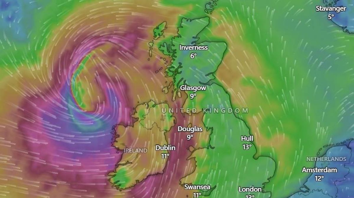
A storm is brewing off the west coast of Ireland and could strike the country in the early hours of Easter Sunday(Image: Windy.com)
Irish weather experts have warned that the risk of a storm over Easter weekend is ‘not an April fools’.
Fears are growing that any hopes of pleasant Easter weather have all but disappeared, with concerns that unsettled weather could spell disappointment for thousands of people planning to spend part of their Easter holiday outdoors. Met Eireann attributes the gloomy forecast to what it describes as a “mobile Atlantic regime”.
This meteorological phenomenon occurs when a powerful, active jet stream drives a quick succession of low-pressure systems from the Atlantic Ocean towards Ireland. Should this materialise, it would bring extended spells of rain and wind to parts of the country throughout Easter weekend, reports the Irish Mirror.
Precisely where it will move across Ireland and its severity both remain uncertain, but forecasters are in agreement – the outlook isn’t promising. Weather expert Alan O’Reilly from Carlow Weather told his audience of over 156,000 followers that the storm threat had “increased”.
“Risk of storm bringing strong winds Saturday has increased on the models but still a lot of uncertainty on the exact track and intensity,” Alan said. “Stay tuned for updates. Rain will move into Northwest this morning, moving Southeast but breaking up followed by cooler air.”
Alan also warned his followers that there was “no sign” of mild weather, and that households should be ready to keep their heating on – despite the substantial increase in energy costs. “There’s no sign of any genuine warm air arriving anytime soon. Heating bills will keep climbing and there’s no indication of any reduction in heating oil prices,” he said.
Weather Alerts Ireland agreed with Alan’s sentiments, saying: “NOT APRIL FOOLS – storm risk for Saturday! An awkward day to write this but this is not April Fools, I promise, unless the charts are fooling me.
“The morning models are forecasting a large storm (I did post the other day of a risk of storms) for Saturday into Sunday! Most of the models are now forecasting this storm which is forecast to impact Ireland.
“Now this is still a little way off yet so time to change but the ECMWF, GFS, ICON and ARPEGE models are forecasting this storm! Watch this space as a named storm is likely if these charts hold.”
According to the 2025/26 storm season list, the next weather system to receive a name from the Met Office, Met Éireann, and KNMI is Storm Dave.
Forecasters have predicted a mild beginning to the new month, with Wednesday due to be bright and mild during the day with some scattered showers and temperatures of 14 degrees. However a cold front will move in tonight, with a huge temperature drop to as low as -1.
Weather Alerts Ireland also forecast that the temperatures will be low for Thursday, which is “bad news” for the energy bill. A post to their social media reads: “Unfortunately colder air is forecast to push over Ireland on Thursday and again over the weekend.”
Meanwhile, Met Eireann’s forecast for the coming days is as follows:
Wednesday: Cloudy conditions with patchy drizzle and mist will give way to rain spreading southeastward through the day. Brighter spells and scattered showers will follow from the northwest during the afternoon. High temperatures reach 14 degrees but will turn cooler as rain clears. Tonight remains mostly dry and clear with frost and ice forming as temperatures drop to -1 degree.
Thursday: A cold and cloudy morning leads to rain moving into the west and spreading across the country by the afternoon. The best of the early brightness will be in the east and southeast. Highs range from 7 to 10 degrees. Rain, drizzle, and mist will persist overnight with lows staying between 5 and 9 degrees.
Friday: Expect a windy and damp day with fresh to strong southwesterly winds and the potential for coastal overtopping. Rain and showers will occur throughout the day with highs reaching 14 degrees. Cloud and further outbreaks of rain will extend from the southwest overnight as temperatures fall to 1 degree in the north.
Saturday: This will be a wet and windy day as strong, gusty southerly winds accompany periods of heavy rain. Temperatures will peak between 10 and 14 degrees.
Sunday: The weather turns cooler and breezy with a mix of sunny spells and showers, some of which may be heavy. High temperatures will reach 11 degrees under moderate to fresh southwesterly winds.
Monday: Uncertainty remains in the long-range outlook, though current indications suggest another spell of wet and windy weather is likely to affect the country.
Want to see more of the stories you love from Dublin Live? Making us your preferred source on Google means you’ll get more of our exclusives, top stories and must-read content straight away. To add Dublin Live as a preferred source, simply click here.
Join our Dublin Live breaking news service on WhatsApp. Click this link to receive your daily dose of Dublin Live content. We also treat our community members to special offers, promotions, and adverts from us and our partners. If you don’t like our community, you can check out any time you like. If you’re curious, you can read our Privacy Notice.
For all the latest news from Dublin and surrounding areas visit our homepage.