
Fears are growing over another named storm hitting Ireland just days after Storm Dave
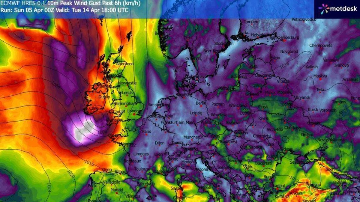
Weather models indicate another stormy weather system is heading for Ireland(Image: WXCharts)
Concerns are already mounting about another named storm potentially striking Ireland, just days after Storm Dave hit the country.
The nation’s fourth named storm of the season delivered winds reaching 100km/h on Saturday, causing travel disruption and power outages. Early indications suggest another possible storm threat looming for the week after next..
Met Eireann says low pressure and high pressure systems are likely to clash during the week of April 13 to 19. Low pressure systems bringing rain and strong winds will push in from the Atlantic, while high pressure edging in from the east could allow conditions to become more settled at times.
The forecaster stated: “This week will bring mixed conditions and while low pressure in the Atlantic will send in spells of rain and possibly windy weather, high pressure to the east and northeast will move closer and start to play a more dominant role over our weather, mostly likely for the second half of the week. It’s still likely to be wetter than average, but it’s likely to be milder than average.”, reports the Irish Mirror.
This comes as long range weather models, which remain highly changeable, pointing towards another storm system potentially reaching Ireland around Wednesday, April 15.
Should that system intensify as certain forecasts predict, it would receive the name Storm Eddie, marking the fifth named storm of the season. Storms generally receive names when orange or red warnings are issued for medium to high impact weather conditions, including strong winds, heavy rainfall or snowfall. This season has already brought Storm Amy, Storm Bram, Storm Chandra and, most recently, Storm Dave to Ireland.
Meanwhile, a varied Easter bank holiday Monday lies ahead for the country. Met Éireann stated: “Monday will be mainly dry with a good deal of cloud. There’ll be a few sunny breaks, mainly in the east. Some patchy light rain and drizzle will occur, mainly in Atlantic coastal counties. Highest temperatures of 10C to 14C with moderate to fresh south to southeast winds, strong at times near the south-west coast.
“Dry and mostly clear over the eastern half of the country through Monday night. Variable cloud further west with some showery outbreaks of rain moving in towards morning. Lowest temperatures of 6C to 9C in moderate, occasionally fresh southeast winds.”
For the remainder of next week, Met Éireann indicated that periods of wet and blustery conditions are expected at times, with the possibility of thundery downpours, though drier and brighter spells will also feature.
Want to see more of the stories you love from Dublin Live? Making us your preferred source on Google means you’ll get more of our exclusives, top stories and must-read content straight away. To add Dublin Live as a preferred source, simply click here.
Join our Dublin Live breaking news service on WhatsApp. Click this link to receive your daily dose of Dublin Live content.
We also treat our community members to special offers, promotions, and adverts from us and our partners. If you don’t like our community, you can check out any time you like. If you’re curious, you can read our Privacy Notice.