
Weather satellites have now yielded hourly maps of ocean currents, revealing motion in the Gulf Stream that older systems blur or miss.
That new view changes what scientists can watch in near real time, especially small currents that stir the ocean and move material quickly.
Clues in heat

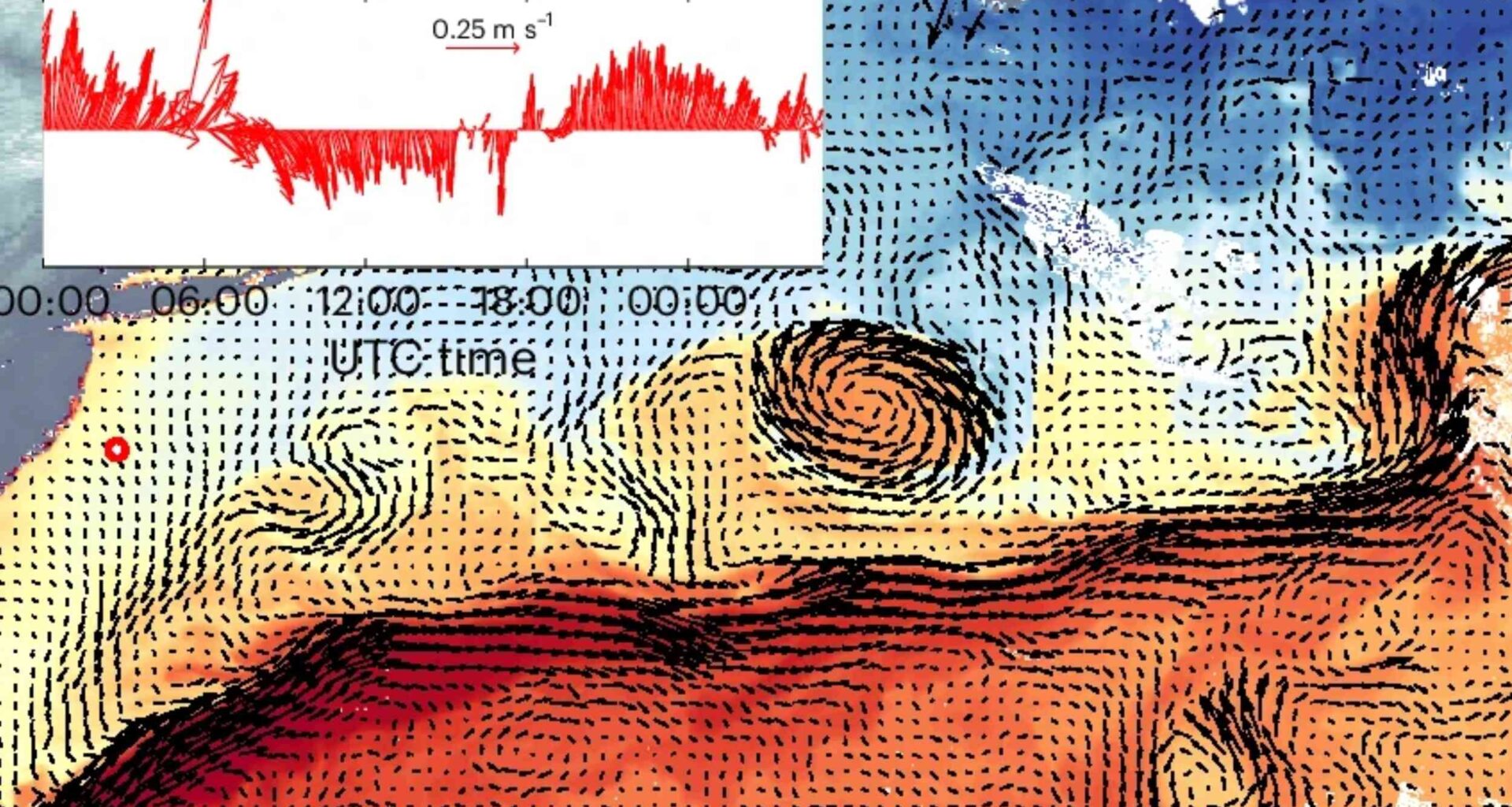
On thermal images of the North Atlantic, warm and cool streaks wrapped through the Gulf Stream in patterns that changed within hours.
At UC San Diego’s Scripps Institution of Oceanography (Scripps), Luc Lenain recognized those shifting fronts as clues to the current below.
Instead of adding a new satellite, the team treated weather imagery as a time-lapse record of water being pushed, bent, and stretched.
That choice matters because the pictures can arrive every five minutes in GOES-East, creating evidence between cloud breaks.
Gaps in ocean mapping
Older altimetry, a way of measuring sea height from space, tracks sea level, but many orbital passes return every ten days.
Meanwhile, the Surface Water and Ocean Topography mission brings finer detail yet still works on a 21-day repeat orbit.
Between those visits, some currents stay narrower than six miles (10 kilometers) and reorganize so quickly that averaged maps smooth them away.
Missing that motion leaves scientists blind at the scales where vertical mixing – water moving between surface and deeper layers – matters most.
Learning ocean motion
To build GOFLOW, the team fed three hourly thermal snapshots into software that predicted the current at the middle hour.
Using deep learning, software that learns patterns from many examples, the system linked moving temperature fronts to water velocity.
Training came from a high-resolution ocean simulation, where the model could compare visible temperature patterns with the motions that produced them.
“Weather satellites have been observing the ocean surface for years,” said Lenain.
Checks on water
During 2023 cruises in the Gulf Stream, researchers checked the maps against shipboard current measurements taken near the surface.
Along those tracks, GOFLOW agreed with the ship data and with satellite products, while adding much sharper local structure.
Where older maps returned blurry averages, the new method pulled out fast eddies and boundary layers that change within hours.
Such agreement suggests the system learned physical motion rather than merely copying quirks from its training simulation.
Hidden ocean patterns
Those sharper maps did more than look better, they exposed statistics of small currents that satellites had not measured before.
In those fields, vorticity, the local spin of moving water, piled up unevenly instead of spreading smoothly across the region.
Comparable asymmetries had mostly appeared in high-resolution simulations, so seeing them from space changed the level of confidence.
“This opens a range of exciting possibilities in physical oceanography that, until now, were largely accessible only through simulations,” said Lenain.
Mixing changes everything
Small currents matter because they move heat, carbon, nutrients, pollutants, and floating debris through the upper ocean.
As nearby flows pull apart or crowd together, divergence – a measure of local spreading or squeezing – helps set where water rises or sinks.
Those exchanges help feed marine ecosystems and carry carbon away from the surface, where the atmosphere cannot reclaim it quickly.
Better current maps could therefore sharpen forecasts for spills, drifting debris, heat exchange with the air, and marine habitat conditions.
Clouds still block
One stubborn limit remains, because clouds hide the thermal surface patterns the system needs to follow.
Across the global ocean, cloud cover blocks roughly 67% to 72% of the view at any moment.
Even so, the researchers still matched ship measurements during heavily cloudy periods, when short openings exposed enough useful features.
Next versions aim to blend radiometers, sensors that read microwave energy, with altimeters so the maps stay connected longer.
A wider watch
Beyond the Gulf Stream, the approach could turn other weather satellites into current trackers over wide stretches of ocean.
Because geostationary satellites, spacecraft that keep watching the same region, do not move past and vanish, they can follow change as it happens.
That persistence may help forecast marine debris, rescue paths, and local heat and gas exchanges that evolve far faster than daily maps.
Since the method uses hardware already in orbit, adopting it should cost far less than launching a new observing system.
Future of ocean tracking
Researchers are now pushing the method beyond one Atlantic region and trying to extend it across the globe.
So far, the training depended on a high-resolution model from a limited region, which leaves open how broadly it transfers.
Another challenge comes from Earth’s curvature, because a system trained on small flat patches does not naturally scale pole to pole.
Releasing code and data publicly should speed those tests and show where the approach holds up or needs revision.
Faster ocean tracking
Weather satellites now function as a practical network for watching ocean motion unfold hour by hour.
Whether the maps become routine worldwide will depend on cloud-resistant inputs, broader training, and continued checks against real water.
The study is published in Nature.
—–
Like what you read? Subscribe to our newsletter for engaging articles, exclusive content, and the latest updates.
Check us out on EarthSnap, a free app brought to you by Eric Ralls and Earth.com.
—–