
Scientists have identified a 310-mile tectonic plate boundary near East Africa’s coast, where earthquakes likely shook ground crossed by dinosaurs.
The discovery redraws a missing edge of a vanished supercontinent and sharpens forecasts of how continents may move in the far future.
Fault under old coast

Beneath East Africa’s coastal rocks, the Rovuma Transform Margin cuts through buried crust as an ancient line where plates slid past each other.
By reading underground images and satellite measurements of Earth’s pull, Dr. Jordan Phethean, senior lecturer in Earth Sciences at University of Derby, traced the hidden boundary through the coastal basin.
The boundary’s tighter path changes the shape of the breakup that opened ocean space beside East Africa.
That revised path sets up a deeper question about what kind of break this was and how violently it moved.
Reading buried motion
The buried boundary acted like a transform boundary, a plate edge where crust slides sideways, rather than a broad stretching zone.
Sound waves bounced off buried layers and revealed steep rock faces, while satellites sensed gravity changes caused by dense crust below.
Those signals showed the crust thinning by as much as 18 miles across only about 10.5 miles.
Such a sharp drop points to plates shearing past each other, not continents slowly pulling apart across a wide belt.
Why the break matters
A long break in rock can preserve motion long after the moving plates have vanished into the new ocean floor.
Across that margin, the buried edge runs north-northwest to south-southeast and stretches more than 310 miles.
That path helped separate landmasses once joined in Gondwana, a former supercontinent made of southern continents.
Its position gives scientists a stronger starting point for maps that roll continental motion backward and forward through deep time.
When Gondwana split
About 180 million years ago, Gondwana began opening along East Africa as dinosaurs still dominated land ecosystems.
The eastern block moved away from Africa, and the sliding edge helped steer the breakup for tens of millions of years.
Earthquakes along that fault zone likely shook the ground in bursts for more than 50 million years.
No one can measure those vanished quakes directly, but the size of the structure shows they were not minor local events.
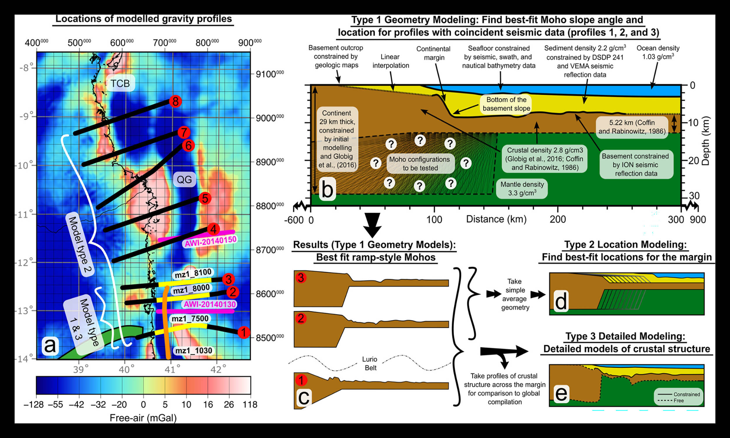 Location of seismic and gravity profiles and summary of gravity modeling methods. Credit: Tectonics (2025). Click image to enlarge.A boundary misplaced
For decades, geologists argued over the continent-ocean transition, the zone where continental crust gives way to ocean crust.
“A debate about the precise location of the continent-ocean transition and what the structure of Earth was in this location has been ongoing since the 1980s, so this discovery puts that argument to bed,” said Phethean.
Older models often placed that transition near the Davie Fracture Zone, a long seafloor break farther offshore.
The new location moves the ancient continental edge landward, closer to the coast of Mozambique and Tanzania, two countries in East Africa.
Clues inside crust
Deep below the seafloor, the base of the crust drops at angles up to 83 degrees in places.
That steep base forms when strong blocks slide past one another and leave little room for broad faulted valleys.
Some nearby crust may be extremely thin, and in places mantle rock, hot material below the crust, may sit close beneath the sediment.
Those clues fit a transform margin, a continental edge shaped by sideways motion, but gravity records alone cannot prove every buried rock type.
Resources beneath sea
Offshore margins often guide resources because stretched, buried, or heated rocks control where fluids and heat collect.
Near Rovuma Basin, a coastal area filled with sediment, the new boundary helps explain why offshore resources cluster in the region.
Stranded fragments of ancient continents may host useful minerals, while geothermal energy, power drawn from heat inside Earth, could come from warm rock.
The same underground maps can also guide carbon storage, trapping captured gas in rock, where greenhouse gases must stay sealed below layers.
Future planet models
Plate maps of the future depend on knowing where old plate edges once carried motion.
A misplaced boundary can send reconstructions off track, especially when scientists project land positions millions of years ahead.
“Our findings will allow us to better understand plate motions and predict what the planet might look like millions of years into the future,” said Phethean.
Future coastlines, climates, and resource access all depend on the slow rearrangement of continents and oceans.
Limits of certainty
The discovery strengthens one version of East Africa’s past, but it does not erase every unknown beneath the seabed.
Gravity measurements reveal mass differences, not names of rocks, so scientists still compare several possible underground layouts.
Seismic images cover key lines across the margin, while gaps remain where no clear underground picture exists.
Even with those limits, the same evidence points repeatedly to a narrow, steep, sideways-moving boundary.
What the finding changes
A hidden plate edge beside East Africa now links dinosaur-age earthquakes, Gondwana’s breakup, and today’s search for underground resources.
Better maps of this boundary can improve future plate models, but new ocean surveys must test the places still hidden.
The study is published in Tectonics.
—–
Like what you read? Subscribe to our newsletter for engaging articles, exclusive content, and the latest updates.
Check us out on EarthSnap, a free app brought to you by Eric Ralls and Earth.com.
—–