
US satellite firm Vantor has shown off its advanced imaging capabilities by sharing images of “one of China’s most strategically important military bases.”
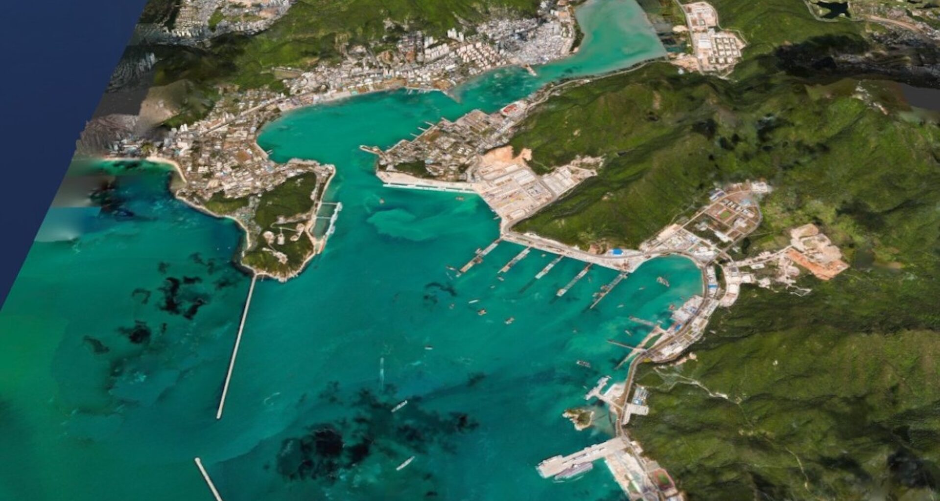
In a post on X, the company published high-detail images of China’s Yulin Naval Base on Hainan Island. Vantor claims its images have a resolution of 50cm and sub-4-meter spatial accuracy.
Impressively, this accuracy was achieved with only one satellite pass, and the image was processed in less than 10 hours. This capability provides customers with a strategic military advantage and impressive visibility that is unattainable using traditional satellite imagery.
Vantor’s impressive satellite imaging capabilities
Advanced satellite imagery makes key military intel accessible from space. Though satellites provide fast coverage, data processing can slow things down. According to a report from Tom’s Hardware, it can take a team of experts days or even weeks to pore over the details.
Vantor aims to speed up this process with AI. The company’s software allows its clients to build a digital twin of a site. This could have widespread applications in military strategy, disaster response, and urban development.
To showcase its system, Vantor has released images of China’s Yulin Naval Base. According to Vantor, the image shows the construction of a dry dock and new quays and piers at one of China’s most strategically important bases.
“We generated this high-resolution 3D terrain from a single satellite pass at 11:21 a.m. local time today, processing it into this finished image within 10 hours. All delivered in 50 cm resolution and at sub-4 m spatial accuracy,” the company said in its post.
In a follow-up post, it added that “command systems and autonomous platforms rely on our highly accurate 3D spatial foundation to serve as a trusted ground truth for the operational terrain. Our rapid 3D processing capability updates this foundation with only a single satellite pass, keeping that foundation current at mission tempo.”
Vantor’s AI-powered spatial intelligence platform
The impressive pixel accuracy in Vantor’s image means that a single pixel covers 50 x 50 cm. As Vantor shows with its post, this is sharp enough to image individual patrol boats.
Vantor was formerly called Maxar. The company is known for sharing imagery of the war in Ukraine and numerous natural disasters. In October, Maxar Technologies announced it had rebranded as Vantor. It also revealed Tensorglobe, an AI-powered spatial intelligence platform.
“The rebrand represents the culmination of the company’s multi-year journey to productize its core operational technology and transform from a satellite imagery provider into an end-to-end spatial intelligence company,” the company explained in a press statement, following the rebrand. Vantor claims that Tensorglobe provides real-time, up-to-date 3D imagery and intelligence around the clock for its military customers.