
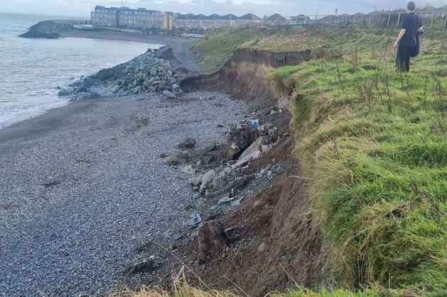
The documents, prepared by consultants RPS, form part of ongoing work to assess whether and how the popular coastal route could be reopened after being closed since a rockfall in 2021. However, rather than identifying a permanent engineering fix, the reports repeatedly treat erosion as an unavoidable baseline condition that must be managed over time.
For the first time, engineers have applied a quantified long-term regression model to the full length of the cliffs overlooking Greystones North Beach.
Based on historical erosion data, recent inspections and a worst-case allowance for increasing storm intensity, the consultants applied an annual retreat rate of up to 0.39 metres per year. The modelling explicitly assumes that no additional bedrock protection will be encountered and that erosion at the base of the cliffs will continue.
Rather than projecting a scenario in which the cliff line is stabilised in its current position, the analysis assumes steady inland movement of the cliff edge over time, until the slopes flatten naturally to a more stable inclination.
The reports describe a cyclical process in which wave action erodes the toe of the slope, increasing its steepness until collapse occurs, followed by further regression. Engineers note that this results in frequent small slumps and larger episodic failures occurring every few years.
While the modelling does not attempt to predict the precise timing of individual collapses, it frames long-term land loss as inevitable. Stability, as defined by the engineers, is achieved only once sufficient erosion has taken place.
That approach represents a significant shift in emphasis. Rather than modelling a once-off solution capable of “fixing” the cliffs, the documents assume continued retreat as a given condition.
The tone of the reports is reinforced by post storm inspections carried out in February 2026, following periods of severe weather along the east coast because of Storm Chandra.
In correspondence to the council, included in the FOI material, engineers warned that landslide features close to the path represent “a significant risk to the path and any persons using the path”, adding that while it cannot be predicted when these features may collapse, “they will in time collapse”.
Engineers also note that, because it was not safe to access all sections of the sea cliffs, they cannot discount the likelihood that further unidentified instability is present along the route.
In assessing what constitutes a stable cliff slope, the reports state that current inclinations are generally too steep for the materials present, particularly Irish Sea Till, which is described as susceptible to softening and failure when exposed.
Based on material testing and comparable infrastructure projects, engineers adopt a stable slope angle of 25 degrees for future modelling. However, achieving that angle requires the cliff to regress inland.
In practical terms, the reports accept that stability is reached not by holding the existing cliff line in place, but by allowing erosion and collapse to continue until a gentler profile is formed.
This assumption aligns with managed retreat approaches increasingly used in coastal engineering, where authorities accept ongoing land loss rather than attempting to permanently defend eroding shorelines.
The FOI material also includes a technical assessment of a footbridge along the closed walk near to where the route crosses the Kilruddery Stream.
A visual inspection carried out in February 2026 found the bridge structure itself to be in generally good condition. However, engineers identified significant erosion of the stream channel beneath it.
According to the report, the stream bed has eroded to around 1.5 metres below the visible level of the bridge abutments. The founding depth of those abutments is not known, but engineers consider it likely they sit above the current base of the channel, creating a risk of undermining if erosion continues.
Inspectors also observed evidence suggesting floodwaters may approach the underside of the bridge deck during extreme weather events, increasing the likelihood of further erosion.
While the bridge has not been declared unsafe, consultants warned that protective works would be required to prevent continued scour beneath the structure if it is to remain in use.
Engineers outlined several options for protecting the stream channel beneath the bridge, including rock armour, reinforced concrete channels and boxed culverts. However, they cautioned that erosion is expected to continue over time even with such measures in place.
The technical note explicitly states that the stream is likely to erode below any protective measures over time, meaning routine inspection and replacement would be required. That acknowledgement mirrors the wider findings on the cliffs themselves, where engineering interventions are framed as management measures rather than permanent solutions.
Wicklow County Council continues to work with consultants on further investigations, including rope access surveys, drone inspections and ecological assessments. Engineering and environmental assessments are also ongoing in relation to potential new access arrangements from Greystones North Beach.
Funded by the Local Democracy Reporting Scheme