
Winter did not quietly fade away in southern Alaska this year. Instead, it pushed through its final days with cold air, steady snow, and a sky that told a complex story.
Offshore, the atmosphere arranged itself into striking patterns that revealed how unstable the air had become.
From space, the scene looked almost organized, but it was anything but calm. Winds, temperature contrasts, and ocean heat were all working together, shaping clouds into distinct forms that stretched across the Gulf of Alaska.
A sky shaped by cold and warmth
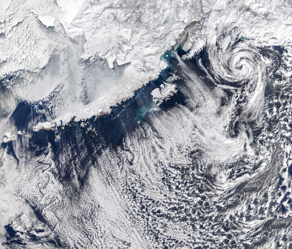
The image was captured on March 19, 2026, the last day of astronomical winter.
On that day, a specific weather setup drove the unusual cloud formations. Low pressure settled over the Gulf of Alaska while high pressure built over eastern Russia and northern Alaska.
That contrast forced cold Arctic air to pour southeast across the Alaska Peninsula. As the frigid air moved over the relatively warmer ocean, it began to change.
It picked up heat and moisture from the water below, setting the stage for cloud formation.
At first, the air remained too dry and cold to form clouds. That is why the region close to shore appears mostly clear.
As the air traveled farther over the water, it gradually warmed and moistened, allowing clouds to take shape.
Cloud streets and shifting patterns
Farther out over the gulf, long parallel bands of clouds began to appear. These are known as cloud streets.
They form when rising warm air creates lines of clouds, while cooler air sinks in between, leaving clear gaps.
The result is a striped pattern that follows the direction of the wind.
These bands can stretch for miles and often signal strong interactions between the ocean and the atmosphere.
As conditions continued to evolve, the cloud streets began to break apart. They transformed into open-cell clouds, which look like thin, wispy edges surrounding empty spaces.
This shift reflects changes in temperature and moisture as the air mass continues to move and mix.
Swirls behind the islands
Not all of the patterns formed in straight lines. Near Unimak Island, part of the Aleutian chain, the clouds took on a swirling appearance.
These rotating trails formed as winds flowed around the island’s elevated terrain.
As air moves past an obstacle like an island, it can begin to spin, creating repeating vortices. These are known as von Kármán vortex streets.
They appear as staggered, counter-rotating swirls that extend downwind, almost like a wake behind a moving object.
These patterns are a reminder that even small landforms can have a large effect on the atmosphere.
The shape and height of the island influence how the air flows, creating these visible signatures in the clouds.
A powerful system offshore
One of the most dramatic features in the image sits about 180 miles southwest of Anchorage. There, a large spiral of clouds marks the presence of a polar low.
Meteorologist Matthew Cappucci described the system as a polar low, noting that it carried tropical storm-force winds and produced snow and thunderstorms around its center.
Polar lows are compact but intense weather systems. They form when very cold air moves over warmer ocean water, creating strong instability.
While smaller than typical storms, they can pack a punch, bringing sudden changes in weather over short distances.
A winter that lingered
March did not bring an early break from winter conditions. Instead, the month was marked by persistent cold and repeated storms across Alaska.
Snowfall and below-normal temperatures held on longer than many expected.
By late April, conditions began to shift. Warmer air moved in, but the change did not bring calm weather.
Reports pointed to continued unsettled conditions, with rain and wind affecting Southcentral and Southeast Alaska.
An approaching atmospheric river added to the instability, delivering moisture that kept the region wet and active. Even as temperatures rose, the atmosphere remained restless.
What the clouds reveal
Cloud patterns like these are more than just visually striking. They offer a window into how the atmosphere behaves.
Each formation reflects a balance between temperature, moisture, wind, and geography.
From straight cloud streets to swirling vortices and compact storms, the sky over southern Alaska captured a wide range of atmospheric processes in a single moment.
It shows how quickly conditions can shift when cold air meets warmer water.
Seen from above, the patterns appear orderly. Up close, they represent a constantly changing system driven by energy moving through the air and ocean.
Image Credit: NASA Earth Observatory
—–
Like what you read? Subscribe to our newsletter for engaging articles, exclusive content, and the latest updates.
Check us out on EarthSnap, a free app brought to you by Eric Ralls and Earth.com.
—–