
B.C. (Bart) Root, Assistant Professor at Delft University of Technology explores how Earth’s gravity field is constantly changing and what these variations reveal about our planet
Everyone has experienced gravity, heard about the falling apple, and knows that gravity governs the motion of planets around our Sun. A static phenomenon that is always present, constant and not changing at all. You could not be further from the truth!
Our Earth’s gravity field is full of regions with high and low gravitational attraction. Moreover, this field changes over time. Scientists use these characteristics to probe deep inside our home planet to reveal the inner workings of Earth.
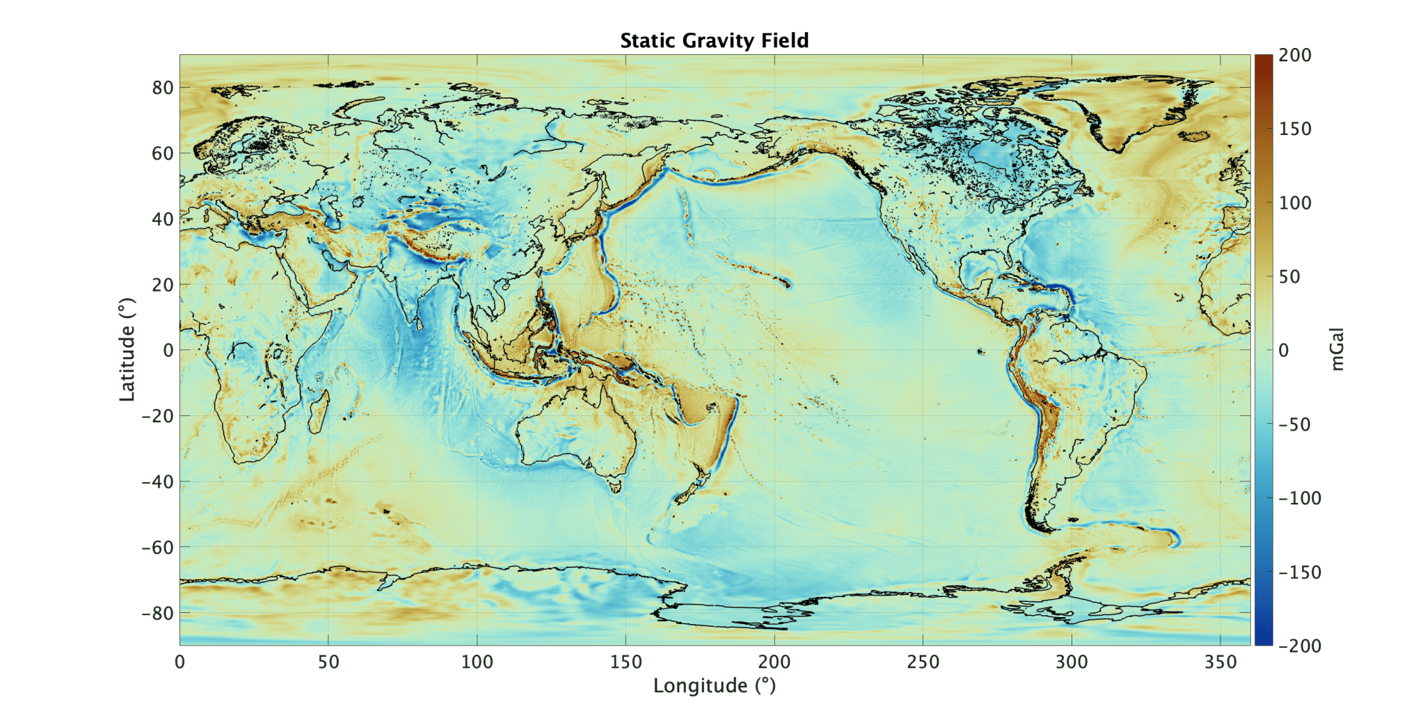
The static gravity field reveals deep structures below our feet
Between 1920 and 1956, Dutch professor F.A. Vening Meinesz demonstrated aboard submarines that the Earth’s oceans contain gravitational anomalies similar to those observed on continents. These gravitational anomalies correlated somewhat with the oceanic floor topography, also called bathymetry. However, the observations revealed hidden mass structures below the surface that later were linked to the global plate tectonics theory. Gravity observations are a great geophysical tool to study the geology of Earth.
The following decades the gravity field of Earth was mapped and with the coming of the satellite era, global coverage and homogenous accuracy, made these maps a useful tool for scientific exploration, engineering solutions, and global monitoring applications. With ESA’s first Earth Explore mission, the Global Ocean Circulation Experiment (GOCE), a high detailed gravity map helped in revealing the ocean currents in much more detail than before. This gave crucial information to oceanographers for years to come.
The red anomalies in a static gravity map show slightly higher concentration of gravity (and therefore mass) with respect to the average gravity field, whereas blue regions show slightly lower concentrations. The plate boundaries are clearly visible, by strong red/blue elongated anomalies along convergent margin. Mountainous belts are also clearly visible, such as the Himalaya and the Andes mountain ranges. Large patches of moderate gravity anomalies are thought to be linked to mantle convection in the deep Earth. Such maps contain huge amount of information and detail still used in exploring the deep Earth.
 ©Delft University of Technology
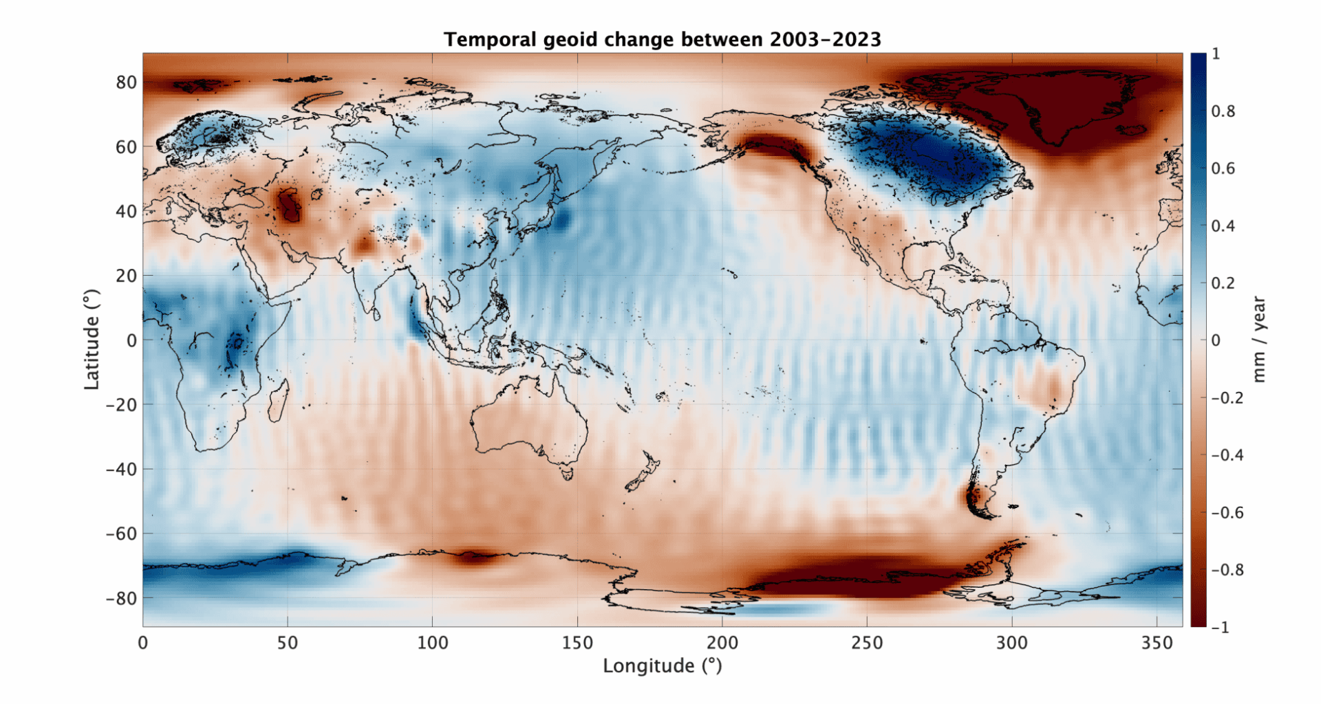
Temporal gravity field observations see ice melt as the strongest signal
Another dedicated gravity mission is NASA’s Gravity Recovery and Climate Experiment (GRACE). These twin satellites follow each other and by measuring their changing distance, scientists can recover the gravity field anomalies with great precision. The satellites can make a global overview of Earth’s gravity field within one month. This opens an extraordinary opportunity, because it allows to capture changes in the gravity field.
Basically, every month the GRACE (and later the GRACE-FO) mission builds a new frame for the gravity field ‘movie’. Putting all these frames together, we can observe periodic and secular changes in the gravity field. These long-term changes of the gravity field show various surface mass transport of our home planet.
The strongest signal is related to ice mass changes in Greenland, Alaska, and Antarctic. The reduction in gravity field is directly related to the melting of the ice sheets and the redistribution of the water over the oceans. Other climatic effects are seen, for example the anomaly at the Kaspian Sea, where prolonged drying up of the region is reducing the gravitational attraction. Effects of local hydrology are seen in the Amazonian basin, Okavango basin, and Volta basin, where prolonged rain have added more water in those systems. Large positive signals are seen over central Canada (Laurentia) and Scandinavia (Fennoscandia) where these signals are correlated with the uplift regions due to paleo-icesheet depressions. After the removal of these ice sheets, the crust is slowly uplifted by inflow of mantle rock, increasing the local mass. One of the most surprising signals were related to the 2004 Sumatra, 2010 Fukushima, and 2011 Chilean earthquakes. The data show local mass displacement due to these catastrophic events. Satellite gravimetry has given us the observations to better understand and maybe even predict these various geophysical events.
Impact of gravity observations are global
An indirect impact of mapping the static gravity field is for oceanography. The geoid, which is a potential field that described the gravity field, is also equal to the ocean surface at rest. So, by correcting altimetry observations with the geoid, all the dynamics happening in the ocean are revealed. This allowed researchers after 2013 (GOCE mission) to study ocean currents with unprecedented precision on a global scale. It made us understand how important ocean currents are in the Earth system.
For climate science the temporal gravity records are of vital importance. It captures the accelerating rate of ice melt, shows basin scale hydrological differences, and monitors the effects of droughts and heavy rain fall. It plays a vital role in many of the IPCC reports as it captures the different mass transport phenomenon with precise data.
In the solid earth community, the static and temporal gravity field are used to probe deep underneath the surface to understand crustal motion, seismicity, sea level change, and even mantle flow. Combined with seismic tomography, electromagnetic probing, and thermal- dynamically consistent minerology it will bring us towards a Digital Twin of the Solid Earth. A tool that will benefit society in understanding the processes below our feet.
Need for prolonged monitoring to understand our home planet
Monitoring of mass transport, like ice melt, GIA, atmosphere and even seismic events are crucial in safeguarding our future. Continuous monitoring of Earth’s ice sheets is of vital importance to understand the effects of warming temperature. The observing of icesheet mass loss with satellites are basically society’s thermometer. Land uplift, which is resurfaced from the water, can skew our climate observations but also bring new land for urban development. Monitoring this process is vital to predict future planning of coastal infrastructure. Other more short period changes of the gravity field can help in understanding atmosphere changes and learn from hazardous events like large earthquakes.
Moreover, longer observation periods would open scientific endeavors that we currently are not able to perform. A very promising application is to use satellite gravity data to observe the tremendously slow motion of mantle flow. The driver behind many surface effects, like plate tectonics, vulcanism, seismicity, and even magnetic core interactions, will soon be studied through this unique dataset.
With the upcoming joint ESA/NASA gravity mission MAGIC, the coming decade promises to transform our understanding of the interior of Earth.