
Deep in Irish waters lies a string of extinct volcanoes that once spewed molten rock on to the trembling seabed and gushed gasses into the convulsing waves.
In another part of Ireland’s marine territory, remarkable canyons have formed that plummet to abyss-like depths of 5.5km.
Elsewhere, there are mounds, cliffs, escarpments, ice age troughs and etchings and other geomorphological marvels so far down, their existence has taken decades to uncover.
It is all evidence of a terrain formed by tremendous forces and so rich in variety that, if it could be seen, would allow Ireland’s seascape to rival some of the most dramatic landscapes on the planet.
“A lot of people think the deep sea is dark and muddy and not a lot goes on there, but that could not be further from the truth,” says Andy Wheeler, professor of geology at University College Cork (UCC). “It’s a wonderful world down there.”
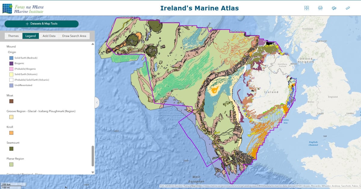
That wonderful world has now, for the first time, been comprehensively mapped and all its features added to the Irish Marine Atlas.
This atlas of the unseen was already a vast resource that captured in detail Ireland’s extensive coastal waters, which themselves can reach a not inconsiderable depth of 200 metres.
But mapping of Ireland’s deepwater seabed has been piecemeal.
Carried out on individual sites at different times over the last 25 years using assorted technologies, it lacked the consistency needed to produce a full, detailed, reliable picture.
 ‘It’s a wonderful world down there,’ says Prof Andrew Wheeler, head of the Marine Geoscience Research Group at University College Cork
The Marine Institute and the Marine Geosciences Research Group at UCC which Wheeler heads, have been working to rectify the situation.
It was not an easy task as Ireland’s marine territory is vast. Ten times the size of the country’s land territory, it stretches at its furthest point to almost 1,000km from shore and at its deepest to more than 5km.
Some of the existing, limited maps dated back 25 years and were of low quality by today’s standards.
The teams from the Marine Institute and UCC had to pull all the pieces together, enhance them to high resolution, reinterpret them, identify any gaps in the jigsaw and make the final product look seamless.
 Fabio Sacchetti, team lead, Advanced Mapping Services at the Marine Institute
The result of their work is, says Fabio Sacchetti, team lead in advanced mapping services at the Marine Institute, “a major scientific achievement”.
It is also, he says, “a valuable resource for Ireland’s sustainable development”.
He’s referring to the fact that the sea and the seabed are increasingly featuring in Government policies and international developments.
Ireland has big ambitions for offshore wind energy and while the five offshore wind projects now in planning will be relatively close to shore and fixed to the seabed, there are longer-term hopes that floating wind farms will be developed far out to sea.
Further into the future, there are aspirations to develop accompanying refuelling platforms that would use the vast power of floating wind energy to produce green hydrogen that could fuel passing ships, almost like a motorway petrol station.
Knowing exactly what would lie beneath such infrastructure is essential.
Already Ireland’s marine territory is crossed by telecommunications cables, pipelines and electricity interconnectors and there are plans for many more. Decisions on their routing will also depend on seabed conditions.
Apart from marine-based infrastructure, the sea is increasingly the focus of concerns around preserving and restoring what remains of the Earth’s struggling nature.
[ European maritime law aims to tighten collective security and environmental focusOpens in new window ]
The issue is increasingly urgent as awareness grows of the vital role healthy seas can play in sequestering carbon and cooling our overheating planet.
Ireland has precious deep-sea habitats, including cold-water coral reefs a kilometre down that suffered badly over decades of bottom trawling by supersized commercial fishing vessels.
These and other natural wonders need protection – and accurate mapping is a critical first step.
Ireland’s long-promised Marine Protected Areas legislation remains a work in progress, but here too, designation and management of protected areas requires good mapping.
At EU level, discussions are also under way on the creation of a European Ocean Act to co-ordinate marine protection from a nature, defence and commercial point of view.
Undoubtedly, there will also be interest from some parties in studying the maps from a seabed mining perspective to gauge the potential for underwater mineral extraction.
The atlas is publicly funded and open to everyone to use.
But setting all that aside, what does the mapping exercise actually reveal about the parts of Ireland we know the least?
Andy Wheeler has difficulty containing his excitement as he lists some of his favourite features.
“There are some incredible submarine canyons at the very south of Ireland’s territory from 200m to 5.5km down,” he says.
“Anything similar on land is ground down and eroded but these are huge. They are Grand Canyon-esque.
“There are also quite a surprising lot of mounds at the far western edge of Ireland’s territory. They’re a series of extinct volcanoes.
“They were last active about 60 million years ago, so similar to the period when the Giant’s Causeway was formed.
“What you also see as you go west is a series of banks and rift valleys, and at the top of the banks there are scours carved into the seabed by icebergs.
“When there was a glaciation, there were icebergs and their keels scoured the rock as they moved.
 EU discussions are under way on the creation of a European Ocean Act to co-ordinate marine protection from a nature, defence and commercial perspective. Photograph: Getty Images
“When you consider the depth of these marks and that nine-tenths of an iceberg is below water, some of these must have been enormous – hundreds of metres tall.”
Wheeler’s enthusiasm is understandable. He has spent much of his career exploring the treasures of the deep sea and trying to metaphorically bring them to the surface for the public to enjoy.
“There is also a whole series of escarpments, some caused by erosion, some by submarine landslides,” he says. “Some of those landslides may have been tsunami-inducing but we don’t know for sure.
“We don’t think there are any likely to go off at present.”
Work on mapping Ireland’s seabed began in earnest in 1999 with the Irish National Seabed Survey and then its successor, the Infomar programme.
Infomar is due to run until 2029, with the final few years focused on expanding and updating the maps in some shallow zones.
The work has been overseen by Geological Survey Ireland and has involved the Marine Institute, numerous surveying vessels, the deep-sea Holland ROV (remotely operated vehicle) and remote sensing technology.
It has been funded by the Department of Climate, Energy and the Environment, and has drawn what the department likes to call “the real map of Ireland” – the island and its seas.
Anyone who wants to delve into it can log on to atlas.marine.ie and start making their way around it.
The datasets are extensive and it takes a bit of time to work out how to select specific areas or features to examine, but the latest additions from Sacchetti, Wheeler and their teams can be found under the heading Irish Deep Seabed Geomorphology 200m-5000m.
Although Wheeler has the benefit of being an expert who knows the maps intimately, he urges novices to give it a go.
“Ireland punches above its weight in ocean exploration and we have a huge territory to explore,” he says. “It’s quite wonderful.”