
The steady flow of Gulf oil shipments to Europe, the United States and Asia through the narrow shipping lanes of the Strait of Hormuz has created the world’s largest oil transit chokepoint.
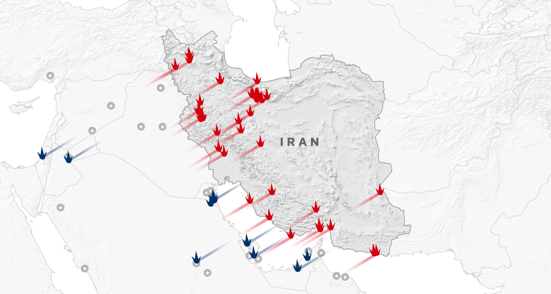
After the United States and Israel launched the most ambitious attack on Iran in decades, Tehran’s ability to disrupt transit in the strait has rattled markets and choked trade.
Already, oil prices have risen sharply and analysts expect them to remain elevated over the coming days while markets focus on the impact of escalating Middle East conflict on supplies through the strait.
More than 20 million barrels of crude, condensate and fuels passed through the strait daily last year on average, data from analytics firm Vortexa showed.
OPEC members Saudi Arabia, Iran, the United Arab Emirates, Kuwait and Iraq export most of their crude via the strait, mainly to Asia.
Qatar, among the world’s biggest liquefied natural gas exporters, sends almost all of its LNG through the strait.
Shipping through the strait between Iran and Oman, which carries around one-fifth of oil consumed globally as well as large quantities of gas, has ground to a near halt after vessels in the area were hit as Iran retaliated to U.S. and Israeli strikes.
Several tanker owners, oil majors and trading houses have suspended crude oil, fuel and liquefied natural gas shipments via the Strait of Hormuz after the U.S. and Israel attacked Iran, trading sources said on Saturday.
“Our ships will stay put for several days,” one top executive at a major trading desk said. Satellite images from tanker trackers showed vessels backed up next to big ports, such as Fujairah in the United Arab Emirates, and not moving through Hormuz.
Iran’s ability to disrupt the strait
Iran has said it closed navigation through the critical waterway, and shipping has ground to a near halt after vessels in the area were hit as Iran retaliated to U.S. and Israeli strikes.
The U.S.-flagged products tanker Stena Imperative was damaged by “aerial impacts” while berthed in the Middle East Gulf, the vessel’s owner Stena Bulk and its U.S. manager Crowley said in a statement, and a shipyard worker was killed as a consequence of the impact.
On Sunday, a projectile hit the Marshall Islands-flagged product tanker MKD VYOM, killing a crew member as the vessel sailed off the coast of Oman, its manager said on Sunday, and two other tankers were also damaged.
Also on Sunday, a projectile hit the Gibraltar-flagged oil bunkering tanker Hercules Star off the UAE coast, manager Peninsula said in a statement. The tanker returned to anchorage in Dubai on Sunday morning and the crew were safe, Peninsula added.
In addition to direct attacks on ships via missiles and drones, Tehran may also deploy mines in the strait.
U.S. intelligence estimates Iran has stockpiled as many as 6,000 mines, including drifting, limpet, bottom and moored mines.
“Floating and naval mines pose a severe asymmetric threat in these confined waters, particularly in the Strait of Hormuz’s narrow transit lanes, where shallow depths and Iran’s coastal positioning enable swift, potentially deniable deployment from fast attack craft, submarines, or other platforms,” said Scarlett Suarez, senior intelligence analyst with UK based maritime risk intelligence and cybersecurity specialists Dryad Global.
“Although no large-scale mining or confirmed mine detections have been reported amid the ongoing crisis, persistent threats and the potential for partial or targeted use remain credible.”