
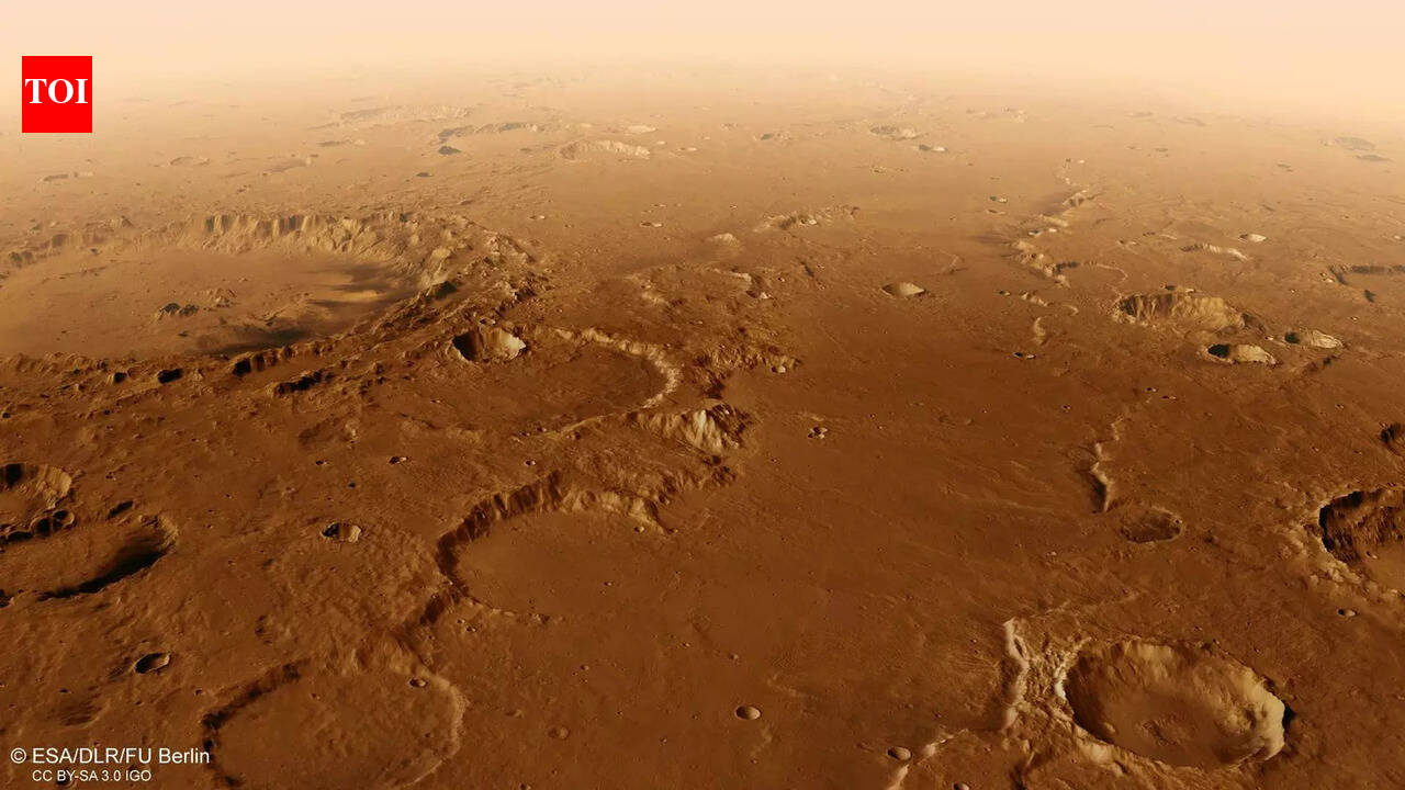
") ESA releases high resolution bird eye view of Flaugergues Crater on Mars (Image Source – ESA) The European Space Agency has released a new flyover video that traces part of Mars’s southern highlands, offering a slow, close look at one of the planet’s most heavily cratered regions. The footage focuses on Flaugergues Crater and its surrounding terrain, built entirely from real spacecraft data rather than artistic reconstruction. Created using images and elevation measurements from the Mars Express mission, the video shows how deeply scarred and uneven this part of Mars remains. Subtle lighting, added haze and controlled camera motion give a sense of scale without dramatising the landscape. What emerges is not a spectacle but a measured visual record, shaped by geology, time and careful processing rather than imagination.
ESA releases high resolution bird eye view of Flaugergues Crater on Mars (Image Source – ESA) The European Space Agency has released a new flyover video that traces part of Mars’s southern highlands, offering a slow, close look at one of the planet’s most heavily cratered regions. The footage focuses on Flaugergues Crater and its surrounding terrain, built entirely from real spacecraft data rather than artistic reconstruction. Created using images and elevation measurements from the Mars Express mission, the video shows how deeply scarred and uneven this part of Mars remains. Subtle lighting, added haze and controlled camera motion give a sense of scale without dramatising the landscape. What emerges is not a spectacle but a measured visual record, shaped by geology, time and careful processing rather than imagination.
High resolution imaging by ESA turns Mars’s orbital data into a three dimensional landscape
The video by the European Space Agency draws on data from the High Resolution Stereo Camera aboard Mars Express. The source material comes from the Mars Chart image mosaic, compiled from individual orbital passes. This mosaic is centred near 20 degrees south and 17 degrees east. To turn flat images into depth, the camera data was merged with a digital terrain model. The result is a three dimensional surface that reflects real variations in height across hundreds of kilometres.
Camera motion follows a fixed and measured path
Every second of the video consists of 50 individual frames, each one rendered separately. The camera takes a predetermined path over the landscape with the movement being very smooth and consistent. The vertical relief is exaggerated by a factor of three to make the forms of the land more understandable. If this modification wasn’t done, many slopes and hollows would look flatter than they really are from the space view.
Haze is added to reflect atmospheric limits
Mars has a thin atmosphere, but its effects still shape how the surface is seen from a distance. In the video, a soft haze builds gradually beyond 250 kilometres. This serves two purposes. It mirrors how dust and light scatter on Mars, and it hides the edges of the terrain model. The transition to the horizon feels natural, rather than cut off or artificial.
Graben structures reveal ancient tectonic movement
The flyover begins along a long trench like feature between two steep escarpments known as Scylla Scopulus and Charybdis Scopulus. This formation is a graben, created when the crust pulled apart. It stretches roughly 75 kilometres across and drops about 1 kilometre in depth. The scale becomes clear only as the camera moves steadily along its length.
Large impact craters dominate the surrounding plains
To the left of the initial path lies Bakhuysen Crater, about 150 kilometres wide. As the camera continues north, Flaugergues Crater comes into view. This basin spans roughly 240 kilometres and sits within terrain crowded by impacts of all sizes. Parts of its floor rise sharply, with rugged sections reaching around 1 kilometre in elevation.