
Geologists have shown that a vast canyon lies 621 miles (1,000 kilometers) west of the Iberian Peninsula. It opened 37 million years ago when a temporary boundary between tectonic plates split the Atlantic seafloor from east to west.
That finding recasts one of the ocean’s deepest rifts as the fossil trace of a vanished plate margin, revealing how shifting plate borders can redraw the map of the deep ocean.
A hidden Atlantic canyon

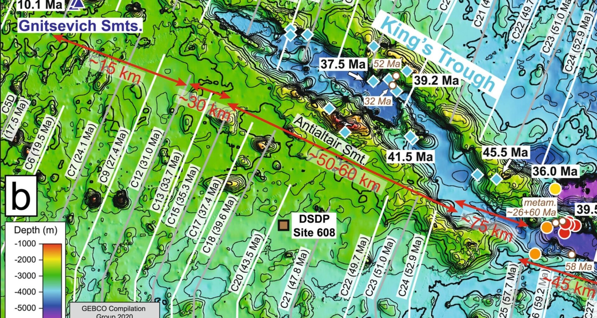
Far out in the North Atlantic, the King’s Trough stretches for 311 miles (500 kilometers) and drops as much as 14,764 feet (4,500 meters), forming a chain of parallel basins and ridges cut into thick ocean crust.
By aligning the ages of volcanic rocks with breaks in the seafloor, Dr. Antje Dürkefälden at GEOMAR Helmholtz Centre for Ocean Research Kiel demonstrated that this structure opened along a short-lived boundary between the African and Eurasian plates.
Those ages show the trough widening progressively from east to west before tectonic forces migrated elsewhere, leaving the canyon stranded in place.
Recognizing that sequence sets up the deeper question of why this particular stretch of crust fractured so dramatically while neighboring regions remained intact.
Where the canyon runs
Far west of Portugal and Spain, the King’s Trough lies about 186 miles (300 kilometers) east of the Mid-Atlantic Ridge.
At the eastern end, Peake and Freen Deeps plunge nearly 19,700 feet (6,000 meters), placing them among the Atlantic’s deepest spots.
Parallel basins and flanking ridges run for hundreds of miles, with some walls rising sharply over short distances.
Such geometry fits ripping and sliding faults better than slow erosion, so the canyon demands a tectonic explanation.
Testing a new explanation
For years, many teams treated the canyon as a simple case of the seafloor stretching as it cooled.
That idea assumed a broad pull apart, with the same force acting across the entire region at once.
However, deep basins lined up in parallel, and the eastern end opened far more than the western end, leaving puzzles behind.
Those mismatches pushed geologists to test whether moving plate borders, not just stretching, had carved the trough.
A moving plate boundary
Plate reconstructions placed the Africa-Eurasia boundary here between 37 and 24 million years ago, then removed it.
As that border arrived, sideways motion and tension opened faults, and the main trough widened along the moving boundary.
At the eastern end of the King’s Trough, in the basins known as the Peake and Freen Deeps, extension cut so deep that magma rose from the underlying mantle and cooled into fresh lava.
Later, plate motion moved elsewhere, rifting stopped, and the King’s Trough Complex became a long record of that moment.
Dating the ocean floor
During the 2020 Meteor cruise, scientists used multibeam sonar to chart seafloor depth, a sonar system that sends sound pulses.
Scientists recorded fan-shaped echoes and calculated seafloor depth from their travel time as the ship moved forward.
Crew members dredged lava from 2 miles (3.2 kilometers) deep, and GEOMAR researchers used argon dating, a clock based on radioactive decay, to read ages.
Those dates lined up with plate reconstructions, showing when rifting started and when it stopped.
Chemical clues in lava
Chemical fingerprints split the lava samples into two camps, and each camp pointed to a different source inside Earth.
In the main trough and nearby seamounts, lavas carried extra trace elements that concentrate in melt, hinting at unusual mantle.
Peake and Freen Deep rocks looked stripped of those extras, matching the ordinary mantle that feeds most ocean ridges.
That contrast let the team separate plume-influenced crust from normal crust, even though both sit in one rift system.
Volcanic roots of fracture
Long before rifting began, heat rising from deep inside Earth thickened the crust, and warm rock broke more easily under stress.
Geologists call that upwelling a mantle plume, a long-lived column of unusually hot rock from below.
That ancient heat source likely fed early Azores volcanism, and today it still affects eruptions around those Portuguese islands.
“Our results now show, for the first time, why this extraordinary structure formed precisely in this location,” said Dr. Dürkefälden.
A boundary jumps south
Around 23 million years ago, plates reorganized, and the boundary moved south to the Azores-Gibraltar fracture zone at the mouth of the Mediterranean.
With stress redirected, faults along King’s Trough stopped slipping, and the canyon began to collect sediments instead of widening.
At the same time, plume-fed magma helped build the Azores Plateau, showing how quickly a hot region can relocate activity.
That pairing between heat and plate motion offers a warning that stable-looking seafloor can hide slow changes below.
Present-day plate motion
Farther south, the Terceira Rift is opening near the Azores, cutting new basins into thick ocean crust.
Oblique stretching and sideways slip break the seafloor into segments, creating deep pockets separated by ridges.
Unlike the fossil canyon, this rift still hosts earthquakes and volcanism, which can reveal how cracks grow over time.
Watching that modern system may test the new model and improve forecasts of where future plate boundaries might form.
The King’s Trough timeline
The King’s Trough Complex now reads like a timeline, linking plate rearrangements with deep heat and sudden seafloor tearing.
Future expeditions can probe deeper and extend mapping across the region to test whether other ocean rifts also began where heat had already weakened the crust.
The study is published in Geochemistry, Geophysics, Geosystems.
—–
Like what you read? Subscribe to our newsletter for engaging articles, exclusive content, and the latest updates.
Check us out on EarthSnap, a free app brought to you by Eric Ralls and Earth.com.
—–