
Tracking floating plastic debris is critical for ocean clean-up efforts. Yet even with large amounts of satellite imagery and weather data available, detecting and following these debris patches remains difficult. A project called AI for Detecting Ocean Plastic Pollution with Tracking (ADOPT) aims to change that. By combining satellite imagery with artificial intelligence, researchers hope to improve how plastic pollution is detected and tracked in the ocean.
A New Approach to a Growing Problem
When plastic pollution is detected, governments and NGOs cannot respond immediately. They need time to organise ships and deploy clean-up equipment. By the time teams arrive, the debris may have already drifted far away. Researchers believe AI could help solve this problem.
The ADOPT team first worked with open-access images from the Sentinel-2 satellites operated by the European Space Agency. These satellites regularly photograph Earth and can capture large areas of the ocean.
However, Sentinel-2 has two important limitations. First, it passes over the same part of the ocean only once every six days. Second, its images have a resolution of about 10 metres per pixel, which makes smaller debris patches difficult to detect.
How AI Finds Plastic from Space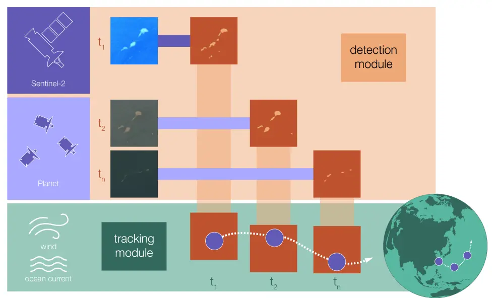 Schematic of the project. The detection tool shown in the top part finds the debris, whereas the tracking module shown in the bottom part predicts where to look for the debris, when images are available again. Credit: SDSC / https://www.datascience.ch/
To overcome these limitations, researchers developed an AI system that also uses data from PlanetScope, a constellation of hundreds of nanosatellites that photograph Earth every day. Their images are also much sharper, with a resolution of 3-5 metres per pixel.
By combining data from both satellite systems, the AI can detect floating debris more reliably. The system automatically analyses new images each day and updates its results without needing manual image labelling.
Predicting Where the Debris Will Drift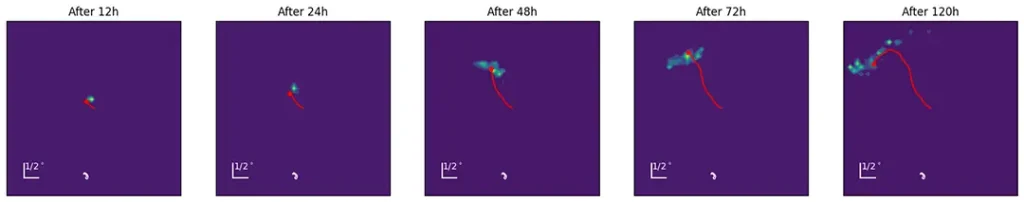 Prediction of a drifting object in the Gulf of Mexico: The red star indicates the true position of the object after 12 to 120 hours since the last observation. The colour map is the probability density, where the ML-based method predicts the object to be. Credit: SDSC / https://www.datascience.ch/
Detecting plastic is only the first step. The next challenge is predicting where it will move before clean-up teams can reach it.
To address this, the researchers developed a second system to forecast the short-term movement of debris patches. The model, created by Christian Donner at the Swiss Data Science Centre (SDSC), combines traditional weather and ocean current forecasts with machine learning.
Standard ocean models already estimate how winds and currents move objects in the sea. However, these models often contain errors. Machine learning helps correct those biases by analysing large amounts of environmental data and improving the predictions.
Because there is limited real-world data about plastic garbage patches, the system was trained using GPS-equipped ocean drifters. These floating instruments, deployed through the Global Drifter Program, have been collecting data on ocean currents since the 1990s.
A Challenge: Clouds and Bad Weather
Despite the progress, the system still faces a major limitation: clouds. The optical sensors used to detect debris cannot see through cloud cover. This means the system may struggle to identify plastic patches during cloudy or stormy weather. One possible solution would be to use radar images from Sentinel-1 satellites. Unlike optical sensors, radar signals can penetrate clouds and operate day and night.
However, radar data provides only basic information about the shape and texture of objects on the ocean surface. It cannot detect the detailed colour signatures that help scientists distinguish plastic from other materials.
For now, the ADOPT team has decided not to combine radar and optical data within the project.
What Happens Next
The two-year ADOPT project will officially conclude this fall. By then, researchers expect to deliver a working proof of concept, two scientific publications, and open-source code for both systems — the debris detection tool and the drift prediction model.
The work is unlikely to stop there. Dutch NGO The Ocean Cleanup plans to continue testing and comparing the algorithms, while university researchers will keep developing the technology in future studies.
If successful, these tools could eventually help clean-up teams locate ocean plastic faster — and intercept it before it spreads even further across the seas.
Published by Space Enthusiast
An amateur rocket enthusiast with a keen interest in all space-related activity. Looking forward to the day when the UK starts launching rockets into space and I’m able to watch launches (from a safe distance of course).