
Article contributors: Jake Shermeyer, Vinicius Perin, Ramesh Nair, and Kirk Bloomquist.
Consider how a digital artist can skillfully improve the quality of a photograph by adding details, and making its features clearer and more distinct. Planet SuperRes does something similar for satellite imagery. It uses artificial intelligence (AI) to analyze our high-quality 3.7 meter (3 m) PlanetScope® imagery and intelligently add a new layer of detail, resulting in 1.2 meter (1 m) resolution tiles at the equator (with fluctuations based on latitude).
This enhancement makes it easier to see and analyze features on the ground, opening up new possibilities for everything from agricultural monitoring to infrastructure management. This article provides an overview of our Planet SuperRes model, highlighting what makes it special, how it can be used, and the scope of its applications. For a deeper dive on the training dataset and model methodology, please see our technical blog post.
What Makes Planet SuperRes Different?
Not all image enhancement tools are created equal. Our model has three key differentiators that set it apart and deliver superior results.
1. A World-Class Training Ground
An AI system is only as good as the data it learns from. We built the Planet120K Super-Resolution Dataset, one of the largest and highest-quality collections of its kind in the world. We meticulously paired over 120,000 of our PlanetScope images with high-resolution (0.5 m) SkySat® images of the same locations, taken at nearly the same time. By training on this massive, detailed dataset, our AI model learned how to predict a higher resolution result from a standard PlanetScope image.
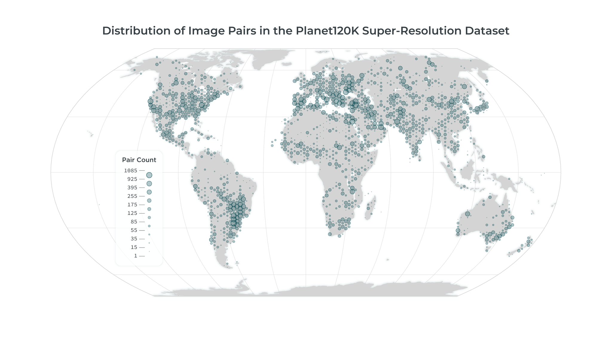
Planet120K Dataset location distribution shown in graduated circles.
2. Trained for the Human Eye
Many AI models are trained to match images as closely as possible at the pixel level, but this often produces results that look blurry. Our model is optimized to create outputs that look sharper and more natural to the human eye. To go beyond pixel-matching, we combine perceptual loss with a generative adversarial approach. Perceptual loss helps the model capture structures and textures in a way that aligns with how people actually see, while the adversarial training sharpens fine details that would otherwise be lost. Together, these methods produce images that are both crisp and natural to the human eye.

3. The Confidence Layer: A Built-in Score
This is a unique feature. Planet SuperRes doesn’t just give you a sharper image; it also provides an accompanying Confidence Layer. This layer highlights those parts of the image the model is very sure about and which parts of it may be generating “hallucinations.”
What are hallucinations? In AI, a hallucination isn’t a random error. It’s the model’s best-educated guess to fill in details when the original image lacks enough information for a definitive answer. For example, it might render a plausible shape for a truck in a distant parking lot. The Confidence Layer helps you know when the model is reporting observed facts versus making these educated inferences.
This transparency is revolutionary, as it allows you to easily assess the output and quickly identify where you should apply more scrutiny.

Example of hallucinations and Confidence Layer.
Visual Use Cases
Seeing is Believing: Visual Use Cases for Planet SuperRes
The added clarity from Planet SuperRes makes visual analysis faster, easier, and more reliable.
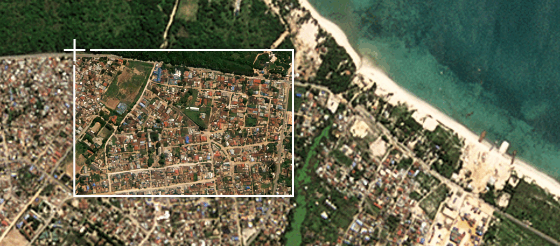
Enhancing urban and man-made structures: In dense urban areas, the model can sharpen large buildings so well that text on rooftops becomes legible where it was previously indistinct. It excels at defining sharp corners, clean lines, and distinct shadows on infrastructure.

In these PlanetScope images of the Chase Center in San Francisco, CA, the SuperRes version on the right makes text legible.

SuperRes also adds clarity to urban areas, as seen in these images of Dar Es Salaam, Tanzania.
Bringing Clarity to Natural Landscapes: In forested areas, a green canopy resolves into a collection of individual trees. In agriculture, the boundaries between crop fields become much clearer, helping to identify different crop types or irrigation patterns.

SuperRes makes individual trees and tree lines more easily distinguished.
How to Access Planet SuperRes
Note that Planet SuperRes is currently in a limited Early Access Program. The delivery information below is subject to change as we refine the product with our early access participants. Please reach out to your Planet customer success manager if you’d like more information.
We are excited to bring Planet SuperRes to our customers in two flexible ways:
1. Planet SuperRes Visual Basemaps
Just as our existing PlanetScope visual basemaps stitch together the best cloud-free data into seamless mosaics, we will now offer basemaps created from Planet SuperRes imagery. This provides a seamless, high-definition upgrade for any customer who relies on our monthly basemaps for consistent, wide-area monitoring.
2. On-Demand in Planet Insights Platform
For more targeted needs, users will be able to run our Planet SuperRes model on imagery within their data collections in Planet Insights Platform. This gives you the power to enhance specific PlanetScope images over your unique areas of interest, when you need it. This flexibility allows you to apply our most advanced enhancement capabilities on-demand, optimizing your analysis workflows.
Choosing the Right Tool for the Job
Planet SuperRes is a powerful new tool that complements our standard offerings.
Planet SuperRes (1 m)
Standard PlanetScope Product (3 m)
Uses AI to add new, realistic detail.
Provides authentic data captured from PlanetScope.
Ideal for detailed visual analysis of objects.
Suitable for spectral analysis and data fusion.
Renders rich, lifelike textures in landscapes.
Utilizes traditional sharpening for a crisp look.
An Honest Look: Understanding Our Model’s Limitations
No AI approach is perfect, and it’s crucial to understand where we have identified that the Planet SuperRes model performs best and where it has weaknesses. Being transparent about these limitations allows you to use the imagery effectively.
Where the Model Can Struggle
Small, dense objects: The model has some difficulty with dense clusters of very small objects, like cars in a crowded parking lot. Because the details of these objects are beyond the resolving power of the original 3 m imagery, the AI must infer their shape and can sometimes jumble them together or create distortions.Unusual or irregular structures: The model was trained on a global dataset, so it excels at reconstructing common features. However, for rare or irregularly shaped objects it hasn’t seen often (like unique rural buildings or coastal fish traps), it may struggle to reconstruct them.Subtle textures and patterns: While generally good, the model can sometimes miss very fine, low-contrast patterns, such as faint stripes in a field from a specific tilling practice.
Focusing on Strengths with the Confidence Layer
This is where the Confidence Layer becomes an essential tool. It is specifically designed to flag the problem areas described above. If you see a parking lot or an unusual building highlighted as potential hallucinations on the confidence map, it’s a clear signal from the AI system that you should be cautious in that area.
This allows you to leverage the incredible clarity of Planet SuperRes across vast areas while being aware of the pockets where its performance is limited.
A Commitment to Improvement
We are committed to the continual improvement of Planet SuperRes. This launch marks an important first step, and the model will evolve from here. By listening to customer feedback and analyzing where in the world the product delivers the most value, we will be able to strategically focus our efforts on these areas to ensure future versions are even more powerful and aligned with our customers’ needs.
Clarity, Reliability, and Transparency
Planet SuperRes represents a major leap forward in making satellite imagery more accessible and useful for visual analysis. By combining a world-class training dataset with an AI system trained to replicate what looks best to the human eye, we deliver a product that is both remarkably clear and detailed. Paired with the Confidence Layer, you get not only a sharper view of the world, but also the transparency to help trust what you see.
Interested in learning more? Check out our article, Planet SuperRes: A Technical Overview, for a deep dive into the learning model that supports Planet SuperRes. Or if you have questions, you can send them to super-res@planet.com — we’d love to hear from you!