
July 24, 2026
The NASA-ISRO Synthetic Aperture Radar (NISAR) mission is a groundbreaking Earth
observation initiative providing unprecedented insights into our planet’s
dynamic surfaces. As the world’s first spaceborne radar mission to employ
dual-frequency (L-band and S-band) instrumentation, NISAR utilizes an advanced
12-meter reflector and innovative SweepSAR acquisition technology. This
architecture allows the observatory to achieve an exceptional combination of
wide-swath (~240 km) and high-resolution imaging without traditional coverage
trade-offs. Operating in a 747 km Sun-synchronous orbit, NISAR provides
persistent, all-weather global coverage with a rapid 12-day repeat cycle,
generating a dense time-series of data essential for monitoring rapid
environmental changes, geohazards, and resource management.
The mission is currently in science operations phase, acquiring data across
global observation tracks as per the Reference Observation Plan, with S-band SAR
data being acquired through ISRO ground stations and subsequent data processing,
archival, and dissemination being carried out at the Integrated Multi-Mission
Ground Segment for Earth Observation Satellites (IMGEOS), Shadnagar, NRSC.
Calibration and Validation (Cal/Val) activities are systematically performed
using the PAN India Corner Reflector (CR) network, homogeneous distributed
targets, and selected science targets to establish and maintain baseline
radiometric, geometric, and polarimetric consistency across all acquisition
geometries.
S-Band SAR data Products Release
ISRO has released the NISAR S-Band SAR daily processed data products through
Bhoonidhi, ISRO’S EO data dissemination hub (https://bhoonidhi.nrsc.gov.in).
This data comprises of S band SAR collections over Indian land mass along with
global locations spanning across diverse NISAR science themes.
Onward Processing Release (Cycle 25 Onwards): Starting with
Cycle 25
(commenced July 8, 2026), all acquired S-Band SAR products are
systematically generated from the operational production environment and
made directly available for user download.
Historical Dataset Reprocessing: Datasets acquired prior to
Cycle 25 will
undergo systematic reprocessing in phased manner and will be added to
archives.
Product Version Baseline: Current released datasets are
with Product
Baseline version (Baseline v1.4.0
CRID P00500)
Following S-band SAR data products are being
released
Standard Products
L1-RSLC: Range-Doppler Single Look Complex
L2-GSLC: Geocoded SLC
L2-GCOV: Geocoded Polarimetric Covariance Matrix
Interferometric Products
L1-RIFG: Nearest-Time Interferogram
L1-RUNW: Nearest-Time Unwrapped Interferogram
L2-GUNW: Geocoded Nearest-Time Unwrapped Interferogram
Offset Products
L1-ROFF: Range-Doppler Pixel Offsets
L2-GOFF: Geocoded Pixel Offset Produc
Accessing NISAR data through Bhoonidhi
NISAR data products are disseminated through Bhoonidhi, ISRO’s Earth Observation
data dissemination hub (https://bhoonidhi.nrsc.gov.in).
Registered users can
access the Browse&Order interface to search, visualize, and download available
NISAR products by specifying the area of interest, acquisition period, product
type and NISAR data specify advanced filters. Level-1 and Level-2 products are
available for access for data covering diverse NISAR science themes in
accordance with the ISRO observation plan. Programmatic access is also supported
through the Bhoonidhi API for authorized users. The portal serves as the primary
distribution platform for NISAR S-band data products and a dedicated NISAR
information page is made available containing associated documentation, product
specifications, calibration status, and release updates for users
(https://bhoonidhi.nrsc.gov.in/NISAR).
Calibration Status
The current data product release incorporates the latest radiometric, geometric,
and polarimetric calibrations derived from in-flight Cal/Val activities.
Calibration parameters and algorithm enhancements will continue to evolve over
the operational lifetime of the mission, with updates notified to the user
community as processing baselines advance.
Users may observe residual radiometric banding in low
signal-to-noise ratio (SNR) regions such as oceans, deserts, and other
homogeneous surfaces in this version of products. Although, RFI mitigation has
been applied to all scenes, residual RFI artifacts may still be present in
certain areas, for which improvements are planned in future releases.
Tools at Bhoonidhi for NISAR data
To facilitate seamless data handling and scientific analysis
without extensive local processing overheads, Bhoonidhi provides an integrated
suite of user utilities:
HDF to GTiff Tool: Utility providing format conversion of
NISAR HDF5 datasets
into GeoTIFF and Cloud-Optimized GeoTIFF (COG) formats, with option for
spatial sub-setting by point coordinates or user-defined shapefiles.
SARPOL TOOL: A QGIS-integrated processing suite supporting
NISAR format
conversions along with Hybrid and Full Polarimetric decomposition techniques
for SAR data analysis.
Explore & Access Datasets: Search, visualize, convert,
and download NISAR S-Band products directly on
ISRO’s Bhoonidhi Portal →
https://bhoonidhi.nrsc.gov.in
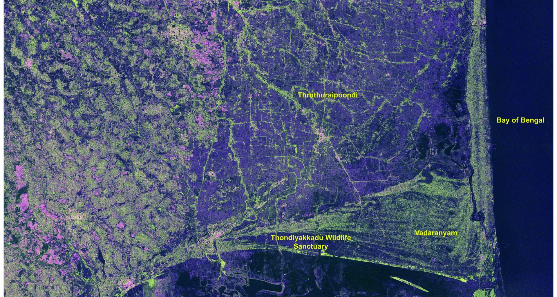
NISAR_S2_PR_GCOV_024_084_A_007_3700_DHNA_A_20260702T001555_20260702T001631_P00500_P_F_I_001
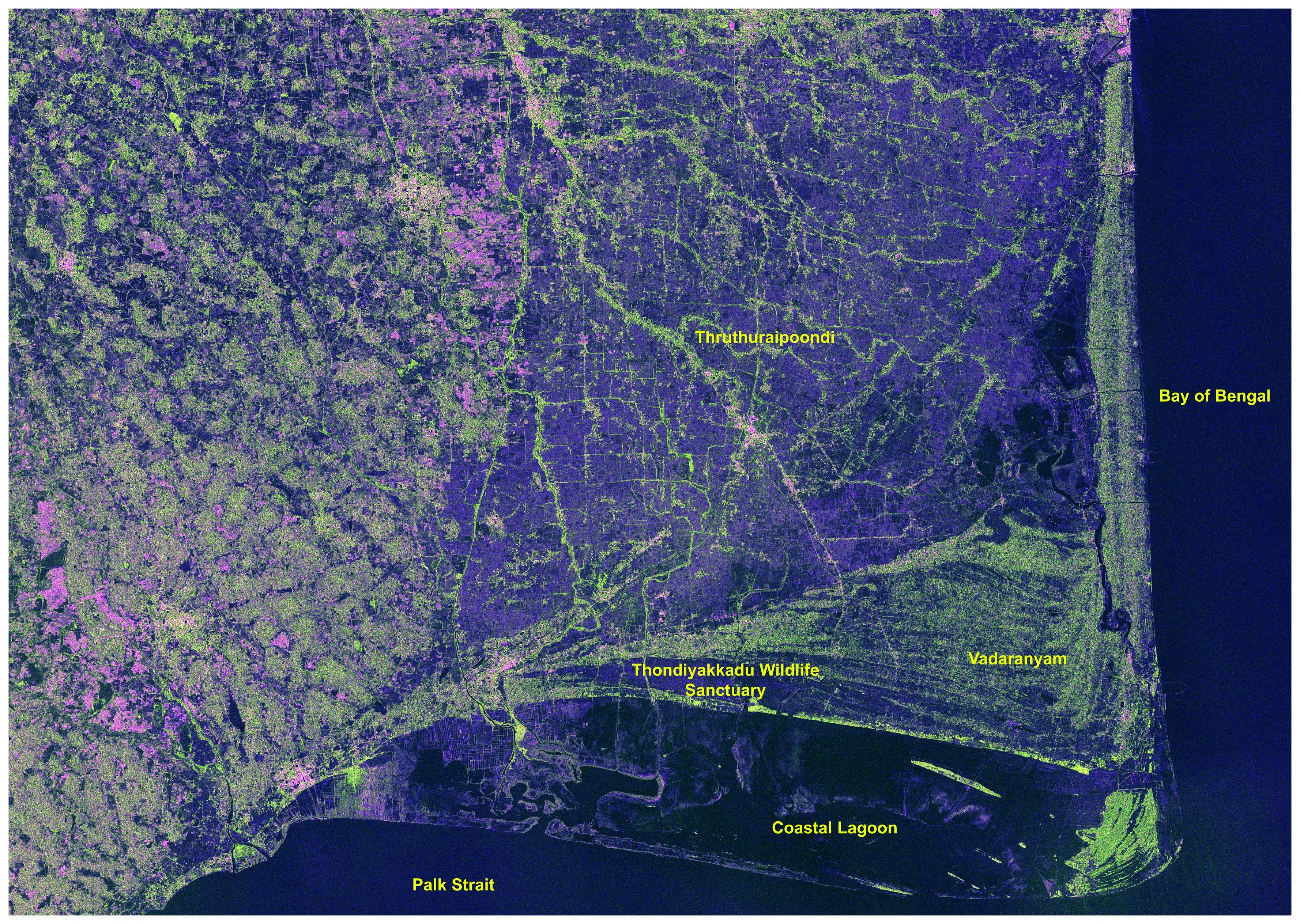
AOI: Nagapattinam
district,
Tamil Nadu
FCC Legend
Red- HH
Green – HV
Blue – HH /
HV
This false-color composite (FCC) derived from NISAR S-SAR data in HH+HV
polarization highlights vegetation (green), land (purple), and water
bodies (dark) across the East coastal region. The composite enhances the
discrimination of mangroves, agricultural fields, wetlands, and coastal
lagoons based on their radar backscatter characteristics. The image was
acquired on 2 July 2026, providing valuable information for coastal
resource management and environmental monitoring.
NISAR_S2_PR_GCOV_025_026_D_125_3700_SHNA_A_20260710T004942_20260710T005015_P00500_M_P_I_001
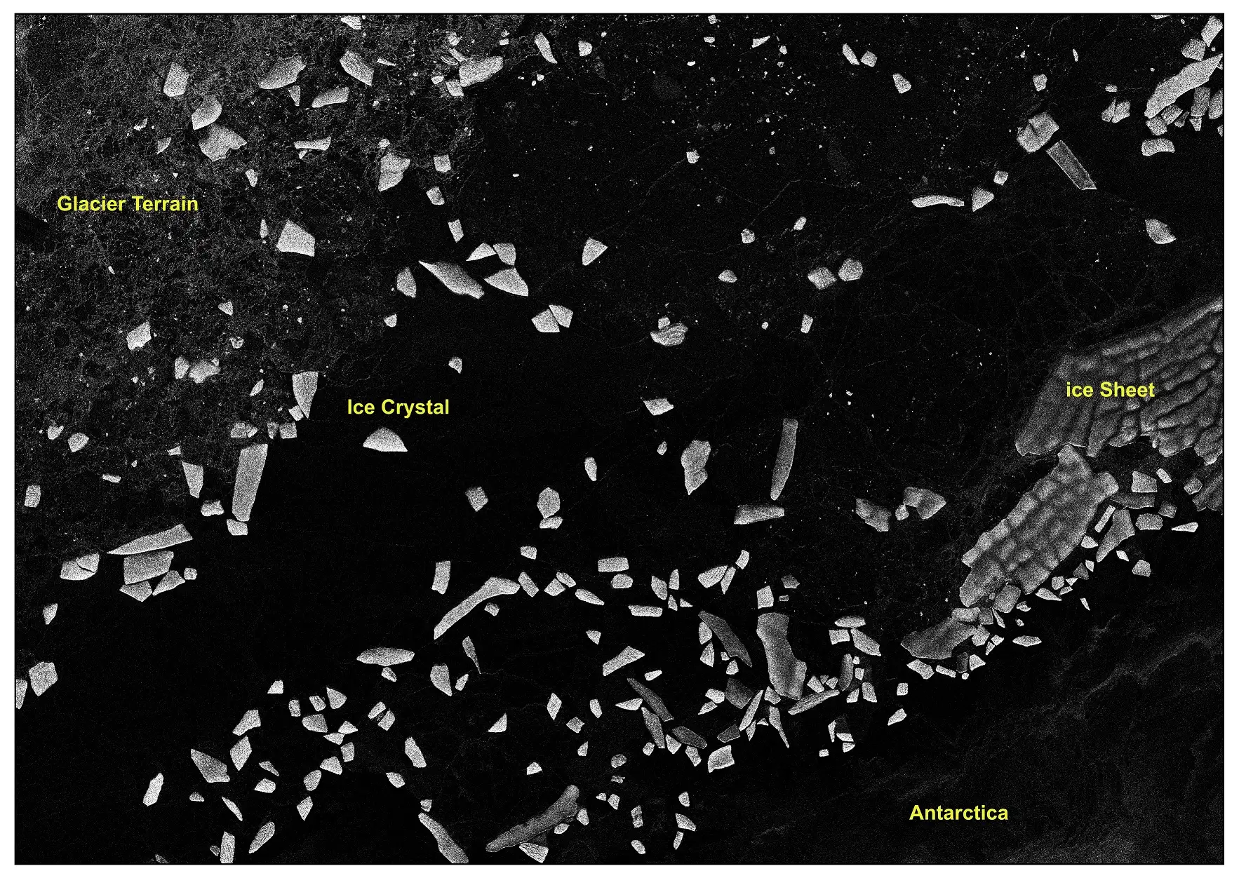
AOI: East, Antarctica
This NISAR S-SAR GCOV image, acquired on 10 July 2026, captures a
coastal region of East Antarctica, showing glacier terrain, an extensive
ice sheet, drifting sea-ice floes, and the surrounding Southern Ocean.
The strong radar backscatter from the ice features contrasts with the
darker open water, enabling clear discrimination of different
cryospheric components. This scene demonstrates the capability of S-band
SAR for monitoring Antarctic ice dynamics, sea-ice distribution, and
glacier–ocean interactions.
NISAR_S2_PR_GCOV_025_019_D_075_2500_CRNA_A_20260709T124208_20260709T124245_P00500_M_F_I_001

AOI: Brahmaputra
River, Assam
Polarimetric
Decomposition Legend
Red – Even
Bounce
Green –
Volume
Blue – Odd
Bounce
This Hybrid Polarimetric M-δ (M-Delta) decomposition image derived from
NISAR S-SAR data captured on 09th July 2026 represents the
Brahmaputra River basin through dominant scattering mechanisms. Surface
scattering (blue) is prominent over the river channels and smooth water
surfaces, double-bounce scattering (red) is associated with built-up
features and vegetation–water interactions, while volume scattering
(green) highlights vegetated floodplains and surrounding forested areas.
The decomposition enhances the characterization of hydrological and
land-cover features, supporting floodplain mapping and environmental
monitoring.
NISAR_S2_PR_GCOV_025_013_D_067_3700_DHNA_A_20260709T023820_20260709T023857_P00500_M_F_I_001
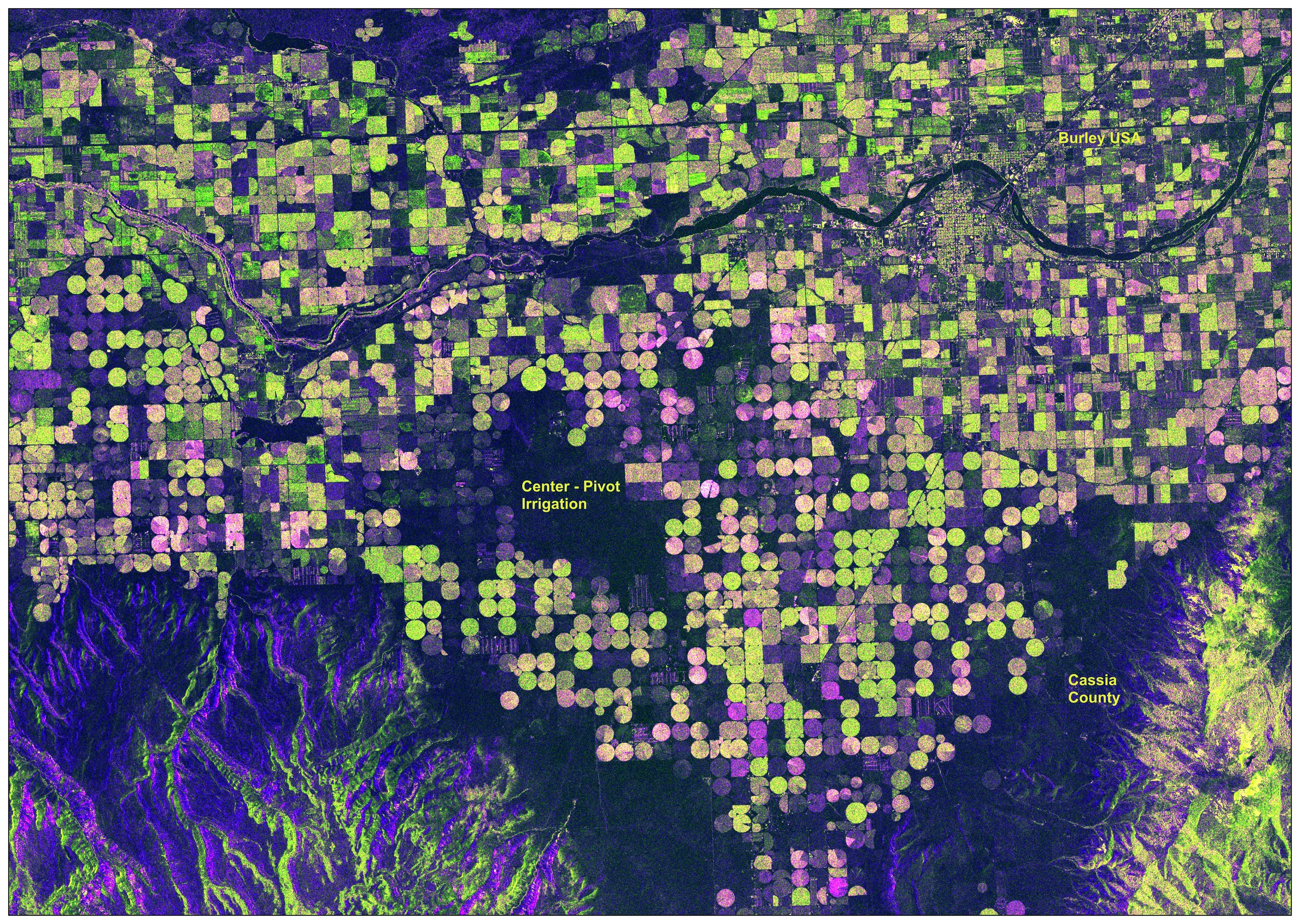
AOI: Idaho, USA
FCC Legend
Red – HH
Green – HV
Blue – HH /
HV
This false-color composite (FCC) derived from NISAR S-SAR data which is
acquired on 09 July 2026 in HH+HV polarization highlights vegetation
(green), cultivated land (purple), and water bodies (dark) across the
Burley agricultural region in Idaho, USA. Variations in radar
backscatter enable clear identification of center-pivot irrigation
systems, agricultural fields, and surrounding terrain. The image
supports precision agriculture, irrigation monitoring, and sustainable
land resource management.
NISAR_S2_PR_GCOV_025_143_A_043_2500_CRNA_A_20260718T024931_20260718T025004_P00500_M_F_I_001
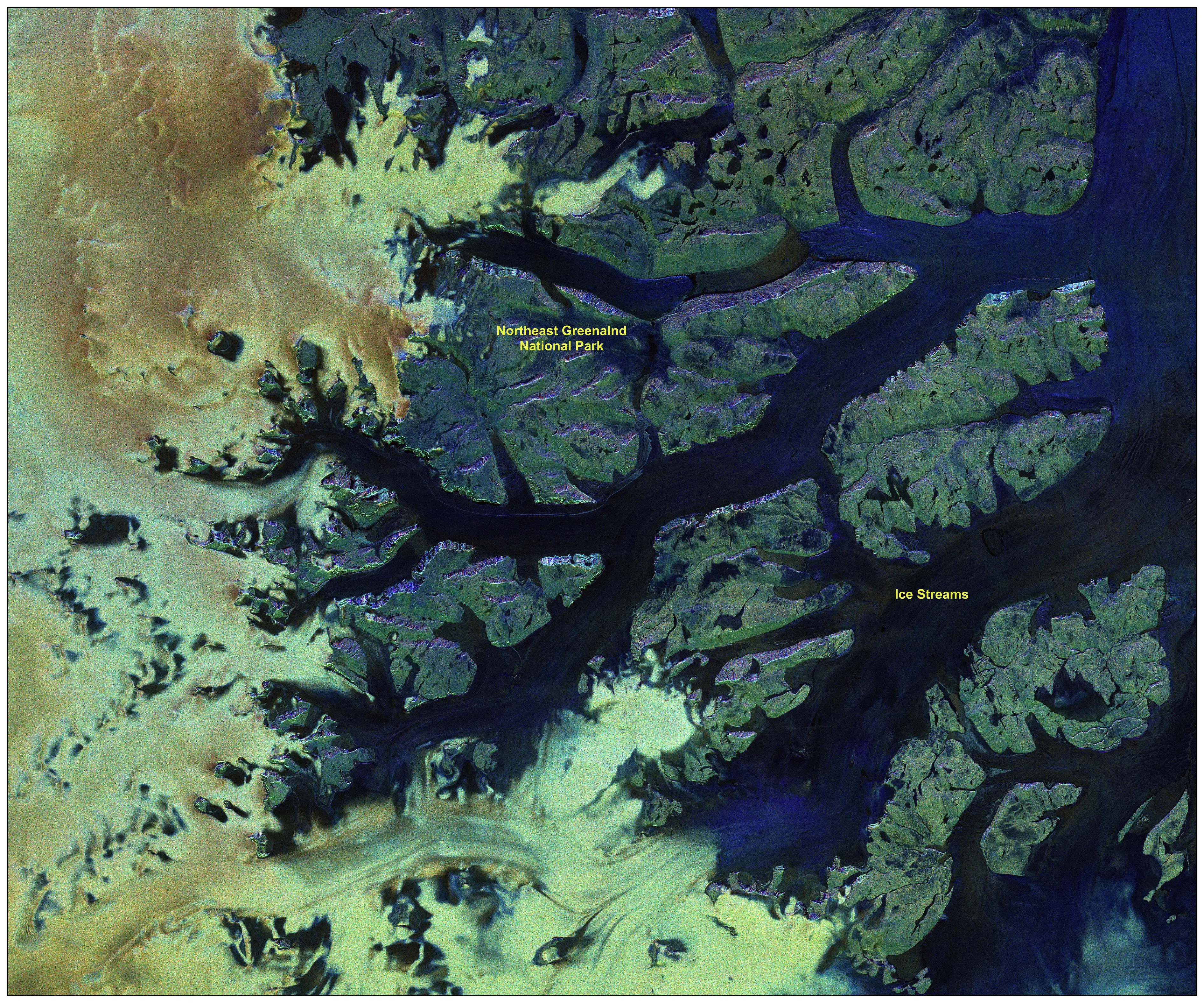
AOI: Greenland
Polarimetric
Decomposition Legend
Red – Even
Bounce
Green –
Volume
Blue – Odd
Bounce
This Hybrid Polarimetric M-Chi decomposition image derived from NISAR
S-SAR hybrid Polarimetric data highlights the dominant scattering
mechanisms across Northeast Greenland National Park acquired on 18 July
2026. Surface scattering (blue) is prominent over smooth water surfaces
and ice streams, double-bounce scattering (red) is associated with rough
exposed terrain and ice–rock interfaces, while volume scattering (green)
represents tundra vegetation and heterogeneous land surfaces. The
decomposition enhances the characterization of cryospheric and
hydrological features, supporting glacier monitoring, ice dynamics, and
environmental change assessment.
NISAR_S2_PR_GCOV_025_024_A_173_3700_DHNA_A_20260709T215709_20260709T215746_P00500_M_F_I_001

AOI: Indonesia
FCC Legend
Red – HH
Green –
HV
Blue – HH /
HV
This false-color composite (FCC), generated from the NISAR S-band GCOV
product acquired on 9 July 2026 in HH+HV, highlights dense vegetation
(green), sparsely vegetated and exposed volcanic terrain (purple), and
water bodies (dark) across Mount Rinjani National Park, Indonesia. The
composite enhances the discrimination of forest cover, volcanic
landforms, and the crater lake through variations in radar backscatter
characteristics. The image provides valuable information for ecosystem
monitoring, volcanic terrain mapping, and environmental change
assessment.